 Old Cumbria Gazetteer
 |
 |
|
| Low Wood Hotel, Lakes | ||
| Low Wood Hotel | ||
| Lowwood Hotel | ||
| locality:- | Low Wood | |
| civil parish:- | Lakes (formerly Westmorland) | |
| county:- | Cumbria | |
| locality type:- | inn | |
| locality type:- | boating | |
| coordinates:- | NY38570206 | |
| 1Km square:- | NY3802 | |
| 10Km square:- | NY30 | |
|
|
||
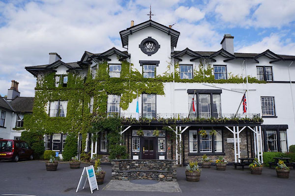 CAO20.jpg (taken 2.5.2014) 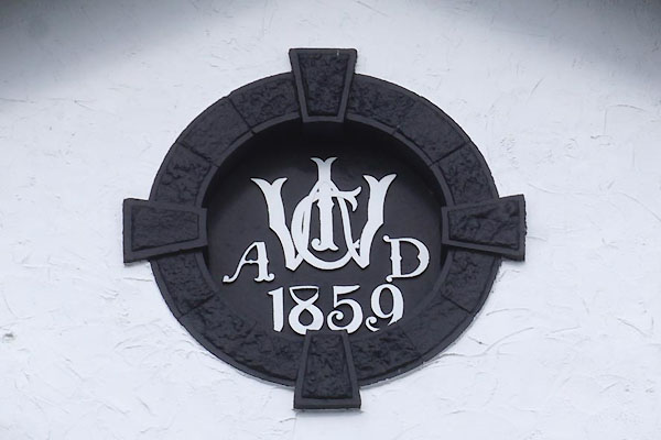 CAO21.jpg Date stone for this part of the hotel, monogram:- "[CIW] / A D / 1859" (taken 2.5.2014) |
||
|
|
||
| evidence:- | old map:- OS County Series (Wmd 26 15) placename:- Low Wood Hotel placename:- Wood Hotel, Low |
|
| source data:- | Maps, County Series maps of Great Britain, scales 6 and 25
inches to 1 mile, published by the Ordnance Survey, Southampton,
Hampshire, from about 1863 to 1948. |
|
|
|
||
| evidence:- | descriptive text:- West 1778 (11th edn 1821) placename:- Low Wood Inn item:- cannon; echoes |
|
| source data:- | Guide book, A Guide to the Lakes, by Thomas West, published by
William Pennington, Kendal, Cumbria once Westmorland, and in
London, 1778 to 1821. goto source goto sourcePage 73, footnote:- "The Low-Wood Inn, about two miles short of Ambleside, will attract the Tourist's notice. No other Inn in his route has so fine a view of a Lake, and the natural beauties of which he is in quest. A small cannon is kept here to gratify the curious with those remarkable reverberations of sound, which follow the report of a gun, &c. in these singular vales, and of which, a general description is given in the subsequent lines:-" "... The cannon's roar / Bursts from the bosom of the hollow shore. / The dire explosion the whole concave fills, / And shakes the firm foundation of the hills, / Now pausing deep, now bellowing from afar, / Now rages near the elemental war; / Affrighted echo opens all her cells, / With gather'd strength the posting clamour swells, / Check'd or impell'd, and varying in its course, / It slumbers, now awakes with double force, / Searching the strait, the crooked hill and dale, / Sinks in the breeze, or rises in the gale; / Chorus of earth and sky! the mountains sing, / And heaven's own thunders thro' the valleys ring." "Killarney. X." |
|
|
|
||
| evidence:- | old map:- Crosthwaite 1783-94 (Win/Ble) placename:- Low Wood Inn |
|
| source data:- | Map, uncoloured engraving, An Accurate Map of the Grand Lake of
Windermere, scale about 2 inches to 1 mile, by Peter
Crosthwaite, Keswick, Cumberland, 1783, version published 1819.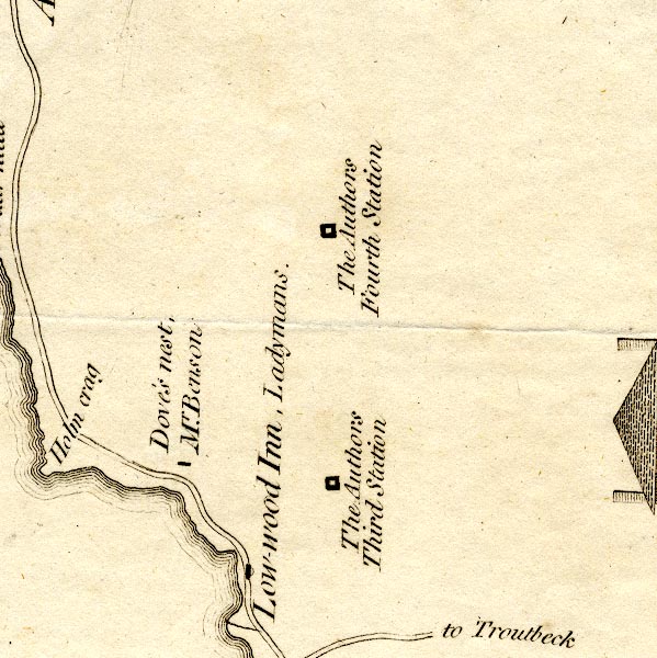 CT9NY30W.jpg "Low-wood inn, Ladymans" block, building/s 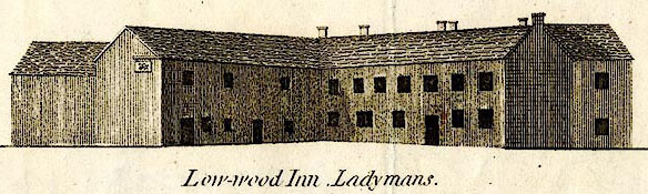 CT09Vgn4.jpg "Low-wood Inn, Ladymans." item:- Armitt Library : 2008.14.102 Image © see bottom of page |
|
|
|
||
| evidence:- | old map:- West 1784 map placename:- Low Wood |
|
| source data:- | Map, hand coloured engraving, A Map of the Lakes in Cumberland,
Westmorland and Lancashire, scale about 3.5 miles to 1 inch,
engraved by Paas, 53 Holborn, London, about 1784. Ws02NY30.jpg item:- Armitt Library : A1221.1 Image © see bottom of page |
|
|
|
||
| evidence:- | old text:- Clarke 1787 item:- boat; rowing boat |
|
| source data:- | Guide book, A Survey of the Lakes of Cumberland, Westmorland,
and Lancashire, written and published by James Clarke, Penrith,
Cumberland, and in London etc, 1787; published 1787-93. goto source Page 133:- "..." "WE will now leave Ambleside, the situation of which (see plate X.) and taking the Lake Winandermere on the right, travel along a pleasant road to Low wood, a convenient inn, where boats are kept for the use of the curious traveller; ..." |
|
|
|
||
| evidence:- | old map:- Clarke 1787 map (Windermere N) placename:- Low Wood |
|
| source data:- | Map, A Map of the Northern Part of the Lake Winandermere and its
Environs, scale about 6.5 ins to 1 mile, by James Clarke,
engraved by Samuel John Neele, 352 Strand, published by James
Clarke, Penrith, Cumberland and in London etc, 1787. CLANY30V.jpg "Low Wood / Jas. Wilson Esqr." item:- private collection : 10.10 Image © see bottom of page |
|
|
|
||
| evidence:- | road book:- Cary 1798 (2nd edn 1802) placename:- Lowood Inn |
|
| source data:- | Road book, itineraries, Cary's New Itinerary, by John Cary, 181
Strand, London, 2nd edn 1802. goto source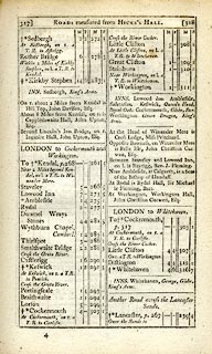 click to enlarge click to enlargeC38317.jpg page 317-318 "Lowood Inn" "INNS. Lowood Inn. ..." item:- JandMN : 228.1 Image © see bottom of page |
|
|
|
||
| evidence:- | old text:- Gents Mag item:- cannon; echoes |
|
| source data:- | Magazine, The Gentleman's Magazine or Monthly Intelligencer or
Historical Chronicle, published by Edward Cave under the
pseudonym Sylvanus Urban, and by other publishers, London,
monthly from 1731 to 1922. goto source Gentleman's Magazine 1805 p.1010 "... On our return to Low-wood, we were saluted with a reiterated chorus. The report of a small cannon fired from the shores of the Lake had awakened drowsy Echo from her cell." |
|
|
|
||
| evidence:- | old text:- Gents Mag |
|
| source data:- | Magazine, The Gentleman's Magazine or Monthly Intelligencer or
Historical Chronicle, published by Edward Cave under the
pseudonym Sylvanus Urban, and by other publishers, London,
monthly from 1731 to 1922. goto source Gentleman's Magazine 1805 p.806 "... we took shelter in the delicious repose of Low Wood, a spot which I soon ventured to predict, would, at no very distant period, become the favourite resort of every Northern traveller who has any correct taste for the wild or beautiful in Nature!" |
|
|
|
||
| evidence:- | old map:- Laurie and Whittle 1806 placename:- Lowood Inn |
|
| source data:- | Road map, Completion of the Roads to the Lakes, scale about 10
miles to 1 inch, by Nathaniel Coltman? 1806, published by Robert
H Laurie, 53 Fleet Street, London, 1834. click to enlarge click to enlargeLw18.jpg "Lowood Inn 277" inn; distance from London item:- private collection : 18.18 Image © see bottom of page |
|
|
|
||
| evidence:- | old text:- Wordsworth 1810 placename:- Lowwood Inn |
|
| source data:- | Guide book, A Description of the Scenery of the Lakes, later A
Guide through the District of The Lakes, by William Wordsworth,
1810-35. goto source page vii "... Low-wood Inn, a mile from the head of Windermere, is a most pleasant halting-place; no inn in the whole district is so agreeably situated for water views and excursions; ..." |
|
|
|
||
| evidence:- | old map:- Otley 1818 placename:- Low Wood |
|
| source data:- | Map, uncoloured engraving, The District of the Lakes,
Cumberland, Westmorland, and Lancashire, scale about 4 miles to
1 inch, by Jonathan Otley, 1818, engraved by J and G Menzies,
Edinburgh, Scotland, published by Jonathan Otley, Keswick,
Cumberland, et al, 1833. OT02NY30.jpg item:- JandMN : 48.1 Image © see bottom of page |
|
|
|
||
| evidence:- | old print:- Fielding and Walton 1821 (plate 12) placename:- Low Wood Inn |
|
| source data:- | Print, coloured aquatint, Low Wood Inn, Westmorland, drawn by Theodore H A Fielding,
published by R Ackermann, 101 Strand, London, 1821.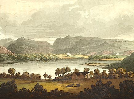 click to enlarge click to enlargeFW0112.jpg Tipped in opposite p.70 in A Picturesque Tour of the English Lakes. item:- Dove Cottage : 1993.R566.12 Image © see bottom of page |
|
|
|
||
| evidence:- | descriptive text:- Otley 1823 (5th edn 1834) placename:- Low Wood Inn item:- viewpoint; geology |
|
| source data:- | Guide book, A Concise Description of the English Lakes, the
mountains in their vicinity, and the roads by which they may be
visited, with remarks on the mineralogy and geology of the
district, by Jonathan Otley, published by the author, Keswick,
Cumberland now Cumbria, by J Richardson, London, and by Arthur
Foster, Kirkby Lonsdale, Cumbria, 1823; published 1823-49,
latterly as the Descriptive Guide to the English Lakes. goto source Page 4:- "... Low Wood Inn stands sweetly at the edge of the water; ..." goto sourcePage 101:- "LOW WOOD INN" "Is a convenient place to take a boat upon the lake, and the high ground above it commands excellent views. ..." goto sourcePage 102:- "..." "Here, while the admirer of landscape takes his views of the lake and mountain scenery from the rising ground, and the angler amuses himself upon the water; the geologist may be employed in examining the position of the transition limestone and the slate, where they have been worked, in two adjoining quarries near the road, about a quarter of a mile north of the inn." goto sourcePage 158:- "The THIRD division - forming only inferior elevations - commences with a bed of dark-blue or blackish transition limestone, containing here and there a few shells and madrepores, and alternating with a slaty rock of the same colour; the different layers of each being in some places several feet, in others only a few inches in thickness. This limestone crosses the river Duddon near Broughton; passing Broughton Mills it runs in a north-east direction through Torver, by the foot of the Old Man mountain, and appears near Low Yewdale and Yew Tree. Here it makes a considerable slip to the eastward, after which it ranges past the Tarns upon the hills above Borwick Ground; and stretching through Skelwith, it crosses the head of Windermere near Low Wood Inn. Then passing above Dovenest and Skelgill, it traverses the vales of Troutbeck, Kentmere, and Long Sleddale;" |
|
|
|
||
| evidence:- | old print:- Westall 1830s placename:- Low Wood Inn |
|
| source data:- | Print, aquatint panorama, Lake Windermere, from Low Wood Inn, Westmorland, drawn and
engraved by William Westall, published by Ackermann and Co, 96 Strand, London, 1830s.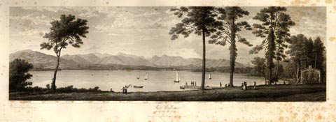 click to enlarge click to enlargeWTL307.jpg "Wetherlam. Borwick. Highwray. Hard knot. Wrynose. Bowfell 2611ft. Scawfell 3100ft. Langdale Pikes 2400ft. Brathay Hall. Gilbertscar. Clappersgate. Loughrig fell. Nabscar. Ambleside & Bowness Road. / Drawn & Engraved by W. Westall A.R.A. / Lake Windermere, / from Low Wood Inn. / Published by Ackermann & Co, 96 Strand." item:- Armitt Library : A6658.7 Image © see bottom of page |
|
|
|
||
| evidence:- | descriptive text:- Ford 1839 (3rd edn 1843) placename:- Low Wood Inn |
|
| source data:- | Guide book, A Description of Scenery in the Lake District, by
Rev William Ford, published by Charles Thurnam, Carlisle, by W
Edwards, 12 Ave Maria Lane, Charles Tilt, Fleet Street, William
Smith, 113 Fleet Street, London, by Currie and Bowman,
Newcastle, by Bancks and Co, Manchester, by Oliver and Boyd,
Edinburgh, and by Sinclair, Dumfries, 1839. goto source Page 31:- "..." "LOW WOOD INN" "Is delightfully situated on a small bay, over which are beheld Brathay Park and the Pikes of Great Langdale, Loughrigg Fell, and Fairfield; while southward, the lake steals quietly away between sloping shores adorned with woodlands and farm-steads, till the view is stopped by Curwen's Island. By those who love retirement, this inn will be chosen as a place of temporary abode, more especially since the excursions generally made from Ambleside can be equally as well accomplished from hence. Beautiful views towards each extremity of the Mere may be enjoyed from the fields above the inn and the lane leading to Troutbeck, ..." goto sourcePage 161:- "Low Wood Inn, distant from Bowness four and a half miles, is delightfully placed on the margin of a small bay, from which the head of Windermere unfolds itself with exceeding grandeur, the woods and lawns of Brathay Park bounding its receding waters, and backed by the fantastic outline of the Langdale Pikes, and their neighbouring mountain masses. The accommodation at this inn is excellent, and it is a good station for a few days' stay." |
|
|
|
||
| evidence:- | old map:- Ford 1839 map placename:- Low Wood Inn |
|
| source data:- | Map, uncoloured engraving, Map of the Lake District of
Cumberland, Westmoreland and Lancashire, scale about 3.5 miles
to 1 inch, published by Charles Thurnam, Carlisle, and by R
Groombridge, 5 Paternoster Row, London, 3rd edn 1843. FD02NY30.jpg "Low Wood Inn" item:- JandMN : 100.1 Image © see bottom of page |
|
|
|
||
| evidence:- | old print:- Garnett 1850s-60s F |
|
| source data:- | Set of prints, 6 lithographs, Views of the English Lakes, from drawings by T L Aspland,
G W Pettit, and A Pettit, engraved by William Banks, Edinburgh, published by John
Garnett, Post Office, Windermere, Westmorland, 1850s-60s?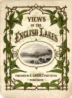 click to enlarge click to enlargeGA13T.jpg printed, cover "VIEWS / OF THE / ENGLISH LAKES / [illustration of Lowwood Hotel on Windermere] / PUBLISHED BY J. GARNET POST OFFICE / WINDERMERE / ..." item:- Armitt Library : ALMA335 Image © see bottom of page |
|
|
|
||
| evidence:- | old map:- Garnett 1850s-60s H placename:- Low Wood Inn |
|
| source data:- | Map of the English Lakes, in Cumberland, Westmorland and
Lancashire, scale about 3.5 miles to 1 inch, published by John
Garnett, Windermere, Westmorland, 1850s-60s.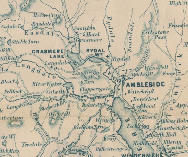 GAR2NY30.jpg "Low Wood Inn" block, building item:- JandMN : 82.1 Image © see bottom of page |
|
|
|
||
| evidence:- | old map:- Prior 1874 map 1 placename:- Low Wood Hotel |
|
| source data:- | Map, uncoloured engraving or lithograph? Winander Mere, scale
about 2.5 miles to 1 inch, published by John Garnett,
Windermere, Westmorland, 1874. click to enlarge click to enlargePI03M1.jpg "Low Wood Hotel / LOW WOOD HOTEL" block; inn; and a vignette view item:- private collection : 133.1 Image © see bottom of page |
|
|
|
||
| evidence:- | old photograph:- Bell 1880s-1940s item:- boat; rowing boat |
|
| source data:- | Photograph, sepia, Low Wood Hotel, Low Wood, Westmorland, by Herbert Bell, photographer,
Ambleside, Westmorland, 1890s.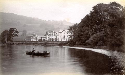 click to enlarge click to enlargeHB0822.jpg internegative at lower left:- "H. Bell" item:- Armitt Library : ALPS485 Image © see bottom of page |
|
|
|
||
| evidence:- | old photograph:- Bell 1880s-1940s item:- boat; rowing boat |
|
| source data:- | Photograph, black and white, Low Wood Hotel by lake Windermere, by Herbert Bell, Ambleside,
Westmorland, 1890s?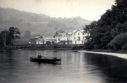 click to enlarge click to enlargeHB0226.jpg A young boy rowing a skiff in the foreground. stamped at rev:- "HERBERT BELL / Photographer / AMBLESIDE" item:- Armitt Library : 1958.5144 Image © see bottom of page |
|
|
|
||
| evidence:- | descriptive text, old map:- Burrow 1920s placename:- Low Wood |
|
| source data:- | Road book, On the Road, Dunlop Pictorial Road Plans, volume V,
strip maps with parts in Westmorland, Cumberland etc, irregular
scale about 1.5 miles to 1 inch, by E J Burrow and Co,
Cheltenham, Gloucestershire, 1920s. "... closer at hand, right upon our course, is the beauty spot of Low Wood, on the shore of the lake [Windermere], where steamers embark passengers for trips down the long narrow lake. ..." 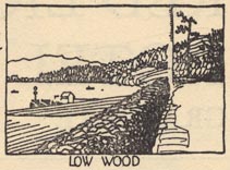 EJB3Vg35.jpg item:- private collection : 17 Image © see bottom of page |
|
|
|
||
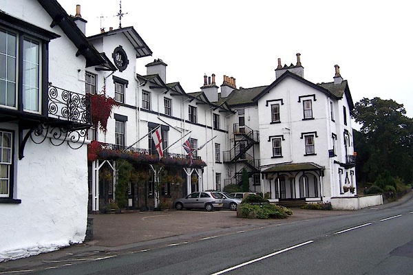
| evidence:- | database:- Listed Buildings 2010 placename:- Low Wood Hotel |
|
| source data:- | courtesy of English Heritage "LOW WOOD HOTEL / / WINDERMERE ROAD / LAKES / SOUTH LAKELAND / CUMBRIA / II / 451908 / NY3857202064" |
|
| source data:- | courtesy of English Heritage "C18 coaching inn used by the Lake poets and writers, extended 1859. Exclude C20 portion to north. Very long range of building along the lake shore, mainly 3 storeys. Main block in centre has 9 windows on top floor, each with a projecting gable above, and the one over the entrance is in a higher tower-like portion with the dated roundel (1859) above the roofline. Ground and 1st floors have some double or treble sashes, and an iron balcony extends over the centre 4 bays, on coupled piers. A 3-storeyed wing projects towards the lake on the south and has a lean-to verandah of clustered columns and Gothic imposts, over a ground floor of 2 large open pointed arches with slender colonnettes. Serve Tudor arched windows, Gothic labels, iron balconies, and an ogee-headed niche." |
|
|
|
||
| evidence:- | outline view:- Red Guide 1892 placename:- Low Wood Inn |
|
| source data:- | Print, engraving, pair of outline views, Mountains as seen from Low Wood Inn, and
Mountains as seen from the Elevation on the Road opposite the Inn at Strands in Wasdale,
published by Ward, Lock and Co, Warwick House, Salisbury Square, London, etc, 1892.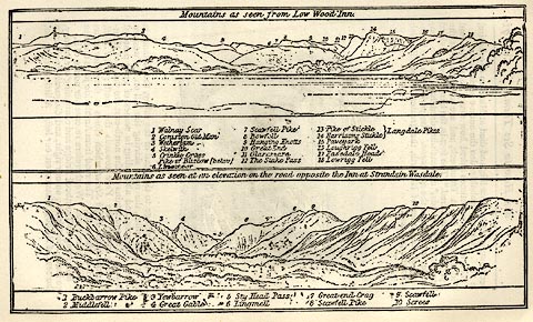 click to enlarge click to enlargeRG0101.jpg "1 Walnay Scar 2 Coniston Old Man 3 Wetherlam 4 Skelwith 5 Crinkle Crags / Pike of Bliscow (below) 6 [ ]oor 7 Scawfell Pike 8 Bowfell 9 Hanging Knotts 10 Great End 11 Glaramara 12 The Stake Pass 13 Pike of Stickle / Langdale Pikes 14 Harrisons Stickle 15 Paveyark 16 Loughrigg Fell 17 Easedale Head 18 Lowrigg Fell" On p.72 in the Red Guide guide book, Guide to the English Lakes. item:- JandMN : 102.2 Image © see bottom of page |
|
|
|
||
| evidence:- | old print:- Martineau 1855 placename:- Lowood Hotel |
|
| source data:- | Print, engraving, Windermere from Lowood Hotel, drawn and engraved by W Banks, Edinburgh,
published by John Garnett, Windermere, Westmorland, and by Whittaker and Co, London,
1855.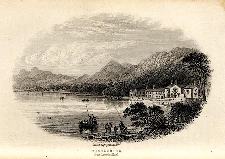 click to enlarge click to enlargeMNU104.jpg Opposite p.19 in A Complete Guide to the English Lakes, by Harriet Martineau. printed at bottom:- "Drawn &Eng'd by W Banks Edinr. / WINDERMERE / from Lowood Hotel." item:- Armitt Library : A1159.4 Image © see bottom of page |
|
|
|
||
| evidence:- | old print:- placename:- Low Wood Hotel item:- steamer; Dragon Fly item:- water |
|
| source data:- | Print, uncoloured engraving, Launch of the Dragon Fly Steamer on Lake Windermere,
Westmorland, published in the Illustrated London News, 30 November 1850.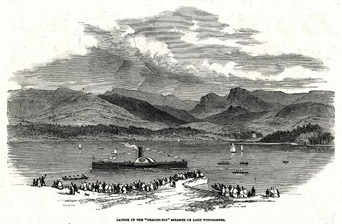 click to enlarge click to enlargePR0565.jpg The text includes:- LAUNCH OF THE "DRAGON-FLY" STEAMER ON LAKE WINDERMERE ... This new steamer was built by Messrs. M'Conochie and Claude, engineers, Liverpool, and was christened the Dragon-Fly by Mrs Rigg, the lady of the Secretary of the Company. After the launch, a large party sat down to an excellent dinner, at Mr. Logan's, Low Wood Hotel. item:- Dove Cottage : 2008.107.513 Image © see bottom of page |
|
|
|
||
| evidence:- | old print:- placename:- Low Wood Hotel item:- boat item:- innkeeper |
|
| source data:- | Print, uncoloured engraving, At Low Wood Hotel, Windermere, Westmorland, by ?B Foster,
engraved by E Evans, 1850s-60s?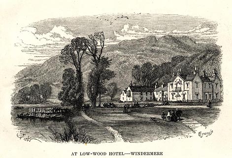 click to enlarge click to enlargePR0496.jpg printed at bottom left, right, centre:- "[B] Foster / E. EVANS SC. / AT LOW WOOD HOTEL - WINDERMERE" item:- Dove Cottage : 2008.107.445 Image © see bottom of page |
|
|
|
||
| evidence:- | old advertisement:- Atkinson 1847 (5th edn 1850) placename:- Low Wood Hotel |
|
| source data:- | Advertisement for Robert Logan at the Low Wood Hotel, Windermere, Westmorland, 1850.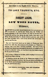 click to enlarge click to enlargeAK2A07.jpg At the end of a Handbook to the English Lakes, 5th edn. item:- Armitt Library : A1144.18 Image © see bottom of page |
|
|
|
||
 BJX49.jpg Part built 1859. (taken 7.10.2005)  BJX48.jpg An older bit. (taken 7.10.2005) 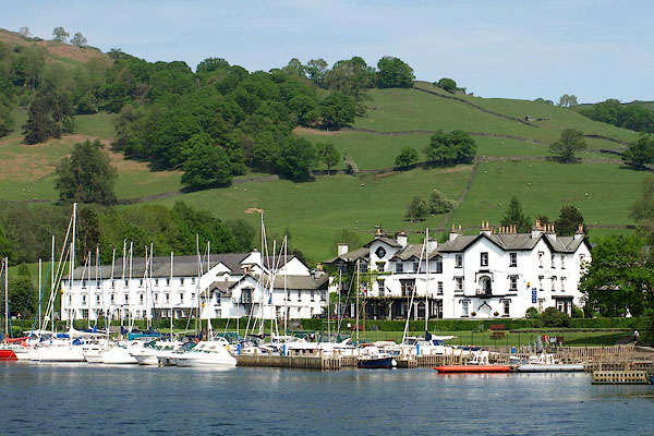 BPE82.jpg (taken 12.5.2008) 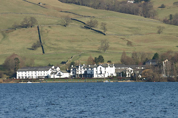 BOR30.jpg (taken 15.2.2008) |
||
|
|
||
Lakes Guides menu.