 Old Cumbria Gazetteer
 |
 |
|
||||||||||||||||||||||||||||||||||||||||||||||||||||
| Helvellyn, St John's Castlerigg etc | ||||||||||||||||||||||||||||||||||||||||||||||||||||||
| Helvellyn | ||||||||||||||||||||||||||||||||||||||||||||||||||||||
| civil parish:- | St John's Castlerigg and Wythburn (formerly Cumberland) | |||||||||||||||||||||||||||||||||||||||||||||||||||||
| civil parish:- | Patterdale (formerly Westmorland) | |||||||||||||||||||||||||||||||||||||||||||||||||||||
| county:- | Cumbria | |||||||||||||||||||||||||||||||||||||||||||||||||||||
| locality type:- | hill | |||||||||||||||||||||||||||||||||||||||||||||||||||||
| coordinates:- | NY34241511 | |||||||||||||||||||||||||||||||||||||||||||||||||||||
| 1Km square:- | NY3415 | |||||||||||||||||||||||||||||||||||||||||||||||||||||
| 10Km square:- | NY31 | |||||||||||||||||||||||||||||||||||||||||||||||||||||
| altitude:- | 3117 feet | |||||||||||||||||||||||||||||||||||||||||||||||||||||
| altitude:- | 950m | |||||||||||||||||||||||||||||||||||||||||||||||||||||
|
|
||||||||||||||||||||||||||||||||||||||||||||||||||||||
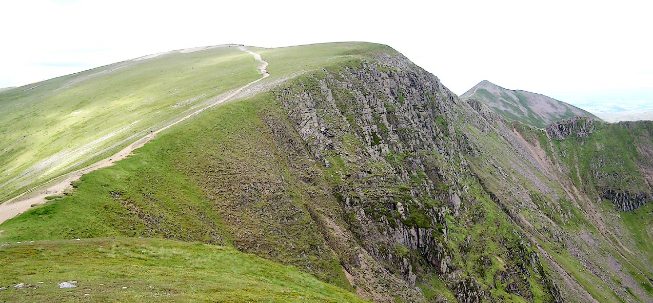 Click to enlarge BRB55.jpg (taken 9.7.2009) 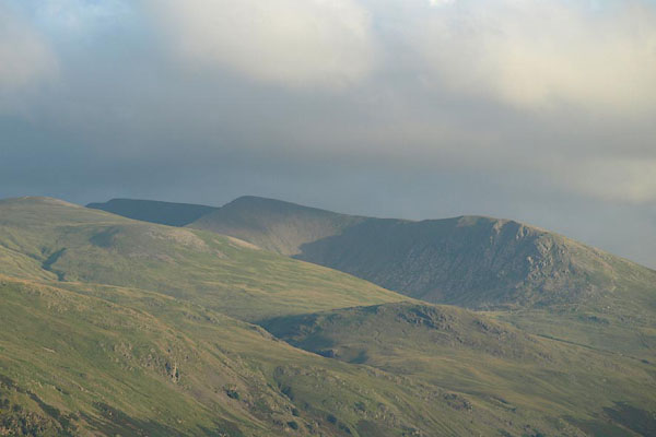 BPQ16.jpg From the face of Saddleback. (taken 24.8.2008) |
||||||||||||||||||||||||||||||||||||||||||||||||||||||
|
|
||||||||||||||||||||||||||||||||||||||||||||||||||||||
| evidence:- | old map:- OS County Series (Wmd 12 13) placename:- Helvellyn |
|||||||||||||||||||||||||||||||||||||||||||||||||||||
| source data:- | Maps, County Series maps of Great Britain, scales 6 and 25
inches to 1 mile, published by the Ordnance Survey, Southampton,
Hampshire, from about 1863 to 1948. OS County Series (Cmd 71 9) |
|||||||||||||||||||||||||||||||||||||||||||||||||||||
|
|
||||||||||||||||||||||||||||||||||||||||||||||||||||||
| evidence:- | old map:- Saxton 1579 placename:- Helvillon Hill |
|||||||||||||||||||||||||||||||||||||||||||||||||||||
| source data:- | Map, hand coloured engraving, Westmorlandiae et Cumberlandiae Comitatus ie Westmorland
and Cumberland, scale about 5 miles to 1 inch, by Christopher Saxton, London, engraved
by Augustinus Ryther, 1576, published 1579-1645.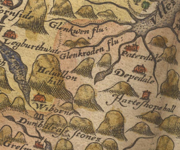 Sax9NY31.jpg "Helvillon hill" Large hillock. item:- private collection : 2 Image © see bottom of page |
|||||||||||||||||||||||||||||||||||||||||||||||||||||
|
|
||||||||||||||||||||||||||||||||||||||||||||||||||||||
| evidence:- | old map:- Mercator 1595 (edn?) placename:- Helvillon Hill |
|||||||||||||||||||||||||||||||||||||||||||||||||||||
| source data:- | Map, hand coloured engraving, Northumbria, Cumberlandia, et
Dunelmensis Episcopatus, ie Northumberland, Cumberland and
Durham etc, scale about 6.5 miles to 1 inch, by Gerard Mercator,
Duisberg, Germany, about 1595.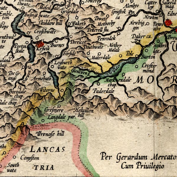 MER8CumF.jpg "Helvillon hill" hillock, shaded on east; hill or mountain, on county boundary item:- JandMN : 169 Image © see bottom of page |
|||||||||||||||||||||||||||||||||||||||||||||||||||||
|
|
||||||||||||||||||||||||||||||||||||||||||||||||||||||
| evidence:- | old map:- Speed 1611 (Wmd) placename:- Helvillon Hill |
|||||||||||||||||||||||||||||||||||||||||||||||||||||
| source data:- | Map, hand coloured engraving, The Countie Westmorland and
Kendale the Cheif Towne, scale about 2.5 miles to 1 inch, by
John Speed, 1610, published by George Humble, Popes Head Alley,
London, 1611-12.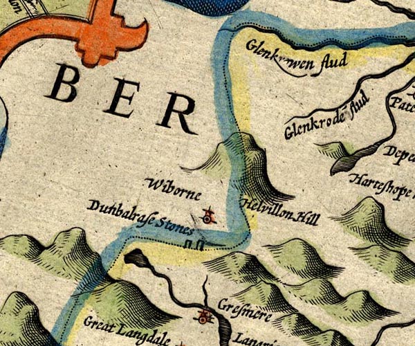 SP14NY31.jpg "Helvillon Hill" large hillock item:- Armitt Library : 2008.14.5 Image © see bottom of page |
|||||||||||||||||||||||||||||||||||||||||||||||||||||
|
|
||||||||||||||||||||||||||||||||||||||||||||||||||||||
| evidence:- | poem:- Drayton 1612/1622 text placename:- Helvillon |
|||||||||||||||||||||||||||||||||||||||||||||||||||||
| source data:- | Poem, Poly Olbion, by Michael Drayton, published by published by
John Marriott, John Grismand and Thomas Dewe, and others?
London, part 1 1612, part 2 1622. goto source goto sourcepage 164:- "... Helvillon from his height, ..." |
|||||||||||||||||||||||||||||||||||||||||||||||||||||
|
|
||||||||||||||||||||||||||||||||||||||||||||||||||||||
| evidence:- | old map:- Drayton 1612/1622 placename:- Hellvillon Hill |
|||||||||||||||||||||||||||||||||||||||||||||||||||||
| source data:- | Map, hand coloured engraving, Cumberlande and Westmorlande, by
Michael Drayton, probably engraved by William Hole, scale about
4 or 5 miles to 1 inch, published by John Mariott, John
Grismand, and Thomas Dewe, London, 1622.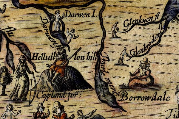 DRY514.jpg "Hellvlllon hill" Hillock with a gentleman sitting on top, with a staff; out of place!. item:- JandMN : 168 Image © see bottom of page |
|||||||||||||||||||||||||||||||||||||||||||||||||||||
|
|
||||||||||||||||||||||||||||||||||||||||||||||||||||||
| evidence:- | old map:- Jansson 1646 placename:- Helvillon Hill |
|||||||||||||||||||||||||||||||||||||||||||||||||||||
| source data:- | Map, hand coloured engraving, Cumbria and Westmoria, ie
Cumberland and Westmorland, scale about 3.5 miles to 1 inch, by
John Jansson, Amsterdam, Netherlands, 1646.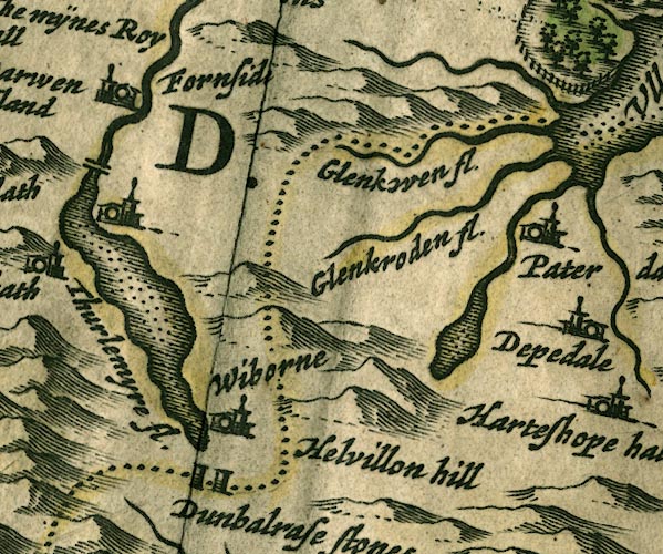 JAN3NY31.jpg "Helvillon hill" Just a hillock. item:- JandMN : 88 Image © see bottom of page |
|||||||||||||||||||||||||||||||||||||||||||||||||||||
|
|
||||||||||||||||||||||||||||||||||||||||||||||||||||||
| evidence:- | old map:- Ogilby 1675 (plate 96) |
|||||||||||||||||||||||||||||||||||||||||||||||||||||
| source data:- | Road strip map, hand coloured engraving, the Road from Kendal to
Cockermouth, and the Road from Egremond to Carlisle, scale about
1 inch to 1 mile, by John Ogilby, London, 1675. OG96m020.jpg In miles 20 to 24, Cumberland. Range of mountain on the right of the road for 4 miles. item:- JandMN : 22 Image © see bottom of page |
|||||||||||||||||||||||||||||||||||||||||||||||||||||
|
|
||||||||||||||||||||||||||||||||||||||||||||||||||||||
| evidence:- | old map:- Morden 1695 (Wmd) placename:- Helvillin Hill |
|||||||||||||||||||||||||||||||||||||||||||||||||||||
| source data:- | Map, hand coloured engraving, Westmorland, scale about 2.5 miles to 1 inch, by Robert
Morden, published by Abel Swale, the Unicorn, St Paul's Churchyard, Awnsham, and John
Churchill, the Black Swan, Paternoster Row, London, 1695.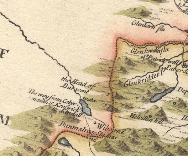 MD10NY31.jpg "Helvillin hill" Marked with a circle on the side of the hillock. item:- JandMN : 24 Image © see bottom of page |
|||||||||||||||||||||||||||||||||||||||||||||||||||||
|
|
||||||||||||||||||||||||||||||||||||||||||||||||||||||
| evidence:- | descriptive text:- Simpson 1746 placename:- Lauvellin |
|||||||||||||||||||||||||||||||||||||||||||||||||||||
| source data:- | Atlas, three volumes of maps and descriptive text published as
'The Agreeable Historian, or the Compleat English Traveller
...', by Samuel Simpson, 1746. goto source "..." "Some of the Mountains in Cumberland are very remarkable for their Height, viz. ... The third is Lauvellin, the fourth Castinand, of which, and the former, they have a proverbial Speech among them:" "Skiddaw, Lauvellin, and Castinand," "Are th' highest Hills in all England." |
|||||||||||||||||||||||||||||||||||||||||||||||||||||
|
|
||||||||||||||||||||||||||||||||||||||||||||||||||||||
| evidence:- | old map:- Bowen and Kitchin 1760 placename:- Helvillon Hill |
|||||||||||||||||||||||||||||||||||||||||||||||||||||
| source data:- | Map, hand coloured engraving, A New Map of the Counties of
Cumberland and Westmoreland Divided into their Respective Wards,
scale about 4 miles to 1 inch, by Emanuel Bowen and Thomas
Kitchin et al, published by T Bowles, Robert Sayer, and John
Bowles, London, 1760.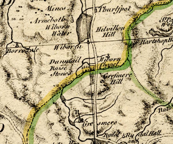 BO18NY20.jpg "Helvillon Hill" hill hachuring, on county boundary Westmorland Cumberland item:- Armitt Library : 2008.14.10 Image © see bottom of page |
|||||||||||||||||||||||||||||||||||||||||||||||||||||
|
|
||||||||||||||||||||||||||||||||||||||||||||||||||||||
| evidence:- | old map:- Jefferys 1770 (Wmd) placename:- Helvellin |
|||||||||||||||||||||||||||||||||||||||||||||||||||||
| source data:- | Map, 4 sheets, The County of Westmoreland, scale 1 inch to 1
mile, surveyed 1768, and engraved and published by Thomas
Jefferys, London, 1770. J5NY31NW.jpg "HELVELLIN" hill hachuring; hill or mountain; across county boundary item:- National Library of Scotland : EME.s.47 Image © National Library of Scotland |
|||||||||||||||||||||||||||||||||||||||||||||||||||||
|
|
||||||||||||||||||||||||||||||||||||||||||||||||||||||
| evidence:- | old map:- Donald 1774 (Cmd) placename:- Helvellin |
|||||||||||||||||||||||||||||||||||||||||||||||||||||
| source data:- | Map, hand coloured engraving, 3x2 sheets, The County of Cumberland, scale about 1
inch to 1 mile, by Thomas Donald, engraved and published by Joseph Hodskinson, 29
Arundel Street, Strand, London, 1774. D4NY31NW.jpg "HELVELLIN" 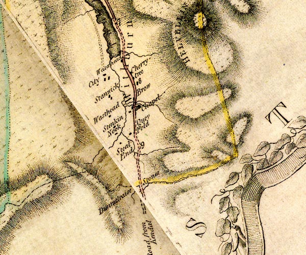 D4NY31SW.jpg hill hachuring; hill or mountain, on county boundary item:- Carlisle Library : Map 2 Images © Carlisle Library |
|||||||||||||||||||||||||||||||||||||||||||||||||||||
|
|
||||||||||||||||||||||||||||||||||||||||||||||||||||||
| evidence:- | descriptive text:- West 1778 (11th edn 1821) item:- snow; weather |
|||||||||||||||||||||||||||||||||||||||||||||||||||||
| source data:- | Guide book, A Guide to the Lakes, by Thomas West, published by
William Pennington, Kendal, Cumbria once Westmorland, and in
London, 1778 to 1821. goto source Page 83:- "..." "... The range of mountains, on the right [at Leathes Water], are tre-" goto sourcePage 84:- "[tre]mendously great. Helvellyn and Cachidecam are the chief; and, according to Wythburn shepherds, much higher than Skiddaw. It is, however, certain that these mountains retain snow many weeks after Skiddaw; but that may be owing to the steepness of Skiddaw's northern side, and shivery surface, that attracts more forcibly the solar rays, than the verdant front of Helvellyn, and so sooner looses its winter covering. A thousand huge rocks hang on Helvellyn's brow, which have been once in motion, and are now seemingly prepared to start anew. Many have already reached the lake, and are at rest. The road sweeps through them, along the naked margin of the lake." "..." goto sourcePage 190:- "A TABLE OF THE Height of Mountains and Lakes SEEN IN THIS TOUR, ... TAKEN FROM THE LEVEL OF THE SEA. ... by Mr. John Dalton." "Helvellyn ... 1070 [yards]" "..." "... no mountain in England touches the zone of barrenness that intervenes between this region and the limits of vegetation. Sheep pasture the summits of Snowden, Helvellyn, and Skiddaw, and barrenness only prevails where rock and precipice are invincible obstacles to vegetation." goto sourceAddendum; Mr Gray's Journal, 1769 Page 202:- "... [Ullswater] is soon again interrupted by the root of Helvellyn, a lofty and very rugged mountain, and spreading again, turns off to the south-east, ..." goto sourcePage 208:- "... [from Castlerigg] ... the summits of Cachidecam (called by Camden Casticand) and Helvellyn, said to be as high as Skiddaw, and to rise from a much higher base." goto sourcePage 210:- "..." "Oct. 8. I left Keswick, and took the Ambleside road, ... Came to the foot of Helvellyn, along which runs an excellent road, looking down from a little height on Leathes-water, ... all is rock and loose stones up to the very brow, which lies so near your way that not above half the height of Helvellyn can be seen." goto sourceMr Cumberland's Ode to the Sun, 1776 Page 224:- "SOUL of the world, refulgent sun! / Oh, take not from my ravish'd sight / Those golden beams of living light, / Nor, ere thy daily course be run, / Precipitate the night. / Lo! where ruffian clouds arise, / Usurp the abdicated skies, / And seize the aethereal throne: / Sullen sad the scene appears, / Huge Helvellyn streams with tears! / Hark! 'tis giant Skiddaw's groan, / I hear terrific Lowdore roar; / The sabbath of thy reign is o'er, / The anarchy's begun; / Father of light! return; break forth, refulgent sun!" |
|||||||||||||||||||||||||||||||||||||||||||||||||||||
|
|
||||||||||||||||||||||||||||||||||||||||||||||||||||||
| evidence:- | old map:- West 1784 map placename:- Helvellyn |
|||||||||||||||||||||||||||||||||||||||||||||||||||||
| source data:- | Map, hand coloured engraving, A Map of the Lakes in Cumberland,
Westmorland and Lancashire, scale about 3.5 miles to 1 inch,
engraved by Paas, 53 Holborn, London, about 1784. Ws02NY31.jpg "HELVELLYN" Shown by a circle of hachuring across the county boundary. item:- Armitt Library : A1221.1 Image © see bottom of page |
|||||||||||||||||||||||||||||||||||||||||||||||||||||
|
|
||||||||||||||||||||||||||||||||||||||||||||||||||||||
| evidence:- | old text:- Clarke 1787 placename:- Lauvellin placename:- Helveyllin |
|||||||||||||||||||||||||||||||||||||||||||||||||||||
| source data:- | Guide book, A Survey of the Lakes of Cumberland, Westmorland,
and Lancashire, written and published by James Clarke, Penrith,
Cumberland, and in London etc, 1787; published 1787-93. goto source Page 116:- "... the highest of our northern Alps, Helvellyn." "Cambden speaking of Helvellyn calls it Lauvellin, and says that the country people had a proverb concerning it." ""Skiddow, Lauvellin, and Casticand, Are the highest hills in all England."" ""But the bye-word (as he calls it,) that he was taught when a child, and which continues the same still, is," ""Kidstowpike, Castycam, Helveyllin and Skiddow-man, Are the highest hills ever clumb by Englishmen."" |
|||||||||||||||||||||||||||||||||||||||||||||||||||||
|
|
||||||||||||||||||||||||||||||||||||||||||||||||||||||
| evidence:- | old print:- Clarke 1787 placename:- Hellvellyn |
|||||||||||||||||||||||||||||||||||||||||||||||||||||
| source data:- | circle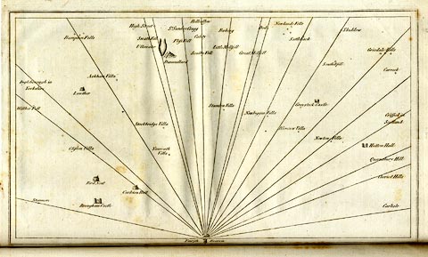 click to enlarge click to enlargeCL18.jpg "Hellvellyn" item:- Armitt Library : A6615.12 Image © see bottom of page |
|||||||||||||||||||||||||||||||||||||||||||||||||||||
|
|
||||||||||||||||||||||||||||||||||||||||||||||||||||||
| evidence:- | old map:- Clarke 1787 map (Ambleside to Keswick) placename:- Hellvellin Mount |
|||||||||||||||||||||||||||||||||||||||||||||||||||||
| source data:- | Map, A Map of the Roads Lakes etc between Keswick and Ambleside,
scale about 2.5 ins to 1 mile, by James Clarke, engraved by S J
Neele, 352 Strand, published by James Clarke, Penrith,
Cumberland and in London etc, 1787. CL9NY31I.jpg "HELLVELLIN MOUNT" Off to the side. item:- private collection : 10.9 Image © see bottom of page |
|||||||||||||||||||||||||||||||||||||||||||||||||||||
|
|
||||||||||||||||||||||||||||||||||||||||||||||||||||||
| evidence:- | old text:- Camden 1789 placename:- Lawellin item:- proverb |
|||||||||||||||||||||||||||||||||||||||||||||||||||||
| source data:- | Book, Britannia, or A Chorographical Description of the Flourishing Kingdoms of England,
Scotland, and Ireland, by William Camden, 1586, translated from the 1607 Latin edition
by Richard Gough, published London, 1789. goto source Page 170:- "..." "And that other of the height of these [Skiddaw] and two other mountains in these parts," "Skiddaw, Lawellin, and Casticand Are the highest hills in all England." |
|||||||||||||||||||||||||||||||||||||||||||||||||||||
|
|
||||||||||||||||||||||||||||||||||||||||||||||||||||||
| evidence:- | old map:- Cary 1789 (edn 1805) placename:- Helvelein |
|||||||||||||||||||||||||||||||||||||||||||||||||||||
| source data:- | Map, uncoloured engraving, Westmoreland, scale about 2.5 miles
to 1 inch, by John Cary, London, 1789; edition 1805.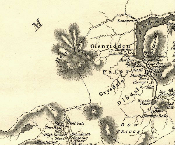 CY24NY31.jpg "Helvelein" hill hachuring item:- JandMN : 129 Image © see bottom of page |
|||||||||||||||||||||||||||||||||||||||||||||||||||||
|
|
||||||||||||||||||||||||||||||||||||||||||||||||||||||
| evidence:- | old map:- Cooke 1802 placename:- Helvellin |
|||||||||||||||||||||||||||||||||||||||||||||||||||||
| source data:- | Map, The Lakes, Westmorland and Cumberland, scale about 8.5
miles to 1 inch, engravedby Neele and Son, published by
Sherwood, Jones and Co, Paternoster Road, London, 1824. click to enlarge click to enlargeGRA1Lk.jpg "Helvellin" hillock; mountain, on county boundary item:- Hampshire Museums : FA2000.62.5 Image © see bottom of page |
|||||||||||||||||||||||||||||||||||||||||||||||||||||
|
|
||||||||||||||||||||||||||||||||||||||||||||||||||||||
| evidence:- | old text:- Gents Mag item:- altitude, Helvellyn |
|||||||||||||||||||||||||||||||||||||||||||||||||||||
| source data:- | Magazine, The Gentleman's Magazine or Monthly Intelligencer or
Historical Chronicle, published by Edward Cave under the
pseudonym Sylvanus Urban, and by other publishers, London,
monthly from 1731 to 1922. goto source Gentleman's Magazine 1805 p.1011 "... On the right of the road Helvellyn lifts its awful form, a mountain of tremendous grandeur, upon whose brow the snow hangs as upon a glacier. The cottagers, nestling at its base, pride themselves in the shelter of this impenetrable rampire, and stoutly repel the imputation of the Keswick peasantry, who assert the greater altitude of their native Skiddaw. ..." |
|||||||||||||||||||||||||||||||||||||||||||||||||||||
|
|
||||||||||||||||||||||||||||||||||||||||||||||||||||||
| evidence:- | old text:- Capper 1808 placename:- Kellwellyn |
|||||||||||||||||||||||||||||||||||||||||||||||||||||
| source data:- | Gazetteer, A Topographical Dictionary of the United Kingdom,
compiled by Benjamin Pitts Capper, published by Richard
Phillips, Bridge Street, Blackfriars, London, 1808; published
1808-29. goto source "[Thirlmere] ... commences at the foot of mount Kellwellyn, which it skirts for 4 miles, and in that distance receives numerous torrents which descend from the mountains. ..." |
|||||||||||||||||||||||||||||||||||||||||||||||||||||
|
|
||||||||||||||||||||||||||||||||||||||||||||||||||||||
| evidence:- | old map:- Cooper 1808 placename:- Helvelin |
|||||||||||||||||||||||||||||||||||||||||||||||||||||
| source data:- | Map, hand coloured engraving, Westmoreland ie Westmorland, scale
about 9 miles to 1 inch, by H Cooper, 1808, published by R
Phillips, Bridge Street, Blackfriars, London, 1808. click to enlarge click to enlargeCOP4.jpg "Helvelin" hill hachuring; mountain or hill; on county boundary item:- Dove Cottage : 2007.38.53 Image © see bottom of page |
|||||||||||||||||||||||||||||||||||||||||||||||||||||
|
|
||||||||||||||||||||||||||||||||||||||||||||||||||||||
| evidence:- | old print:- Green 1810 (plate 28) placename:- Helvellyn |
|||||||||||||||||||||||||||||||||||||||||||||||||||||
| source data:- | Print, soft ground etching, Helvellyn, from the Foot of Leathes Water, ie Thirlmere,
St John's Castlerigg and Wythburn, Cumberland, by William Green, Ambleside, Westmorland,
1809.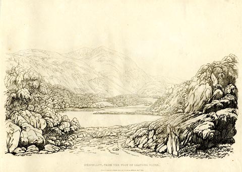 click to enlarge click to enlargeGN1228.jpg Plate 28 in Sixty Studies from Nature, 1810. printed at top right:- "28" printed at bottom:- "HELVELLYN, FROM THE FOOT OF LEATHES WATER. / Drawn &Engraved by William Green, and Published at Ambleside, Augst. 1st. 1809." watermark:- "J WHATMAN / 1813" item:- Armitt Library : A6641.28 Image © see bottom of page |
|||||||||||||||||||||||||||||||||||||||||||||||||||||
|
|
||||||||||||||||||||||||||||||||||||||||||||||||||||||
| evidence:- | old print:- Green 1814 (plate 26) |
|||||||||||||||||||||||||||||||||||||||||||||||||||||
| source data:- | Print, uncoloured soft ground etching, Foot of Leaths Water, ie Thirlmere, St John's
Castlerigg and Wythburn, Cumberland, by William Green, Ambleside, Westmorland, 1814.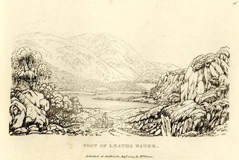 click to enlarge click to enlargeGN0926.jpg Plate 26 in Sixty Small Prints. printed at top right:- "26" printed at bottom:- "FOOT OF LEATHS WATER. / Published at Ambleside Augst. 1, 1814, by Wm. Green." item:- Armitt Library : A6656.26 Image © see bottom of page |
|||||||||||||||||||||||||||||||||||||||||||||||||||||
|
|
||||||||||||||||||||||||||||||||||||||||||||||||||||||
| evidence:- | old print:- Green 1814 (plate 26) |
|||||||||||||||||||||||||||||||||||||||||||||||||||||
| source data:- | Print, tinted soft ground etching, Foot of Leaths Water, ie Thirlmere, St John's Castlerigg
and Wythburn, Cumberland, by William Green, Ambleside, Westmorland, 1814.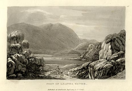 click to enlarge click to enlargeGN1026.jpg Plate 26 in Sixty Small Prints. printed at top right:- "26" printed at bottom:- "FOOT OF LEATHS WATER. / Published at Ambleside Augst. 1, 1814, by Wm. Green." item:- Armitt Library : A6653.26 Image © see bottom of page |
|||||||||||||||||||||||||||||||||||||||||||||||||||||
|
|
||||||||||||||||||||||||||||||||||||||||||||||||||||||
| evidence:- | old print with text:- Farington 1816 placename:- Helvellyn |
|||||||||||||||||||||||||||||||||||||||||||||||||||||
| source data:- | Print, uncoloured engraving and descriptive text, The Head of Ulswater, Patterdale,
and the Mountain Helvellyn, Westmorland, drawn by Joseph Farington, engraved by Samuel
Middiman, published by T Cadell and W Davies, Strand, London, 1815.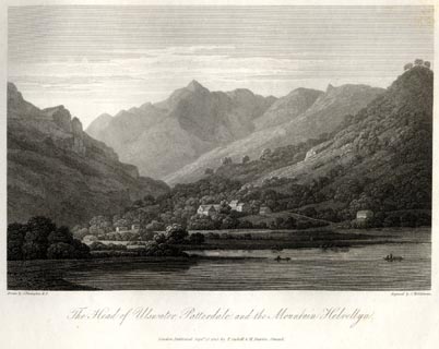 click to enlarge click to enlargeFA0404.jpg printed, bottom left, right, centre "Drawn by J. Farington R.A. / Engraved by S. Middiman. / The Head of Ulswater, Patterdale, and the Mountain Helvellyn. / London Published Septr. 15, 1815, by T. Cadell &W. Davies, Strand." Descriptive text:- "THE HEAD OF ULSWATER, PATTERDALE, AND THE MOUNTAIN HELVELLYN." "..." "In the view now under consideration, the mighty mountain Helvellyn occupies the centre of the landscape. It is situated partly in Westmoreland, and rises to the height of 3324 feet. Its front is rude and magnificently awful, stretching upwards of four miles in one vast concave ridge. Huge and innumerable fragments of rock hang pendant from its sides, and appear ready to fall and overwhelm the curious traveller who dares to ascend its rugged heights. The prospect from its summit is exceedingly extensive." "..." item:- Armitt Library : A6666.4 Image © see bottom of page |
|||||||||||||||||||||||||||||||||||||||||||||||||||||
|
|
||||||||||||||||||||||||||||||||||||||||||||||||||||||
| evidence:- | old map:- Otley 1818 placename:- Helvellyn |
|||||||||||||||||||||||||||||||||||||||||||||||||||||
| source data:- | Map, uncoloured engraving, The District of the Lakes,
Cumberland, Westmorland, and Lancashire, scale about 4 miles to
1 inch, by Jonathan Otley, 1818, engraved by J and G Menzies,
Edinburgh, Scotland, published by Jonathan Otley, Keswick,
Cumberland, et al, 1833. OT02NY31.jpg "HELVELLYN" item:- JandMN : 48.1 Image © see bottom of page |
|||||||||||||||||||||||||||||||||||||||||||||||||||||
|
|
||||||||||||||||||||||||||||||||||||||||||||||||||||||
| evidence:- | old print:- Fielding and Walton 1821 (plate 23) placename:- Helvellyn |
|||||||||||||||||||||||||||||||||||||||||||||||||||||
| source data:- | Print, coloured aquatint, Wythburn Water and Helvellyn, Cumberland, drawn by Theodore
H A Fielding, published by R Ackermann, 101 Strand, London, 1821.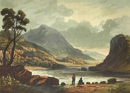 click to enlarge click to enlargeFW0123.jpg Thirlmere. Tipped in opposite p.125 in A Picturesque Tour of the English Lakes. item:- Dove Cottage : 1993.R566.23 Image © see bottom of page |
|||||||||||||||||||||||||||||||||||||||||||||||||||||
|
|
||||||||||||||||||||||||||||||||||||||||||||||||||||||
| evidence:- | outline view:- Otley 1823 (4th edn 1830) placename:- Helvellyn High Man |
|||||||||||||||||||||||||||||||||||||||||||||||||||||
| source data:- | Print, engraving, outline view, The Mountains of Ullswater as seen from Pooley Bridge,
published by Jonathan Otley, Keswick, Cumberland et al, 1830.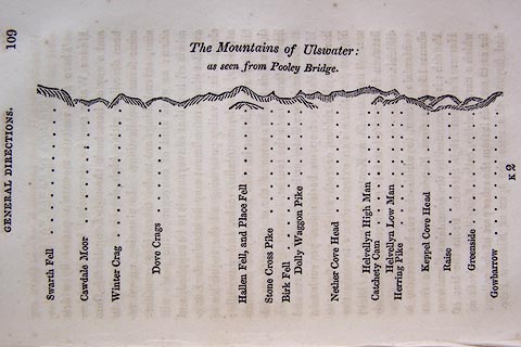 click to enlarge click to enlargeO75E05.jpg p.109 in A Concise Description of the English Lakes, by Jonathan Otley, 4th edition, 1830. "The Mountains of Ulswater: / as seen from Pooley Bridge." "Swarth Fell / Cawdale Moor / Winter Crag / Dove Crags / Hallen Fell, and Place Fell / Stone Cross Pike / Birk Fell / Dolly Waggon Pike / Nether Cove Head / Helvellyn High Man / Catchety Cam / Helvellyn Low Man / Herring Pike / Keppel Cove Head / Raise / Greenside / Gowbarrow" item:- Armitt Library : A1175.5 Image © see bottom of page |
|||||||||||||||||||||||||||||||||||||||||||||||||||||
|
|
||||||||||||||||||||||||||||||||||||||||||||||||||||||
| evidence:- | outline view:- Otley 1823 (4th edn 1830) placename:- Helvellyn Pile |
|||||||||||||||||||||||||||||||||||||||||||||||||||||
| source data:- | Print, engraving, outline view, Mountains of Patterdale as seen from the Slate Quarry
on Place Fell, published by Jonathan Otley, Keswick, Cumberland et al, 1830.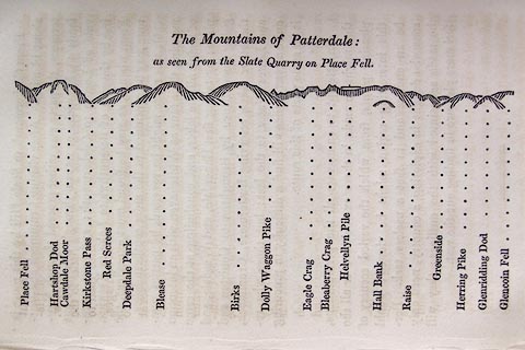 click to enlarge click to enlargeO75E10.jpg p.137 in A Concise Description of the English Lakes, by Jonathan Otley, 4th edition, 1830. "The Mountains of Patterdale: / as seen from the Slate Quarry on Place Fell." "Place Fell / Hartshop Dod / Cawdale Moor / Kirkstone Pass / Red Screes / Deepdale Park / Blease / Birks / Dolly Waggon Pike / Eagle Crag / Bleaberry Pike / Helvellyn Pile / Hall Bank / Raise / Greenside / Herring Pike / Glenridding Dod / Glencoin Fell" item:- Armitt Library : A1175.10 Image © see bottom of page |
|||||||||||||||||||||||||||||||||||||||||||||||||||||
|
|
||||||||||||||||||||||||||||||||||||||||||||||||||||||
| evidence:- | outline view:- Otley 1823 (8th edn 1849) placename:- Helvellyn |
|||||||||||||||||||||||||||||||||||||||||||||||||||||
| source data:- | Engraving, outline view of mountains, Grasmere from Red Bank Head, drawn by T Binns,
engraved by O Jewitt, opposite p.4 of A Descriptive Guide of the English Lakes, by
Jonathan Otley, 8th edition, 1849.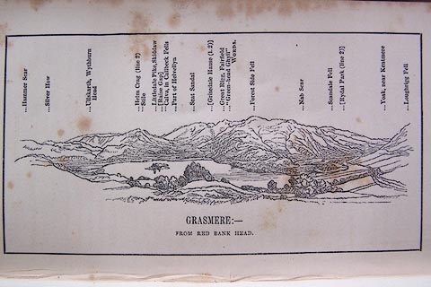 click to enlarge click to enlargeO80E04.jpg item:- Armitt Library : A1180.5 Image © see bottom of page |
|||||||||||||||||||||||||||||||||||||||||||||||||||||
|
|
||||||||||||||||||||||||||||||||||||||||||||||||||||||
| evidence:- | outline view:- Otley 1823 (8th edn 1849) placename:- Helvellyn High Man |
|||||||||||||||||||||||||||||||||||||||||||||||||||||
| source data:- | Engraving, outline view of mountains, Ullswater from Pooley Bridge, drawn by T Binns,
engraved by O Jewitt, opposite p.12 of A Descriptive Guide of the English Lakes, by
Jonathan Otley, 8th edition, 1849.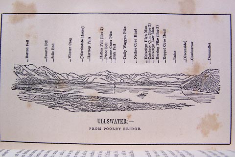 click to enlarge click to enlargeO80E07.jpg item:- Armitt Library : A1180.8 Image © see bottom of page |
|||||||||||||||||||||||||||||||||||||||||||||||||||||
|
|
||||||||||||||||||||||||||||||||||||||||||||||||||||||
| evidence:- | outline view:- Otley 1823 (8th edn 1849) placename:- Helvellyn Pile |
|||||||||||||||||||||||||||||||||||||||||||||||||||||
| source data:- | Engraving, outline view of mountains, Mountains of Patterdale from the Slate Quarry
on Place Fell, drawn by T Binns, engraved by O Jewitt, opposite p.14 of A Descriptive
Guide of the English Lakes, by Jonathan Otley, 8th edition, 1849.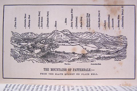 click to enlarge click to enlargeO80E08.jpg item:- Armitt Library : A1180.9 Image © see bottom of page |
|||||||||||||||||||||||||||||||||||||||||||||||||||||
|
|
||||||||||||||||||||||||||||||||||||||||||||||||||||||
| evidence:- | old text:- Otley 1823 (5th edn 1834) item:- bearings |
|||||||||||||||||||||||||||||||||||||||||||||||||||||
| source data:- | Guide book, A Concise Description of the English Lakes, the
mountains in their vicinity, and the roads by which they may be
visited, with remarks on the mineralogy and geology of the
district, by Jonathan Otley, published by the author, Keswick,
Cumberland now Cumbria, by J Richardson, London, and by Arthur
Foster, Kirkby Lonsdale, Cumbria, 1823; published 1823-49,
latterly as the Descriptive Guide to the English Lakes. goto source Page 79:- "STATION III.- HELVELLYN." Latitude 54° 31′ 43″ N. Longitude 3° 0′ 24″W. Height 3070 feet.
|
|||||||||||||||||||||||||||||||||||||||||||||||||||||
|
|
||||||||||||||||||||||||||||||||||||||||||||||||||||||
| evidence:- | descriptive text:- Ford 1839 (3rd edn 1843) placename:- Helvellyn item:- altitude, Helvellyn |
|||||||||||||||||||||||||||||||||||||||||||||||||||||
| source data:- | Guide book, A Description of Scenery in the Lake District, by
Rev William Ford, published by Charles Thurnam, Carlisle, by W
Edwards, 12 Ave Maria Lane, Charles Tilt, Fleet Street, William
Smith, 113 Fleet Street, London, by Currie and Bowman,
Newcastle, by Bancks and Co, Manchester, by Oliver and Boyd,
Edinburgh, and by Sinclair, Dumfries, 1839. goto source "... THE Lake district ... consists of large masses or clusters of mountains, generally terminating in one aspiring and pre-eminent point, with the intermediate valleys occupied either by lakes and their subsidiary tarns, or by winding rivers." "The chief nuclei of these clusters are, Skiddaw and Blencathra, Helvellyn, Fairfield, Coniston Old Man, Blackcomb, Scafell, Gable, Red Pike, Grasmoor, Grisdale Pike, and the Langdale Pikes. Many noble and commanding mountains rise around these, rivalling them in height and grandeur, but still" goto sourcePage iv:- "serving as large buttresses only. In the presentation of endlessly-diversified forms, these Mountains yield to none, however individually inferior they may be, owing to their being seldom seen in a detached point of view; although, on the other hand, they have thus the advantage of forming combinations at once grand and sublime, towering above each other, or rising in ridges, like the mighty billows of the ocean." goto sourcePage 45:- "..." "... The Horse Head inn is an excellent resting-place, and a guide, at a moderate charge, can be obtained here for the ascent of Helvellyn, which is most easily accomplished from this place. ..." goto sourcePage 46:- "At the very beginning of the ascent, there is a beautiful cascade on the stream, which is dashed down the steeps of Whelpside. The summit cannot be seen from the road, neither is the mountain itself seen anywhere to so much advantage as some others, from being crowded in on all sides by lofty compeers. Striding Edge and Swirrel stand on the east, Whelpside and Dolly Waggon Pike, with the Middle Tongue, on the west, embracing many noble eminences, beautiful villas, and sweet habitations, within their shadows. The ascent is long, but neither difficult nor dangerous. Arrived at the top, a vast tract of mountainous country is overlooked; the most prominent objects, and those seen with the greatest distinctness, are the lofty mountains as they point towards the sky. Behind these vast masses are hid many interesting scenes, while beneath and beyond are vistas of variously mingled landscapes, whose parts are indistinctly seen. Looking north, Skiddaw and Saddleback appear over Whiteside and Styx; at its foot are Keppel Cove Tarn and Red Tarn, on the edge of which Gough's remains, after having been watched over by his dog, 'through three months' space,' were accidentally found by a shepherd; the middle and lower reaches of Ulles Water and Place Fell on its borders; Angle Tarn and the Calcades (sic) falling towards Hartshope, which cannot itself be seen; and then the tops and ridges of St. Sunday Crag and Dolly Waggon Pike. Far away to the south," goto sourcePage 47:- "Windermere, Coniston, and Esthwaite, the Lancaster Sands, and Yorkshire mountains, fill the horizon; in the west, the Langdale Pikes and Wry Nose rise beyond Wythburn Head; the Scafell Pikes, with Great End and Lingmell, the Borrowdale mountains, Glaramara, and Great Gable, stand in bold relief against the sun's declining beams. The Derwent mountains complete the circle, the surface of Bassenthwaite glowing like burnished gold, and the lordly Criffel lifts his azure head over Solway's foaming tide. Helvellyn is three thousand and fifty-five feet above the level of the sea." goto sourcePage 148:- "pedestrian may follow up its stream, along bold water-breaks and falls, to a silent tarn in the recesses of Helvellyn," "'-- From the summit of whose craggy mound The perching eagle oft is heard to cry, Or on resounding wings to shoot athwart the sky.'" goto sourcePage 178:- "ELEVATION OF THE MOUNTAINS," "ACCORDING TO DIFFERENT AUTHORITIES."
|
|||||||||||||||||||||||||||||||||||||||||||||||||||||
|
|
||||||||||||||||||||||||||||||||||||||||||||||||||||||
| evidence:- | old map:- Ford 1839 map placename:- Helvellin |
|||||||||||||||||||||||||||||||||||||||||||||||||||||
| source data:- | Map, uncoloured engraving, Map of the Lake District of
Cumberland, Westmoreland and Lancashire, scale about 3.5 miles
to 1 inch, published by Charles Thurnam, Carlisle, and by R
Groombridge, 5 Paternoster Row, London, 3rd edn 1843.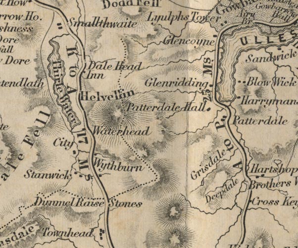 FD02NY31.jpg "Helvellin" Hill hachuring. item:- JandMN : 100.1 Image © see bottom of page |
|||||||||||||||||||||||||||||||||||||||||||||||||||||
|
|
||||||||||||||||||||||||||||||||||||||||||||||||||||||
| evidence:- | old map:- Garnett 1850s-60s H placename:- Helvellyn |
|||||||||||||||||||||||||||||||||||||||||||||||||||||
| source data:- | Map of the English Lakes, in Cumberland, Westmorland and
Lancashire, scale about 3.5 miles to 1 inch, published by John
Garnett, Windermere, Westmorland, 1850s-60s.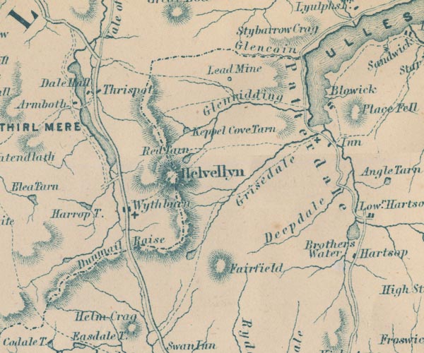 GAR2NY31.jpg "Helvellyn" hill hachuring item:- JandMN : 82.1 Image © see bottom of page |
|||||||||||||||||||||||||||||||||||||||||||||||||||||
|
|
||||||||||||||||||||||||||||||||||||||||||||||||||||||
| evidence:- | outline view:- Martineau 1855 |
|||||||||||||||||||||||||||||||||||||||||||||||||||||
| source data:- | Print, engraving, outline view, Mountains seen from the West Side of Thirlmere, drawn
by L Aspland, engraved by W Banks, Edinburgh, published by John Garnett, Windermere,
Westmorland, and by Whittaker and Co, London, 1855.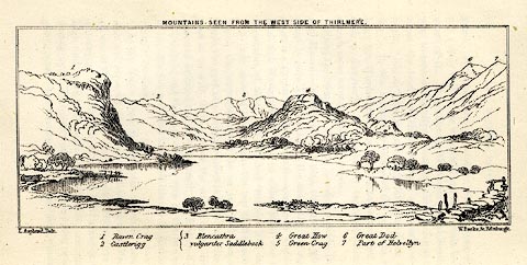 click to enlarge click to enlargeMNU110.jpg Opposite p.69 in A Complete Guide to the English Lakes, by Harriet Martineau. "MOUNTAINS SEEN FROM THE WEST SIDE OF THIRLMERE." "L Aspland Delt. / W Banks Sc Edinr." The view is captioned, numbers referring to mountains in the image:- "1 Raven Crag, 2 Castlerigg, 3 Blancathra vulgariter Saddleback, 4 Great How, 5 Green Crag, 6, Great Dod, 7 Part of Helvellyn." item:- Armitt Library : A1159.10 Image © see bottom of page |
|||||||||||||||||||||||||||||||||||||||||||||||||||||
|
|
||||||||||||||||||||||||||||||||||||||||||||||||||||||
| evidence:- | old text:- Martineau 1855 item:- altitude, Helvellyn; man; ghost story; ghost |
|||||||||||||||||||||||||||||||||||||||||||||||||||||
| source data:- | Guide book, A Complete Guide to the English Lakes, by Harriet
Martineau, published by John Garnett, Windermere, Westmorland,
and by Whittaker and Co, London, 1855; published 1855-76. goto source Page 99:- "... the tradition of the tramp of armies over Helvellyn, on the eve of the battle of Marston Moor. And now the tourist may proceed, - looking for ghosts, if he pleases, on Souter Fell." "..." goto sourcePage 165:- "... No mountain in the district is, we believe, so often climbed. Its central situation renders the view attractive on every account; it is very conspicuous; and it is not difficult of ascent. According to the Ordnance Surveyors, its height is 3,055 feet above the level of the sea; that is, 33 feet higher than Skiddaw, and rather more than 100 feet lower than Scawfell Pike. ... There are two cairns on two summits, not far apart, from between which, in an angle in the hill, the best view to the north is obtained. These Men, (as such piles of stones are called) mark the" goto sourcePage 166:- "dividing line between Cumberland and Westmorland. Northwards, the view is bounded by the Scotch mountains, with the Solway at their feet. Nearer stands Saddleback, with Skiddaw a little to the left. Kepel Cove Tarn lies below, with Catchedecam on the right. Eastwards, Red Tarn lies immediately below, between its two solemn precipices. Ullswater shines beyond, its nearer bank fringed by Gowbarrow Park; and Crossfell closes in the view afar. The Troutbeck mountains here peep over Striding Edge. Kirkstone and Fairfield rise to the south; and over the latter, there is a peep at Windermere, and sometimes, in clear weather, a glimpse of Lancaster Castle. Esthwaite Water and the sea in Morecambe Bay are seen at the same time. Blackcombe is caught sight of through Wrynose Gap; and the Coniston range and Langdale Pikes lead the eye round to the superior summits at the head of Wastdale and Buttermere. Even Honister Crag is seen, in a hollow, a little to the left of Cat Bells. Derwentwater is not seen: nor, from the higher Man, either Thirlmere or Bassenthwaite; though the two last are visible from the lower Man. Six lakes are seen, besides many tarns:- Ullswater, Windermere, Esthwaite Water, Coniston, Bassenthwaite and Thirlmere. Angle Tarn is particularly conspicuous, while its neighbour, Hays Water, is hidden in its hollow under High Street. The streams it sends down to Brothers' Water are however, very conspicuous when the sun is upon them." |
|||||||||||||||||||||||||||||||||||||||||||||||||||||
|
|
||||||||||||||||||||||||||||||||||||||||||||||||||||||
| evidence:- | old text:- Martineau 1855 item:- altitude, Helvellyn |
|||||||||||||||||||||||||||||||||||||||||||||||||||||
| source data:- | Guide book, A Complete Guide to the English Lakes, by Harriet
Martineau, published by John Garnett, Windermere, Westmorland,
and by Whittaker and Co, London, 1855; published 1855-76. goto source Page 179:- "A TABLE OF THE HEIGHTS OF MOUNTAINS IN THE COUNTIES OF CUMBERLAND, WESTMORLAND, AND LANCASHIRE." "No. : Names of Mountains. : Counties. : Height in Feet above the Sea Level." "3 : Helvellyn : Cumberland : 3055" |
|||||||||||||||||||||||||||||||||||||||||||||||||||||
|
|
||||||||||||||||||||||||||||||||||||||||||||||||||||||
| evidence:- | old print:- Walton 1876 placename:- Helvellyn |
|||||||||||||||||||||||||||||||||||||||||||||||||||||
| source data:- | Print, colour lithograph, Fresh Snow on Helvellyn, view near Oxenfell, Cumberland,
from a painting by Elijah Walton, published by W M Thompson, 20 Cockspur Street, Pall
Mall, and Burlington Gallery, Piccadilly, London, 1876.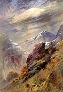 click to enlarge click to enlargeWLT309.jpg Plate 9 in English Lake Scenery, with a description by T G Bonney. item:- JandMN : 469.9 Image © see bottom of page |
|||||||||||||||||||||||||||||||||||||||||||||||||||||
|
|
||||||||||||||||||||||||||||||||||||||||||||||||||||||
| evidence:- | old print:- Walton 1876 placename:- Helvellyn |
|||||||||||||||||||||||||||||||||||||||||||||||||||||
| source data:- | Print, colour lithograph, Helvellyn, from above the Langdales, Westmorland/Cumberland,
from a painting by Elijah Walton, published by W M Thompson, 20 Cockspur Street, Pall
Mall, and Burlington Gallery, Piccadilly, London, 1876.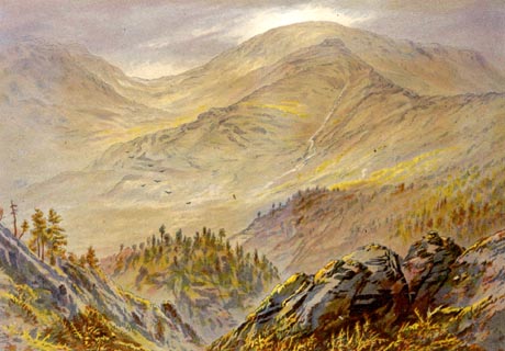 click to enlarge click to enlargeWLT320.jpg Plate 20 in English Lake Scenery, with a description by T G Bonney. item:- JandMN : 469.20 Image © see bottom of page |
|||||||||||||||||||||||||||||||||||||||||||||||||||||
|
|
||||||||||||||||||||||||||||||||||||||||||||||||||||||
| evidence:- | old photograph:- Bell 1880s-1940s |
|||||||||||||||||||||||||||||||||||||||||||||||||||||
| source data:- | Photograph, black and white, Helvellyn and Thirlmere, St John's Castlerigg and Wythburn,
Cumberland, by Herbert Bell, photographer, Ambleside, Westmorland, 1890s?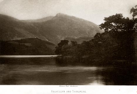 click to enlarge click to enlargeHB0951.jpg printed at bottom:- "Herbert Bell, Ambleside / HELVELLYN AND THIRLMERE" item:- Armitt Library : 1958.4256 Image © see bottom of page |
|||||||||||||||||||||||||||||||||||||||||||||||||||||
|
|
||||||||||||||||||||||||||||||||||||||||||||||||||||||
| evidence:- | old photograph:- Bell 1880s-1940s |
|||||||||||||||||||||||||||||||||||||||||||||||||||||
| source data:- | Photograph, sepia, Striding Edge, Helvellyn, Patterdale, Westmorland, by Herbert Bell,
photographer, Ambleside, Westmorland, 1890s.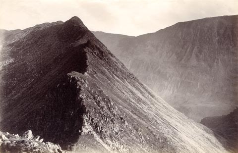 click to enlarge click to enlargeHB0871.jpg item:- Armitt Library : ALPS542 Image © see bottom of page |
|||||||||||||||||||||||||||||||||||||||||||||||||||||
|
|
||||||||||||||||||||||||||||||||||||||||||||||||||||||
| evidence:- | old photograph:- Bell 1880s-1940s |
|||||||||||||||||||||||||||||||||||||||||||||||||||||
| source data:- | Photograph, black and white, Helvellyn from Thirlmere, St John's Castlerigg and Wythburn,
Cumberland, by Herbert Bell, photographer, Ambleside, Westmorland, 1890s.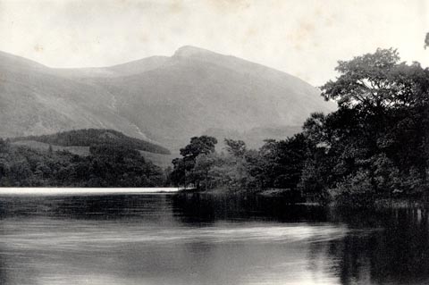 click to enlarge click to enlargeHB0605.jpg stamped on reverse:- "HERBERT BELL / Photographer / AMBLESIDE" item:- Armitt Library : ALPS265 Image © see bottom of page |
|||||||||||||||||||||||||||||||||||||||||||||||||||||
|
|
||||||||||||||||||||||||||||||||||||||||||||||||||||||
| evidence:- | old photograph:- Bell 1880s-1940s |
|||||||||||||||||||||||||||||||||||||||||||||||||||||
| source data:- | Photograph, black and white, Helvellyn and Striding Edge, Patterdale, Westmorland,
by Herbert Bell, photographer, Ambleside, Westmorland, 1890s.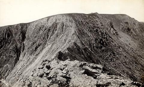 click to enlarge click to enlargeHB0602.jpg internegative at lower left:- "H. Bell" item:- Armitt Library : ALPS262 Image © see bottom of page |
|||||||||||||||||||||||||||||||||||||||||||||||||||||
|
|
||||||||||||||||||||||||||||||||||||||||||||||||||||||
| evidence:- | old photograph:- Bell 1880s-1940s item:- sunset |
|||||||||||||||||||||||||||||||||||||||||||||||||||||
| source data:- | Photograph, black and white, sunset over Helvellyn, St John's Castlerigg and Wythburn,
Cumberland, by Herbert Bell, photographer, Ambleside, Westmorland, 1890s. click to enlarge click to enlargeHB0607.jpg item:- Armitt Library : ALPS267 Image © see bottom of page |
|||||||||||||||||||||||||||||||||||||||||||||||||||||
|
|
||||||||||||||||||||||||||||||||||||||||||||||||||||||
| evidence:- | old photograph:- Bell 1880s-1940s |
|||||||||||||||||||||||||||||||||||||||||||||||||||||
| source data:- | Photograph, sepia, Wath Bridge and Helvellyn, Thirlmere, St John's Castlerigg and
Wythburn, Cumberland, by Herbert Bell, photographer, Ambleside, Westmorland, 1890s.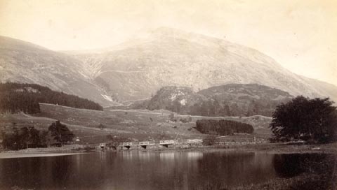 click to enlarge click to enlargeHB0729.jpg item:- Armitt Library : ALPS393 Image © see bottom of page |
|||||||||||||||||||||||||||||||||||||||||||||||||||||
|
|
||||||||||||||||||||||||||||||||||||||||||||||||||||||
| evidence:- | old print:- Philip/Wilson 1890s |
|||||||||||||||||||||||||||||||||||||||||||||||||||||
| source data:- | Print, engraving, Striding Edge and Red Tarn, Helvellyn,
published by George Philip and Son, London, Philip, Son and
Nephew, Liverpool, Lancashire, and Titus Wilson, Kendal,
Westmorland, about 1895.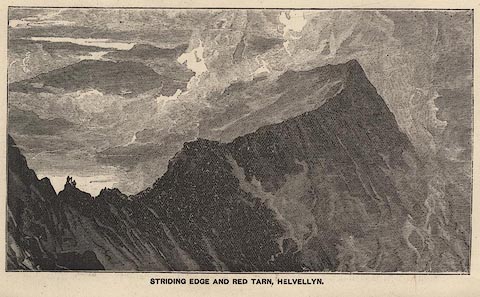 click to enlarge click to enlargePW1E25.jpg "STRIDING EDGE AND RED TARN, HELVELLYN." item:- JandMN : 58.26 Image © see bottom of page |
|||||||||||||||||||||||||||||||||||||||||||||||||||||
|
|
||||||||||||||||||||||||||||||||||||||||||||||||||||||
| evidence:- | old print:- Bradley 1901 placename:- Helvellyn |
|||||||||||||||||||||||||||||||||||||||||||||||||||||
| source data:- | Print, uncoloured lithograph, Helvellyn from Thirlmere, St John's Castlerigg and Wythburn,
Cumberland, by Joseph Pennell, published by Macmillan and Co, London, 1901.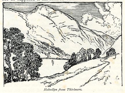 click to enlarge click to enlargeBRL163.jpg On page 244 of Highways and Byways in the Lake District, by A G Bradley. printed at bottom:- "Helvellyn from Thirlmere." item:- JandMN : 464.63 Image © see bottom of page |
|||||||||||||||||||||||||||||||||||||||||||||||||||||
|
|
||||||||||||||||||||||||||||||||||||||||||||||||||||||
| evidence:- | old print:- Brabant 1902 placename:- Helvellyn |
|||||||||||||||||||||||||||||||||||||||||||||||||||||
| source data:- | Print, uncoloured lithograph, Thirlmere and Helvellyn, St John's Castlerigg and Wythburn,
Cumberland, by Edmund H New, published by Methuen and Co, 36 Essex Street, Strand,
London, 1902.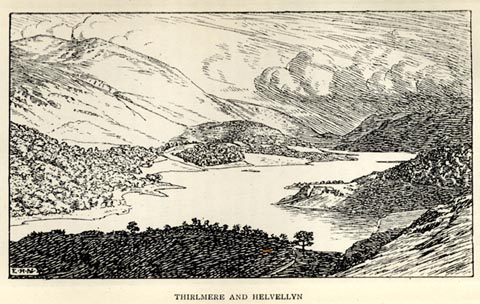 click to enlarge click to enlargeBBT107.jpg Tipped in opposite p.166 of The English Lakes, by F G Brabant. printed at bottom left:- "E. H. N" printed at bottom:- "THIRLMERE AND HELVELLYN" item:- JandMN : 502.12 Image © see bottom of page |
|||||||||||||||||||||||||||||||||||||||||||||||||||||
|
|
||||||||||||||||||||||||||||||||||||||||||||||||||||||
| evidence:- | old print:- Heaton Cooper 1905 (edn 1908) placename:- Helvellyn |
|||||||||||||||||||||||||||||||||||||||||||||||||||||
| source data:- | Print, colour halftone, Thirlmere and Helvellyn, St John's Castlerigg and Wythburn,
Cumberland, from a watercolour painting by Alfred Heaton Cooper, published by Adam
and Charles Black, London, 2nd edn 1908. click to enlarge click to enlargeHC0158.jpg Opposite p.168 of The English Lakes, painted by Alfred Heaton Cooper, described by William T Palmer. printed at tissue opposite the print:- "THIRLMERE AND HELVELLYN" printed at signed lower left:- "[A HEATON COOPER]" item:- JandMN : 468.58 Image © see bottom of page |
|||||||||||||||||||||||||||||||||||||||||||||||||||||
|
|
||||||||||||||||||||||||||||||||||||||||||||||||||||||
| evidence:- | text:- Mason 1907 (edn 1930) placename:- Monarch, The |
|||||||||||||||||||||||||||||||||||||||||||||||||||||
| source data:- | Text book, The Ambleside Geography Books bk.III, The Counties of
England, by Charlotte M Mason, published by Kegan Paul, Trench,
Trubner and Co, Broadway House, 68-74 Carter Lane, and the
Parents' Educational Union Office, 26 Victoria Street, London,
edn 1930. MSN1P020.txt Page 20:- "..." "... the vale narrows; the mountains become steep and rugged, with streams of boulders down their slopes; and. presently, we are under "the dark brow of the mighty Helvellyn."" "..." "HELVELLYN." "Helvellyn is the monarch of the lake mountains: Sca Fell is a hundred feet higher; Skiddaw, Sca Fell, and Helvellyn are all over 3000 feet; but neither of the others is such a big, swelling, giant of a mountain as Helvellyn." "We are too close to the Monarch to see his crown: our road lies under his vast shoulder; but we cannot pass him by. We must leave our box-seat [of out coach], and breast the hill, prepared for two or three hours' hard climbing." "The best way to see the mountain in its grandeur is to follow the track that leads up by the Red Tarn. ... two sloping walls of rock, the Striding Edge, and the Swirral Edge,- edges indeed, for they are simply steep, narrow, broken pathways on the top of each wall of rock. If you are a good climber, and not apt to become giddy," MSN1P021.txt Page 21:- "you may make your way up by one of these edges; but beware of a false step on either side of the narrow pathway; one such step, and you are plunged down a precipice of a hundred feet." "There is a touching tale of a traveller who attempted the passage on a snowy day and fell. Wordsworth tells the story in a poem beginning -" "" ""A barking sound the shepherd hears."" "On the summit of the mountain there is an awful stillness; not an insect hums in the air; we no longer hear the roar of the mountain torrents; not a blade of grass is to be seen; cushions, or tufts of moss, parched and brown, appear between the huge blocks and stones that lie in heaps on all sides; the snow lies here for half the year. now and then." |
|||||||||||||||||||||||||||||||||||||||||||||||||||||
|
|
||||||||||||||||||||||||||||||||||||||||||||||||||||||
| evidence:- | old print:- Reynolds 1915 placename:- Helvellyn |
|||||||||||||||||||||||||||||||||||||||||||||||||||||
| source data:- | Print, colour halftone, Thirlmere and Helvellyn, Cumberland, from a painting by Alfred
Heaton Cooper, published by Adam and Charles Black, London, 1915.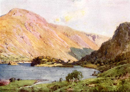 click to enlarge click to enlargeREY610.jpg "A HEATON COOPER" "THIRLMERE AND HELVELLYN" item:- JandMN : 1071.10 Image © see bottom of page |
|||||||||||||||||||||||||||||||||||||||||||||||||||||
|
|
||||||||||||||||||||||||||||||||||||||||||||||||||||||
| evidence:- | old text:- Burrow 1920s placename:- |
|||||||||||||||||||||||||||||||||||||||||||||||||||||
| source data:- | Road book, strip maps with parts in Westmorland, Cumberland etc,
irregular scales about 1.5 miles to 1 inch, by E J Burrow and
Co, Cheltenham, Gloucestershire, 1920s. "... [by Thirlmere] Close at hand on the right mighty Helvellyn lifts its proud peak 3,118 feet above sea level, the chief of a long backbone of mountains. ..." |
|||||||||||||||||||||||||||||||||||||||||||||||||||||
|
|
||||||||||||||||||||||||||||||||||||||||||||||||||||||
| hearsay:- |
Between 1805 and 1823, John Dalton climbed Helvellyn every July to carry out experiments
on humidity, using snow as his cooling agent. He always found snow |
|||||||||||||||||||||||||||||||||||||||||||||||||||||
| "in the usual place, about a quarter of a mile north of the summit." |
||||||||||||||||||||||||||||||||||||||||||||||||||||||
|
|
||||||||||||||||||||||||||||||||||||||||||||||||||||||
| hearsay:- |
On a cold, wintry day, 22 December 1926? John Leeming lands his Avro Gosport plane
on the top of the mountain using the strong wind to stop abruptly on the summit -
surprising a lone walker. |
|||||||||||||||||||||||||||||||||||||||||||||||||||||
|
|
||||||||||||||||||||||||||||||||||||||||||||||||||||||
| evidence:- | outline view:- Baddeley 1930s |
|||||||||||||||||||||||||||||||||||||||||||||||||||||
| source data:- | Print, lithograph, Panoramic View from Summit of Helvellyn, engraved by John Bartholomew
and Co, Edinburgh, published by Ward, Lock and Co, Warwick House, Salisbury Square,
London, 1930s.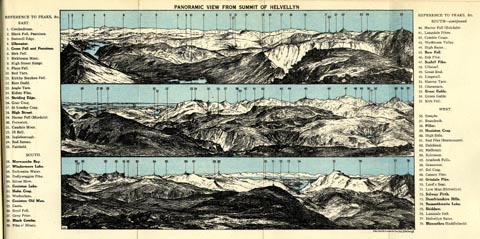 click to enlarge click to enlargeBE01E3.jpg item:- JandMN : 305.3 Image © see bottom of page |
|||||||||||||||||||||||||||||||||||||||||||||||||||||
|
|
||||||||||||||||||||||||||||||||||||||||||||||||||||||
| evidence:- | old print:- MacBride 1922 placename:- Helvellyn |
|||||||||||||||||||||||||||||||||||||||||||||||||||||
| source data:- | Print, colour, Striding Edge, Helvellyn, by Alfred Heaton Cooper, published by Adam
and Charles Black, 4-6 Soho Square, London, 2nd edn 1928.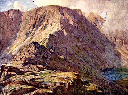 click to enlarge click to enlargeMB0125.jpg Tipped in opposite p.172 in Wild Lakeland by MacKenzie MacBride. printed at bottom:- "STRIDING EDGE, HELVELLYN" signed at lower right:- "A. HEATON COOPER" item:- JandMN : 195.27 Image © see bottom of page |
|||||||||||||||||||||||||||||||||||||||||||||||||||||
|
|
||||||||||||||||||||||||||||||||||||||||||||||||||||||
| evidence:- | outline view:- LMS 1920s |
|||||||||||||||||||||||||||||||||||||||||||||||||||||
| source data:- | Hills from Penrith Station, published in the LMS Route Book No.3, The Track of the
Royal Scot, by the London, Midland and Scottish Railway, LMS, 1920s.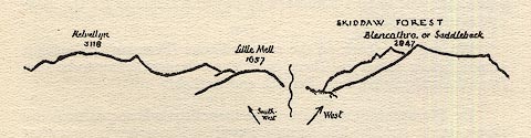 click to enlarge click to enlargeLS1E40.jpg item:- JandMN : 95.13 Image © see bottom of page |
|||||||||||||||||||||||||||||||||||||||||||||||||||||
|
|
||||||||||||||||||||||||||||||||||||||||||||||||||||||
| evidence:- | old photograph:- Bogg 1898 placename:- Helvellyn |
|||||||||||||||||||||||||||||||||||||||||||||||||||||
| source data:- | Photograph, halftone print, Red Tarn, Helvellyn, St John's Castlerigg and Wythburn,
Cumbria, by W G Foster, published by Edmund Bogg, 3 Woodhouse Lane, and James Miles,
Guildford Street, Leeds, Yorkshire, 1898.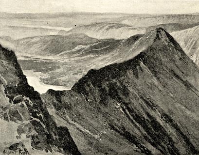 click to enlarge click to enlargeBGG160.jpg Included on p.172 of Lakeland and Ribblesdale, by Edmund Bogg. item:- JandMN : 231.60 Image © see bottom of page |
|||||||||||||||||||||||||||||||||||||||||||||||||||||
|
|
||||||||||||||||||||||||||||||||||||||||||||||||||||||
| evidence:- | outline view:- Jenkinson 1875 placename:- Helvellyn |
|||||||||||||||||||||||||||||||||||||||||||||||||||||
| source data:- | Print, lithograph, outline view, Panoramic Sketches from Helvellyn, Westmorland, by
Edwin A Pettitt, London, published by Edward Stanford, 55 Charing Cross, London, 1875. click to enlarge click to enlargeJk01E1.jpg "... Helvellyn ..." item:- JandMN : 28.5 Image © see bottom of page |
|||||||||||||||||||||||||||||||||||||||||||||||||||||
|
|
||||||||||||||||||||||||||||||||||||||||||||||||||||||
| evidence:- | outline view:- Jenkinson 1875 placename:- Helvellyn |
|||||||||||||||||||||||||||||||||||||||||||||||||||||
| source data:- | Print, lithograph, outline view, Panoramic Sketches from Skiddaw, Cumberland, by Edwin
A Pettitt, London, published by Edward Stanford, 55 Charing Cross, London, 1875. click to enlarge click to enlargeJk01E2.jpg "... Helvellyn ..." item:- JandMN : 28.8 Image © see bottom of page |
|||||||||||||||||||||||||||||||||||||||||||||||||||||
|
|
||||||||||||||||||||||||||||||||||||||||||||||||||||||
| evidence:- | outline view:- Jenkinson 1875 placename:- Helvellyn |
|||||||||||||||||||||||||||||||||||||||||||||||||||||
| source data:- | Print, lithograph, outline view, Panoramic Sketches from Scawfell Pike, Cumberland,
by Edwin A Pettitt, London, published by Edward Stanford, 55 Charing Cross, London,
1875. click to enlarge click to enlargeJk01E3.jpg "... Helvellyn ..." item:- JandMN : 28.9 Image © see bottom of page |
|||||||||||||||||||||||||||||||||||||||||||||||||||||
|
|
||||||||||||||||||||||||||||||||||||||||||||||||||||||
| evidence:- | outline view:- Matthew 1866 placename:- Helvellyn |
|||||||||||||||||||||||||||||||||||||||||||||||||||||
| source data:- | Print, engraving, outline view, Helvellyn from above Harrop Tarn, Poney Road from
Wythburn to Whatendlath and Borrowdale, Cumberland, published by J Richardson, Highgate,
Kendal, Westmorland, 1866.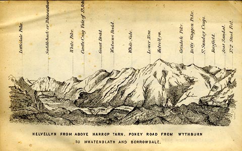 click to enlarge click to enlargeMW1E02.jpg Tipped in before p.1 of The English Lakes, Peaks and Passes, from Kendal to Keswick, by George King Matthew. printed at bottom:- "HELVELLYN FROM ABOVE HARROP TARN, PONEY ROAD FROM WYTHBURN TO WHATENDLATH AND BORROWDALE." printed at caption to mountains:- "... Helvellyn. ..." item:- Armitt Library : A1168.2 Image © see bottom of page |
|||||||||||||||||||||||||||||||||||||||||||||||||||||
|
|
||||||||||||||||||||||||||||||||||||||||||||||||||||||
| evidence:- | old print:- Prior 1865 placename:- Helvellyn |
|||||||||||||||||||||||||||||||||||||||||||||||||||||
| source data:- | Print, uncoloured engraving, Helvellyn from Harrop Tarn, St John's Castlerigg and
Wythburn, Cumberland, published by John Garnett, Windermere, Westmorland, and by Simpkin,
Marshall and Co, London, 1865.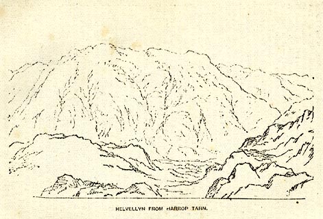 click to enlarge click to enlargePI0108.jpg Included on page 62 of the guide book, Ascents and Passes in the Lake District of England, by Herman Prior. printed at bottom:- "HELVELLYN FROM HARROP TARN." item:- JandMN : 235.10 Image © see bottom of page |
|||||||||||||||||||||||||||||||||||||||||||||||||||||
|
|
||||||||||||||||||||||||||||||||||||||||||||||||||||||
| evidence:- | outline view:- Black 1856 (23rd edn 1900) placename:- Helvellyn |
|||||||||||||||||||||||||||||||||||||||||||||||||||||
| source data:- | Print, lithograph, Outline Views, Ullswater - Mountains as seen a little on the Matterdale
Road near Lyulph's Tower on Ullswater, and Mountains as seen at the Slate Quarry at
Blowick on Ullswater, by J Flintoft, Keswick, Cumberland, engraved by R Mason, Edinburgh,
Lothian, about 1900.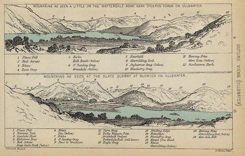 click to enlarge click to enlargeBC08E2.jpg "... 14 Helvellyn ..." item:- JandMN : 37.8 Image © see bottom of page |
|||||||||||||||||||||||||||||||||||||||||||||||||||||
|
|
||||||||||||||||||||||||||||||||||||||||||||||||||||||
| evidence:- | outline view:- Black 1856 (23rd edn 1900) placename:- Helvellyn |
|||||||||||||||||||||||||||||||||||||||||||||||||||||
| source data:- | Print, lithograph, Outline Views, Grasmere and Coniston - Mountains as seen from Redbank,
Grasmere, and Mountains as seen a little beyond Tent Lodge on the Road from Coniston
to Ulverstone, by J Flintoft, Keswick, Cumberland, engraved by R Mason, Edinburgh,
Lothian, about 1900.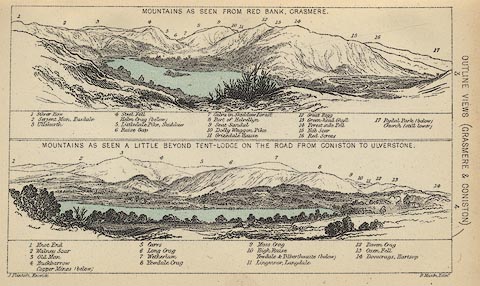 click to enlarge click to enlargeBC08E3.jpg "... 8 Part of Helvellyn ..." item:- JandMN : 37.12 Image © see bottom of page |
|||||||||||||||||||||||||||||||||||||||||||||||||||||
|
|
||||||||||||||||||||||||||||||||||||||||||||||||||||||
| evidence:- | outline view:- Black 1841 (3rd edn 1846) placename:- Helvellyn |
|||||||||||||||||||||||||||||||||||||||||||||||||||||
| source data:- | Print, engraving, outline view, Mountains as seen from Red Bank, Grasmere, and Mountains
as seen a little beyond Tent-Lodge on the Road from Coniston to Ulverston, by J Flintoft,
Keswick, Cumberland, engraved by R Mason, Edinburgh, Lothian, about 1846.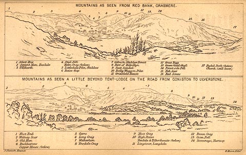 click to enlarge click to enlargeBC02E3.jpg "... 8 Part of Helvellyn ..." item:- JandMN : 32.5 Image © see bottom of page |
|||||||||||||||||||||||||||||||||||||||||||||||||||||
|
|
||||||||||||||||||||||||||||||||||||||||||||||||||||||
| evidence:- | outline view:- Black 1841 (3rd edn 1846) placename:- Helvellyn |
|||||||||||||||||||||||||||||||||||||||||||||||||||||
| source data:- | Print, engraving, outline view, Mountains as seen a little on the Matterdale Road
near Lyulph's Tower on Ulleswater, and Mountains as seen at the Slate Quarry at Blowick
on Ulleswater, by J Flintoft, Keswick, Cumberland, engraved by R Mason, Edinburgh,
Lothian, about 1846.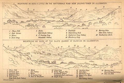 click to enlarge click to enlargeBC02E9.jpg "... 14 Helvellyn ..." item:- JandMN : 32.15 Image © see bottom of page |
|||||||||||||||||||||||||||||||||||||||||||||||||||||
|
|
||||||||||||||||||||||||||||||||||||||||||||||||||||||
| evidence:- | outline view:- Tattersall 1836 placename:- Helvellyn |
|||||||||||||||||||||||||||||||||||||||||||||||||||||
| source data:- | Print, engraving, View from Skiddaw, looking South, Cumberland, Westmorland and Lancashire,
drawn by George Tattersall, engraved by W F Topham, published by Sherwood and Co,
Paternoster Row, London, about 1836.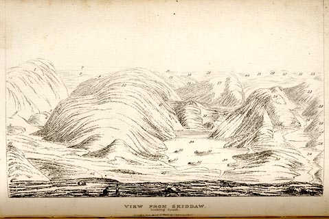 click to enlarge click to enlargeTAT137.jpg The print is captioned with mountain names and acts as an outline view. Tipped in opposite p.91 of The Lakes of England, by George Tattersall. printed at bottom:- "VIEW FROM SKIDDAW, / looking South. / [London Pubd. ...]" printed at p.91:- "... FOUR VIEWS FROM THE SUMMIT OF SKIDDAW. III. LOOKING SOUTH. / 1. Helvellyn, Cumberland. / ..." item:- Armitt Library : A1204.38 Image © see bottom of page |
|||||||||||||||||||||||||||||||||||||||||||||||||||||
|
|
||||||||||||||||||||||||||||||||||||||||||||||||||||||
| evidence:- | outline view:- Tattersall 1836 placename:- Helvellyn |
|||||||||||||||||||||||||||||||||||||||||||||||||||||
| source data:- | Print, engraving, Thirlmere from Raysgap, Cumberland, drawn by George Tattersall,
engraved by W F Topham, published by Sherwood and Co, Paternoster Row, London, about
1836.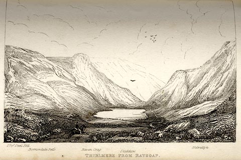 click to enlarge click to enlargeTAT117.jpg The print is captioned with mountain names and acts as an outline view. Tipped in opposite p.54 of The Lakes of England, by George Tattersall. printed at bottom:- "THIRLMERE FROM RAYSGAP." printed at bottom left to right:- "Pt. of Steel Fell. / Borrowdale Fells. / Raven Crag. / Skiddaw. / Helvellyn." item:- Armitt Library : A1204.18 Image © see bottom of page |
|||||||||||||||||||||||||||||||||||||||||||||||||||||
|
|
||||||||||||||||||||||||||||||||||||||||||||||||||||||
| evidence:- | old print:- Rose 1832-35 (vol.3 no.3) placename:- Helvellyn item:- road |
|||||||||||||||||||||||||||||||||||||||||||||||||||||
| source data:- | Print, uncoloured engraving, Helvellyn, from the North West, Cumberland, drawn by
Thomas Allom, engraved by R Sands, published by Fisher, Son and Co, London, 1835.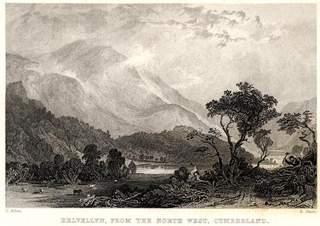 click to enlarge click to enlargePR0664.jpg vol.3 pl.3 in the set of prints, Westmorland, Cumberland, Durham and Northumberland Illustrated. printed at bottom left, right, centre:- "T. Allom. / R. Sands. / HELLVELYN, FROM THE NORTH WEST, CUMBERLAND." item:- Dove Cottage : 2008.107.605 Image © see bottom of page |
|||||||||||||||||||||||||||||||||||||||||||||||||||||
|
|
||||||||||||||||||||||||||||||||||||||||||||||||||||||
 ascent 1780s ascent 1780s |
||||||||||||||||||||||||||||||||||||||||||||||||||||||
|
|
||||||||||||||||||||||||||||||||||||||||||||||||||||||
| ascent 1800s |
||||||||||||||||||||||||||||||||||||||||||||||||||||||
|
|
||||||||||||||||||||||||||||||||||||||||||||||||||||||
| ascent 1855 |
||||||||||||||||||||||||||||||||||||||||||||||||||||||
|
|
||||||||||||||||||||||||||||||||||||||||||||||||||||||
| evidence:- | old print:- Gresham Publishing 1900s placename:- Helvellyn |
|||||||||||||||||||||||||||||||||||||||||||||||||||||
| source data:- | Print, colour halftone, Thirlmere and Helvellyn, Cumberland, by Ernest W Haslehurst,
published by The Gresham Publishing Co, 66 Chandos Street, London, 1900s?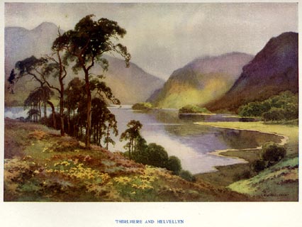 click to enlarge click to enlargePR1563.jpg Tipped in opposite p.20 of The English Lakes section of a volume of Our Beautiful Homeland. printed at bottom:- "THIRLMERE AND HELVELLYN" printed at lower right:- "E. W. HASLEHURST" item:- JandMN : 381.5 Image © see bottom of page |
|||||||||||||||||||||||||||||||||||||||||||||||||||||
|
|
||||||||||||||||||||||||||||||||||||||||||||||||||||||
| evidence:- | old print:- Goodwin 1887 (edn 1890) placename:- Helvellyn |
|||||||||||||||||||||||||||||||||||||||||||||||||||||
| source data:- | Print, etching? Helvellyn, Westmorland, by Harry Goodwin, published by Swan Sonnenschein
and Co, Paternoster Square, London, 1890.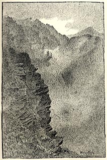 click to enlarge click to enlargePR1598.jpg Tipped in opposite p.142 of Through the Wordsworth Country, by William Knight. printed at lower right:- "Helvellyn" item:- JandMN : 382.28 Image © see bottom of page |
|||||||||||||||||||||||||||||||||||||||||||||||||||||
|
|
||||||||||||||||||||||||||||||||||||||||||||||||||||||
| evidence:- | old print:- Sylvan 1847 placename:- Helvellyn |
|||||||||||||||||||||||||||||||||||||||||||||||||||||
| source data:- | Print, engraving, Helvellyn, from Bull Crags, Cumberland, published by John Johnstone,
Paternoster Row, London, et al, 1847.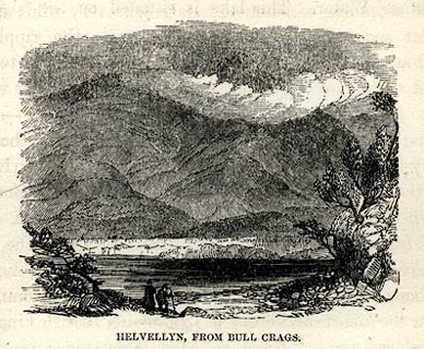 click to enlarge click to enlargeSYL138.jpg On p.153 of Sylvan's Pictorial Guide to the English Lakes. printed at bottom:- "HELVELLYN, FROM BULL CRAGS." item:- Armitt Library : A1201.38 Image © see bottom of page |
|||||||||||||||||||||||||||||||||||||||||||||||||||||
|
|
||||||||||||||||||||||||||||||||||||||||||||||||||||||
| evidence:- | outline view:- Tattersall 1836 (version 1869) placename:- Helvellyn |
|||||||||||||||||||||||||||||||||||||||||||||||||||||
| source data:- | Print, hand coloured, Thirlmere, from the North, Cumberland, drawn by George Tattersall,
1836, engraved by W F Topham, published by T J Allman, 463 Oxford Street, London,
1869.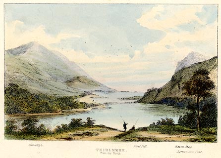 click to enlarge click to enlargeTAT207.jpg Included in The Lakes of England, by W F Topham. printed at bottom:- "THIRLMERE, / from the North." printed at bottom:- "Helvellyn. / Steel Fell. / Raven Crag. / Borrowdale Fells." item:- Armitt Library : A1067.7 Image © see bottom of page |
|||||||||||||||||||||||||||||||||||||||||||||||||||||
|
|
||||||||||||||||||||||||||||||||||||||||||||||||||||||
| evidence:- | outline view:- Tattersall 1836 placename:- Helvellyn item:- panorama |
|||||||||||||||||||||||||||||||||||||||||||||||||||||
| source data:- | Print, engraving, View from Helvellyn, looking North, Cumberland and Westmorland,
drawn by George Tattersall, engraved by W F Topham, published by Sherwood and Co,
Paternoster Row, London, about 1836.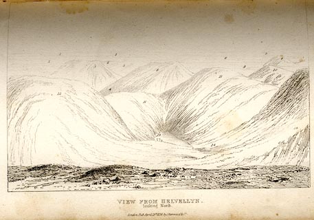 click to enlarge click to enlargeTAT121.jpg Tipped in opposite p.68 of The Lakes of England, by George Tattersall. printed at bottom:- "VIEW FROM HELVELLYN. / looking North." printed at p.68:- "... VIEW FROM THE SUMMIT OF HELVELLYN. I. LOOKING NORTH. / 1. Scotch Mountains. / 2. Solway Frith. / 3. Skiddaw, Cumberland. / 4. Thelcot Vale, Cumberland. / 5. Saddleback, Cumberland. / 6. Scilly Bank, Cumberland. / 7. Matterdale, Westmoreland. / 8. Dodd Fell, Westmoreland. / 9. Grisedale Fell, Cumberland. / 10. Greenside, Cumberland. / 11. Catsedecam, Cumberland. / 12. Helvellyn Top, Westmoreland. / 13. Keppel Cove Tarn, Westmoreland. / 14. Swirrel Edge, Westmoreland." item:- Armitt Library : A1204.22 Image © see bottom of page |
|||||||||||||||||||||||||||||||||||||||||||||||||||||
|
|
||||||||||||||||||||||||||||||||||||||||||||||||||||||
| evidence:- | outline view:- Tattersall 1836 placename:- Helvellyn item:- panorama |
|||||||||||||||||||||||||||||||||||||||||||||||||||||
| source data:- | Print, engraving, View from Helvellyn, looking East, Cumberland and Westmorland, drawn
by George Tattersall, engraved by W F Topham, published by Sherwood and Co, Paternoster
Row, London, about 1836.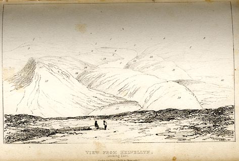 click to enlarge click to enlargeTAT122.jpg Tipped in opposite p.68 of The Lakes of England, by George Tattersall. printed at bottom:- "VIEW FROM HELVELLYN. / looking East." printed at p.68:- "... VIEW FROM THE SUMMIT OF HELVELLYN. II. LOOKING EAST. / 1. Matterdale, Westmoreland. / 2. Martindale, Westmoreland. / 3. Dodd Fell, Cumberland. / 4. High Row, Cumberland. / 5. Stybarrow Crag, Westmorel. / 6. Ullswater. / 7. Swarth Fell, Westmoreland. / 8. Kidsay Pike, Cumberland. / 9. Harter Fell, Westmoreland. / 10. Cross Fell, Westmoreland. / 11. Beck Fell, Westmoreland. / 12. Thrang Crag, Westmoreland. / 13. Place Fell, Westmoreland. / 14. Glenridding, Westmoreland. / 15. Gowbarrow Parks, Cumberland. / 16. Black Coomb, Cumberland. / 17. Swirrel Edge, Westmorel. / 18. Red Tarn, Westmoreland. / 19. Striding Edge, Westmorel." item:- Armitt Library : A1204.23 Image © see bottom of page |
|||||||||||||||||||||||||||||||||||||||||||||||||||||
|
|
||||||||||||||||||||||||||||||||||||||||||||||||||||||
| evidence:- | outline view:- Tattersall 1836 placename:- Helvellyn item:- panorama |
|||||||||||||||||||||||||||||||||||||||||||||||||||||
| source data:- | Print, engraving, View from Helvellyn, looking South, Westmorland and Lancashire,
drawn by George Tattersall, engraved by W F Topham, published by Sherwood and Co,
Paternoster Row, London, about 1836.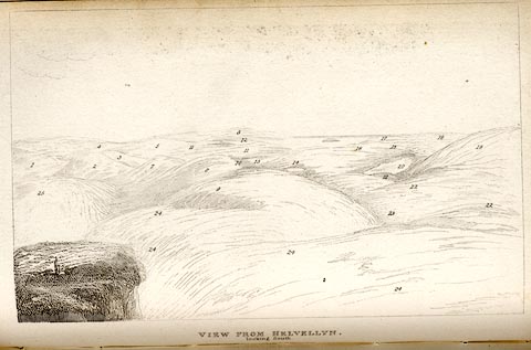 click to enlarge click to enlargeTAT123.jpg Tipped in opposite p.69 of The Lakes of England, by George Tattersall. printed at bottom:- "VIEW FROM HELVELLYN. / looking South." printed at p.68:- "... VIEW FROM THE SUMMIT OF HELVELLYN. III. LOOKING SOUTH. / 1. High Street, Westmoreland. / 2. Scandale, Westmoreland. / 3. Hill Bell, Westmoreland. / 4. Long Sleddale, Westmorel. / 5. Shap Fells, Westmoreland. / 6. Arnside Fells, Lancashire. / 7. Kirkstone, Westmoreland. / 8. Fairfield, Westmoreland. / 9. Dolly Waggon Pike, Westmoreland. / 10. Loughrigg Fell, Westmoreland. / 11. Cartmell Fell, Lancashire. / 12. Morecambe Bay. / 13. Windermere Lake, Westmoreland and Lancashire. / 14. Esthwaite Water, Lancashire. / 15. Nibthwaite Fells, Lancash. / 16. High Birch, Lancashire. / 17. Foulsha, Westmoreland. / 18. Grange Fells, Lancashire. / 19. Coniston Old Man, Lancash. / 20. Coniston Lake, Lancashire. / 21. Hawkshead Moor, Lancash. / 22. Graythorte, Lancashire. / 23. Wernfell, Lancashire. / 24. Helvellyn, Cumberland. / 25. Striding Egde, Westmoreland." item:- Armitt Library : A1204.24 Image © see bottom of page |
|||||||||||||||||||||||||||||||||||||||||||||||||||||
|
|
||||||||||||||||||||||||||||||||||||||||||||||||||||||
| evidence:- | outline view:- Tattersall 1836 placename:- Helvellyn item:- panorama |
|||||||||||||||||||||||||||||||||||||||||||||||||||||
| source data:- | Print, engraving, View from Helvellyn, looking West, Westmorland, Cumberland and Lancashire,
drawn by George Tattersall, engraved by W F Topham, published by Sherwood and Co,
Paternoster Row, London, about 1836.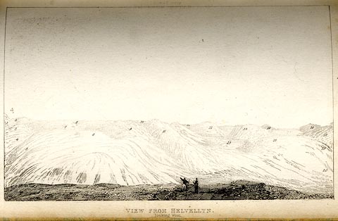 click to enlarge click to enlargeTAT124.jpg Tipped in opposite p.69 of The Lakes of England, by George Tattersall. printed at bottom:- "VIEW FROM HELVELLYN. / looking West." printed at p.68:- "... VIEW FROM THE SUMMIT OF HELVELLYN. IV. LOOKING WEST. / 1. Coniston Fells, Lancashire. / 2. Black Combe, Cumberland. / 3. Lingmire, Westmoreland. / 4. Blakerigg, Westmoreland. / 5. Deer Bells, Westmoreland. / 6. Langdale PIkes, Westmorel. / 7. Bow Fell, Westmoreland and Cumberland. / 8. Wilbeck, Cumberland. / 9. Scawfell and Scawfell Pike, Cumberland. / 10. Muncaster Fell, Cumberland. / 11. Great End, Cumberland. / 12. Great Gavel, Cumberland. / 13. Honiston Crag, Cumberland. / 14. Cat Bells, Cumberland. / 15. Grange Fell, Cumberland. / 16. Red Pike, Cumberland. / 17. Robinson, Cumberland. / 18. Grasmoor, Cumberland. / 19. Causey Pike, Cumberland. / 20. Vale of Newlands, Cumberl. / 21. Whiteless Pike, Cumberland. / 22. Pillar, Cumberland." item:- Armitt Library : A1204.25 Image © see bottom of page |
|||||||||||||||||||||||||||||||||||||||||||||||||||||
|
|
||||||||||||||||||||||||||||||||||||||||||||||||||||||
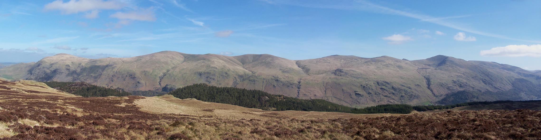 Click to enlarge BUI66.jpg Panorama - Clough Head, Great Dodd, Watson's Dodd, Stybarrow Dodd, Whiteside, Helvellyn. (taken 7.4.2011) 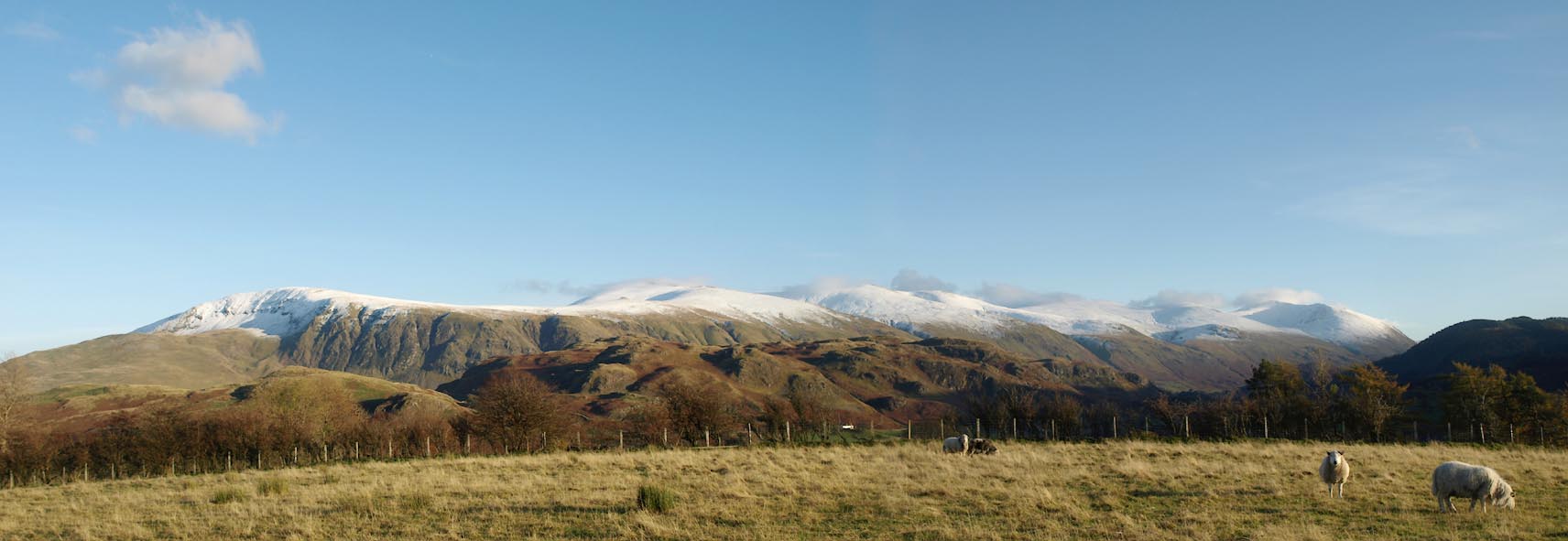 Click to enlarge BXP71.jpg Panorama - Clough Head, Great Dodd, Watson's Dodd, Stybarrow Dodd, Whiteside, Helvellyn. (taken 4.11.2012) 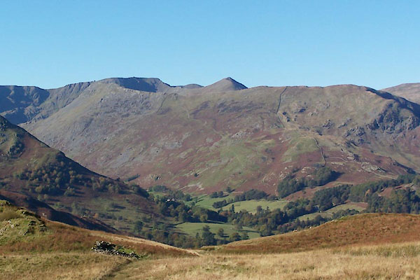 BTS67.jpg From about Boredale Hause; Catstye Cam poking up behind Striding Edge. (taken 20.10.2010) 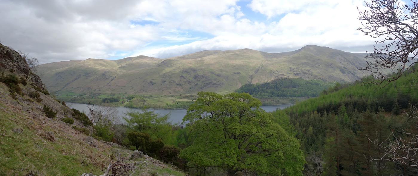 Click to enlarge BYJ43.jpg The Dodds and Helvellyn range. (taken 22.5.2013) 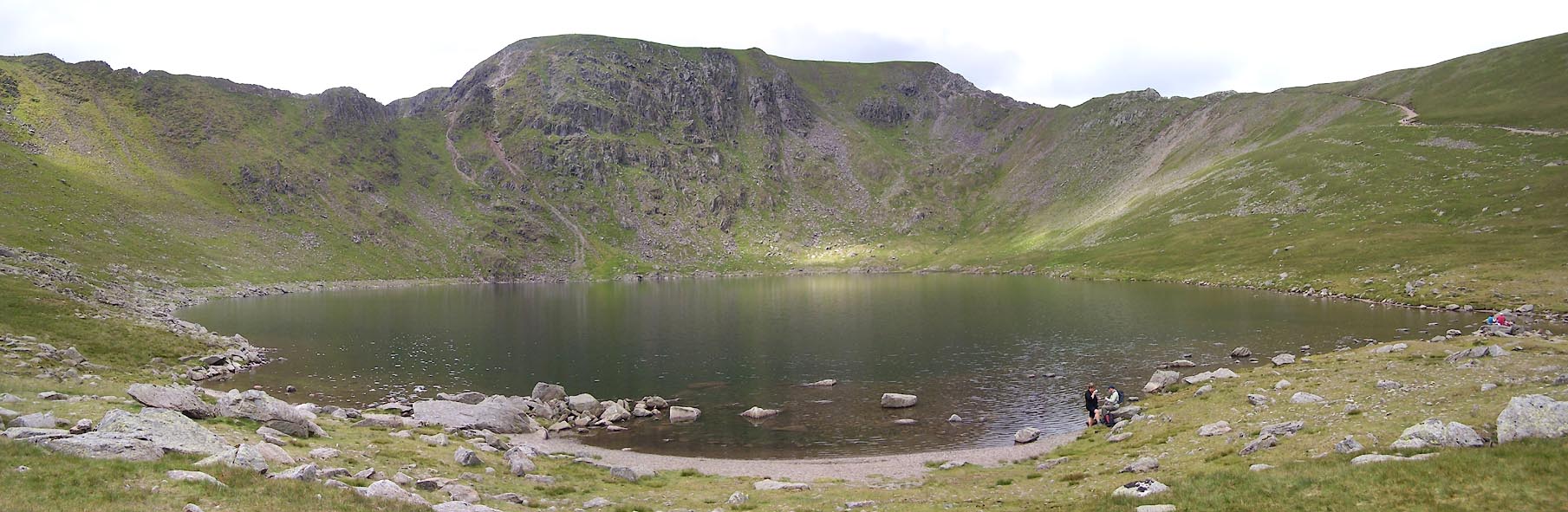 Click to enlarge BUU96.jpg Red Tarn in front. (taken 20.6.2011) 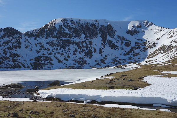 CET40.jpg Red Tarn in front. (taken 14.3.2016) 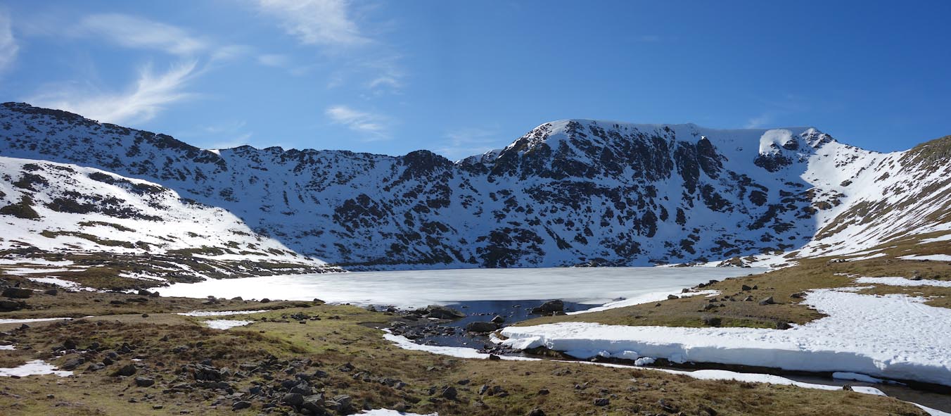 Click to enlarge CET41.jpg Red Tarn in front. (taken 14.3.2016) 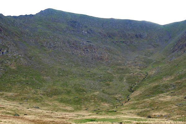 CCD38.jpg The summit above Brown Cove. (taken 18.11.2014) |
||||||||||||||||||||||||||||||||||||||||||||||||||||||
|
|
||||||||||||||||||||||||||||||||||||||||||||||||||||||
| notes:- |
This mountain is a 'Furth Munro'. |
|||||||||||||||||||||||||||||||||||||||||||||||||||||
|
|
||||||||||||||||||||||||||||||||||||||||||||||||||||||
| hearsay:- |
You might see a Brocken Spectre from the top of Helvellyn, when a low sun casts your
shadow on mist lying below. The shadow is exactly your size, but the effect of perspective
makes the shadow, at a distance, appear huge. |
|||||||||||||||||||||||||||||||||||||||||||||||||||||
|
|
||||||||||||||||||||||||||||||||||||||||||||||||||||||
| hearsay:- |
John Dalton, the scientist, climbed Helvellyn once a year for about forty years:- |
|||||||||||||||||||||||||||||||||||||||||||||||||||||
| "... to bring into exercise a set of muscles which would otherwise have grown stiff." |
||||||||||||||||||||||||||||||||||||||||||||||||||||||
| Once, caught in mist, they were slowly descending when Dalton exclaimed:- |
||||||||||||||||||||||||||||||||||||||||||||||||||||||
| "Not one step more! There is nothing but mist to tread on!" |
||||||||||||||||||||||||||||||||||||||||||||||||||||||
| Saving the party on the cliff above Red Tarn. |
||||||||||||||||||||||||||||||||||||||||||||||||||||||
|
|
||||||||||||||||||||||||||||||||||||||||||||||||||||||
Lakes Guides menu.