 Old Cumbria Gazetteer
 |
 |
|
| Greenburn Mine, Coniston | ||
| Greenburn Mine | ||
| New Coniston Mine | ||
| Great Coniston Mine | ||
| site name:- | Greenburn Beck | |
| locality:- | Greenburn | |
| civil parish:- | Coniston (formerly Lancashire) | |
| county:- | Cumbria | |
| locality type:- | copper mine | |
| locality type:- | mine | |
| coordinates:- | NY290022 | |
| 1Km square:- | NY2902 | |
| 10Km square:- | NY20 | |
| references:- | Adams, John: 1988: Mines of the Lake District Fells: Dalesman Books (Lancaster, Lancashire)::
ISBN 0 85206 931 6 |
|
|
|
||
 CCY06.jpg (taken 22.4.2015) 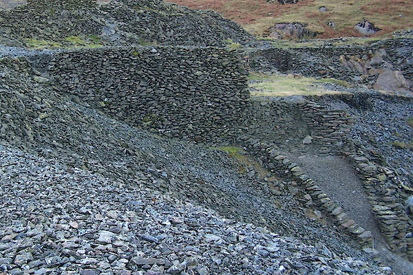 BTU47.jpg (taken 10.11.2010) |
||
|
|
||
| evidence:- | old map:- OS County Series (Cmd 80) placename:- Greenburn Copper Mine |
|
| source data:- | Maps, County Series maps of Great Britain, scales 6 and 25
inches to 1 mile, published by the Ordnance Survey, Southampton,
Hampshire, from about 1863 to 1948. OS County Series (Lan 1) "Greenburn Copper Mine &Works" |
|
|
|
||
| evidence:- | old text:- Postlethwaite 1877 (3rd edn 1913) placename:- Greenburn Mine item:- copper ore; Long Crag Vein; Pave York Vein; Gossan Vein; Sump Vein; Low Gill Vein |
|
| source data:- | Book, Mines and Mining in the English Lake District, by John Postlethwaite, Keswick,
published by W H Moss and Sons, Whitehaven, Cumberland now Cumbria, 1877; published
1877-1913. goto source goto sourcepage 119:- "GREENBURN MINE" "Is situated on the southern side of Greenburn Beck, about 2½ miles north of Coniston. There are five veins in this mine, namely, the Long Crag, Pave York, Gossan, Sump, and Low Gill veins. The mine was opened about 65 years ago, and since that time it has been worked extensively by Messrs. John Crossfield &Co., and other proprietors. Two shafts were sunk on the Sump vein, about 30 fathoms apart, one to a depth of 35, and the other 120 fathoms from the surface. The western shaft was sunk on a run of ore from 20 to 30 fathoms in length, and about 40 fathoms in depth, and which dipped rapidly to the west. The engine shaft was sunk in a similar run of ore to a depth of about 50 fathoms, but below that point the orey ground was chiefly on the eastern side of the shaft, and few of the remaining levels were extended more than a few fathoms westward." "About £25,000 worth of copper pyrites has been obtained from the Sump vein, and a considerable quantity of oxide of copper from the Pave York vein; the latter was obtained by precipitation, the precipitate yielding from 50 to 60 per cent. of copper." |
|
|
|
||
| evidence:- | old map:- Postlethwaite 1877 (3rd edn 1913) placename:- Greenburn Mine |
|
| source data:- | Map, uncoloured engraving, Map of the Lake District Mining Field, Westmorland, Cumberland,
Lancashire, scale about 5 miles to 1 inch, by John Postlethwaite, published by W H
Moss and Sons, 13 Lowther Street, Whitehaven, Cumberland, 1877 edn 1913.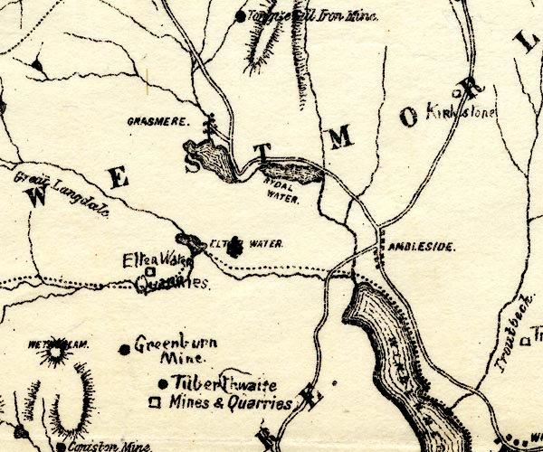 PST2NY30.jpg "Greenburn Mine" mine symbol item:- JandMN : 162.2 Image © see bottom of page |
|
|
|
||
| evidence:- | mine plan:- Postlethwaite 1877 placename:- Greenburn Mine |
|
| source data:- | Print, drawing, mine section, Section of Greenburn Mine, Coniston, Cumberland, scale
about 1 to 2900, published by W H Moss and Sons, 13 Lowther Street, Whitehaven, Cumberland,
1877 edn 1913.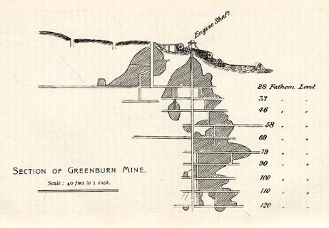 click to enlarge click to enlargePST329.jpg On p.120 of Mines and Mining in the English Lake District, by John Postlethwaite. printed, lower left "SECTION OF GREENBURN MINE. / Scale: 40 fms to 1 inch." item:- JandMN : 162.31 Image © see bottom of page |
|
|
|
||
| evidence:- | old text:- Postlethwaite 1877 (3rd edn 1913) placename:- Greenburn Mine item:- copper ore; Long Crag Vein; Pave York Vein; Gossan Vein; Sump Vein; Low Gill Vein |
|
| source data:- | Book, Mines and Mining in the English Lake District, by John Postlethwaite, Keswick,
published by W H Moss and Sons, Whitehaven, Cumberland now Cumbria, 1877; published
1877-1913. goto source page 119:- "GREENBURN MINE" "Is situated on the southern side of Greenburn Beck, about 2½ miles north of Coniston. There are five veins in this mine, namely, the Long Crag, Pave York, Gossan, Sump, and Low Gill veins. The mine was opened about 65 years ago, and since that time it has been worked extensively by Messrs. John Crossfield &Co., and other proprietors. Two shafts were sunk on the Sump vein, about 30 fathoms apart, one to a depth of 35, and the other 120 fathoms from the surface. The western shaft was sunk on a run of ore from 20 to 30 fathoms in length, and about 40 fathoms in depth, and which dipped rapidly to the west. The engine shaft was sunk in a similar run of ore to a depth of about 50 fathoms, but below that point the orey ground was chiefly on the eastern side of the shaft, and few of the remaining levels were extended more than a few fathoms westward." "About £25,000 worth of copper pyrites has been obtained from the Sump vein, and a considerable quantity of oxide of copper from the Pave York vein; the latter was obtained by precipitation, the precipitate yielding from 50 to 60 per cent. of copper." |
|
|
|
||
| evidence:- | old map:- Postlethwaite 1877 (3rd edn 1913) placename:- Greenburn Mine |
|
| source data:- | Map, uncoloured engraving, Map of the Lake District Mining Field, Westmorland, Cumberland,
Lancashire, scale about 5 miles to 1 inch, by John Postlethwaite, published by W H
Moss and Sons, 13 Lowther Street, Whitehaven, Cumberland, 1877 edn 1913. PST2NY30.jpg "Greenburn Mine" mine symbol item:- JandMN : 162.2 Image © see bottom of page |
|
|
|
||
| evidence:- | mine plan:- Postlethwaite 1877 placename:- Greenburn Mine |
|
| source data:- | Print, drawing, mine section, Section of Greenburn Mine, Coniston, Cumberland, scale
about 1 to 2900, published by W H Moss and Sons, 13 Lowther Street, Whitehaven, Cumberland,
1877 edn 1913. click to enlarge PST329.jpg On p.120 of Mines and Mining in the English Lake District, by John Postlethwaite. printed, lower left "SECTION OF GREENBURN MINE. / Scale: 40 fms to 1 inch." item:- JandMN : 162.31 Image © see bottom of page |
|
|
|
||
| evidence:- | mine drawing:- KDMRS 1979-82 placename:- Greenburn Mine |
|
| source data:- | Geological Outing of the Kendal and District Mine Research Society to Greenburn Mine,
Coniston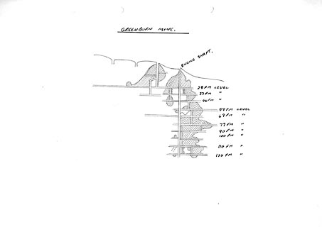 click to enlarge click to enlargeKMR25.jpg "GREENBURN MINE" item:- private collection : 82 Image © see bottom of page |
|
|
|
||
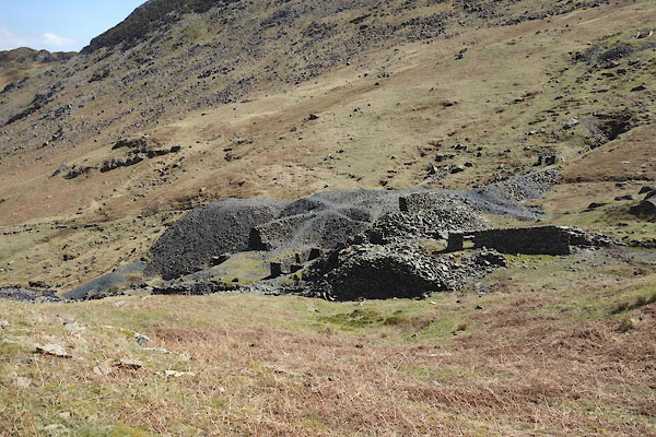
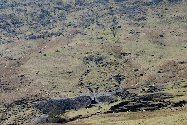 CCY04.jpg .. and the incline from Pave York Lead Mine. (taken 22.4.2015) 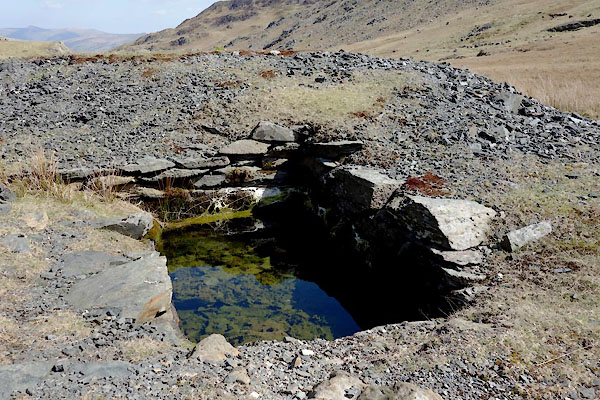 CCY03.jpg Shaft, (taken 22.4.2015) 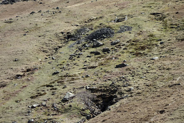 CCY05.jpg Level, Shaft, (taken 22.4.2015) 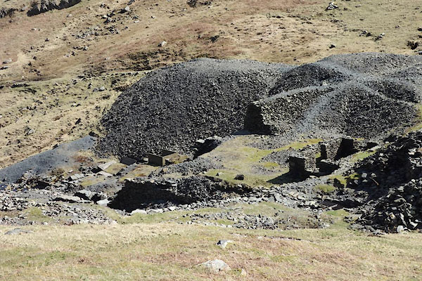 CCY07.jpg (taken 22.4.2015) 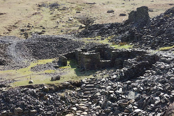 CCY08.jpg (taken 22.4.2015) 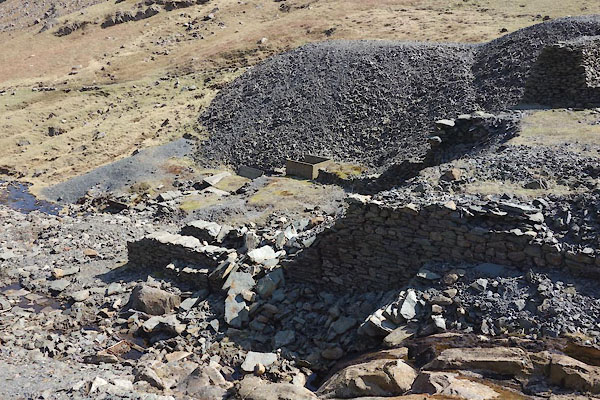 CCY09.jpg (taken 22.4.2015) 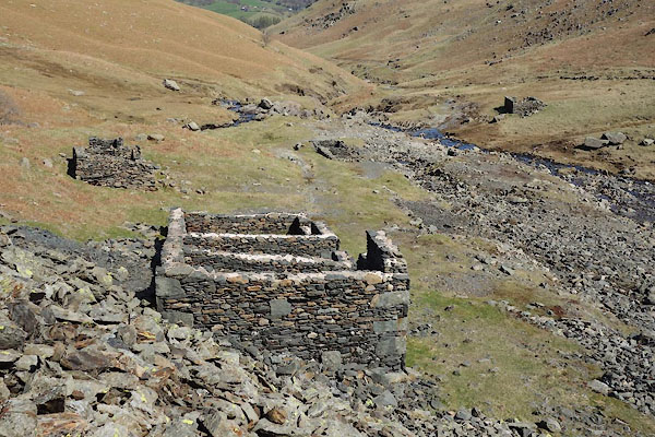 CCY10.jpg Office and smithy; across the beck is the powder store. (taken 22.4.2015) 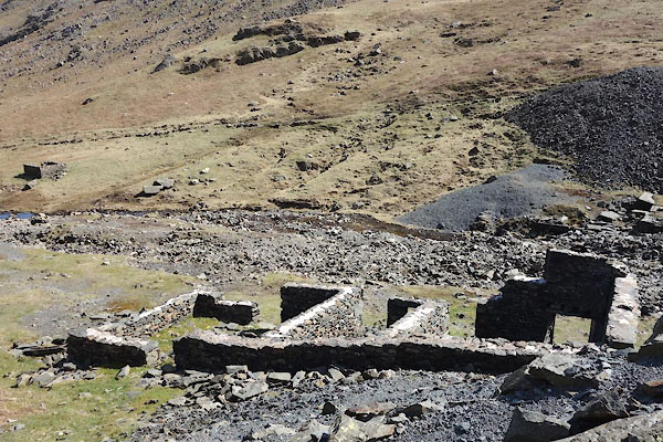 CCY11.jpg Office and smithy (taken 22.4.2015) 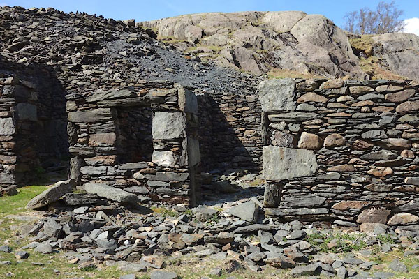 CCY12.jpg Office and smithy (taken 22.4.2015) 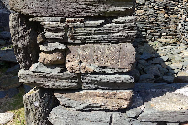 CCY13.jpg Inscription:- "J W C / 1876" (taken 22.4.2015) 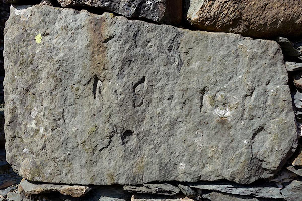 CCY14.jpg Inscription:- "[ ] 18[ ]" (taken 22.4.2015) 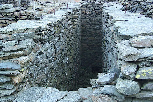 BTU50.jpg (taken 10.11.2010) 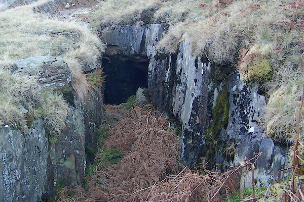 BTU48.jpg (taken 10.11.2010) 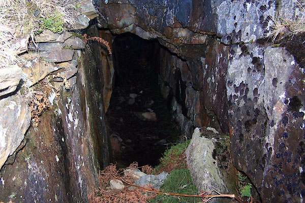 BTU49.jpg (taken 10.11.2010) 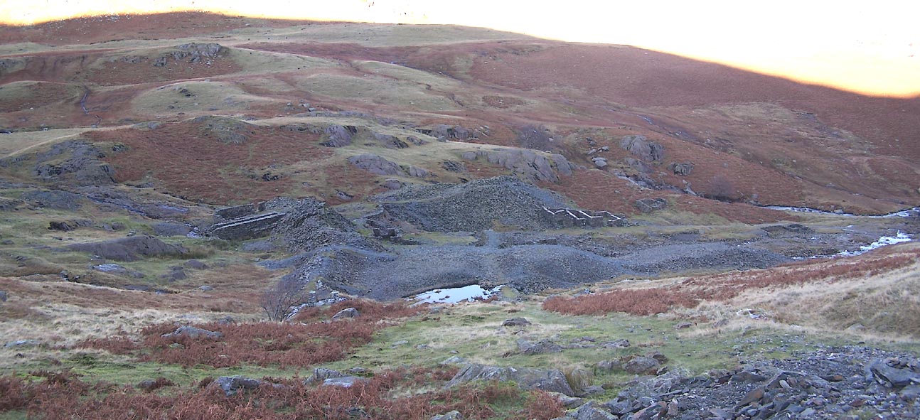 Click to enlarge BTU46.jpg (taken 10.11.2010) 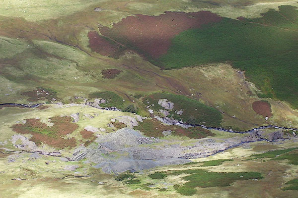 BOD11.jpg (taken 3.9.2007) |
||
|
|
||
| :- |
South bank of Greenburn Beck. Probably started 1840s; last worked about 1917. |
|
| Low Gill Lode, Sump Lode, Gossan Lode, Pave York Lode, and Long Crag Lode, accessed
by several workings. |
||
| Adams, John: 1988: Mines of the Lake District Fells: Dalesman Books (Lancaster, Lancashire)::
ISBN 0 85206 931 6 |
||
|
|
||
| :- |
Some of the workings date to about 1650. Major works date from about 1873. It is possible
to trace shafts and levels, water wheel pits, dressing floors, office and bothy, powder
store, etc. |
|
| Tyler, Ian: 2006: Lakes and Cumbria Mines Guide |
||
|
|
||
Lakes Guides menu.