 Old Cumbria Gazetteer
 |
 |
|
| Elleray, Windermere | ||
| Elleray | ||
| Elleray Park | ||
| Elleray Prep School | ||
| locality:- | Windermere | |
| civil parish:- | Windermere (formerly Westmorland) | |
| county:- | Cumbria | |
| locality type:- | buildings | |
| locality type:- | school | |
| coordinates:- | SD41129894 | |
| 1Km square:- | SD4198 | |
| 10Km square:- | SD49 | |
|
|
||
| evidence:- | old map:- OS County Series (Wmd 32 8) placename:- Elleray |
|
| source data:- | Maps, County Series maps of Great Britain, scales 6 and 25
inches to 1 mile, published by the Ordnance Survey, Southampton,
Hampshire, from about 1863 to 1948. |
|
|
|
||
| evidence:- | old map:- Jefferys 1770 (Wmd) placename:- Elray |
|
| source data:- | Map, 4 sheets, The County of Westmoreland, scale 1 inch to 1
mile, surveyed 1768, and engraved and published by Thomas
Jefferys, London, 1770.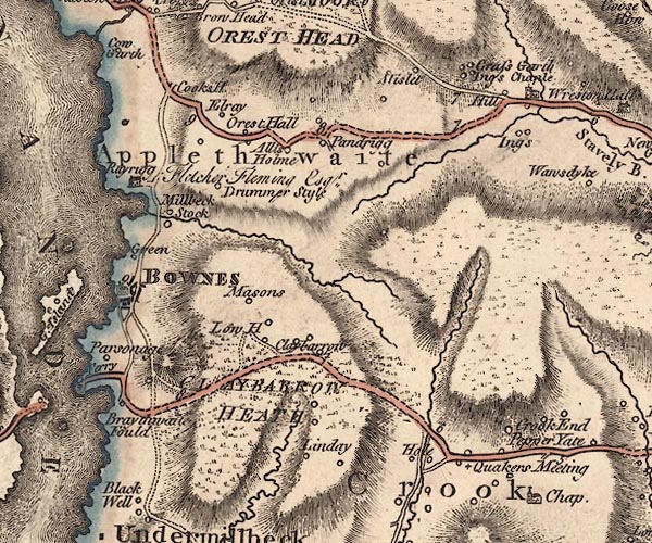 J5SD49NW.jpg "Elray" circle, labelled in italic lowercase text; settlement, farm, house, or hamlet? item:- National Library of Scotland : EME.s.47 Image © National Library of Scotland |
|
|
|
||
| evidence:- | old map:- Cary 1789 (edn 1805) placename:- Elray |
|
| source data:- | Map, uncoloured engraving, Westmoreland, scale about 2.5 miles
to 1 inch, by John Cary, London, 1789; edition 1805.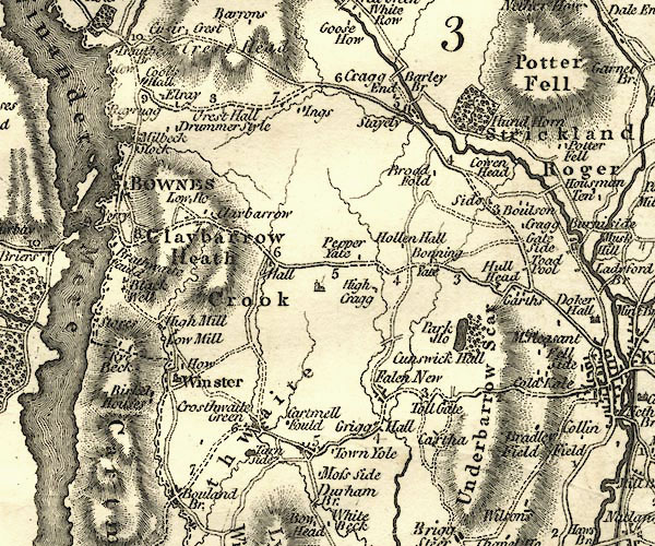 CY24SD49.jpg "Elray" block/s, labelled in italic lowercase; house, or hamlet item:- JandMN : 129 Image © see bottom of page |
|
|
|
||
| evidence:- | old map:- Otley 1818 placename:- Elleray |
|
| source data:- | Map, uncoloured engraving, The District of the Lakes,
Cumberland, Westmorland, and Lancashire, scale about 4 miles to
1 inch, by Jonathan Otley, 1818, engraved by J and G Menzies,
Edinburgh, Scotland, published by Jonathan Otley, Keswick,
Cumberland, et al, 1833.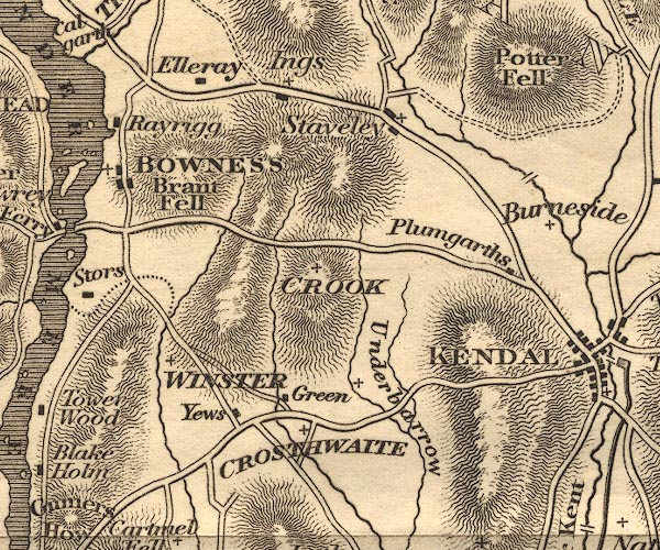 OT02SD49.jpg item:- JandMN : 48.1 Image © see bottom of page |
|
|
|
||
| evidence:- | descriptive text:- Otley 1823 (5th edn 1834) |
|
| source data:- | Guide book, A Concise Description of the English Lakes, the
mountains in their vicinity, and the roads by which they may be
visited, with remarks on the mineralogy and geology of the
district, by Jonathan Otley, published by the author, Keswick,
Cumberland now Cumbria, by J Richardson, London, and by Arthur
Foster, Kirkby Lonsdale, Cumbria, 1823; published 1823-49,
latterly as the Descriptive Guide to the English Lakes. goto source goto sourcePage 4:- "... Elleray, the occasional abode of Professor Wilson, ... elevated situation. ..." |
|
|
|
||
| evidence:- | descriptive text:- Ford 1839 (3rd edn 1843) placename:- Elleray |
|
| source data:- | Guide book, A Description of Scenery in the Lake District, by
Rev William Ford, published by Charles Thurnam, Carlisle, by W
Edwards, 12 Ave Maria Lane, Charles Tilt, Fleet Street, William
Smith, 113 Fleet Street, London, by Currie and Bowman,
Newcastle, by Bancks and Co, Manchester, by Oliver and Boyd,
Edinburgh, and by Sinclair, Dumfries, 1839. goto source Page 23:- "... Elleray, the seat of Professor Wilson, on a most desirable and commanding situation; ..." |
|
|
|
||
| evidence:- | old map:- Garnett 1850s-60s H placename:- Elleray |
|
| source data:- | Map of the English Lakes, in Cumberland, Westmorland and
Lancashire, scale about 3.5 miles to 1 inch, published by John
Garnett, Windermere, Westmorland, 1850s-60s.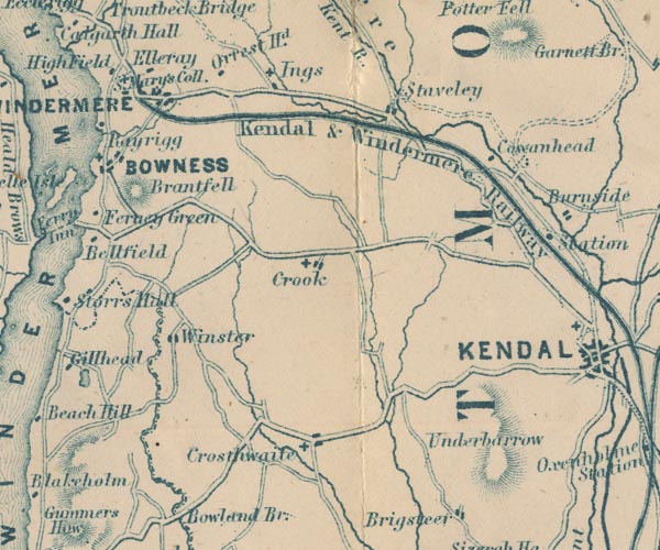 GAR2SD49.jpg "Elleray" block, building item:- JandMN : 82.1 Image © see bottom of page |
|
|
|
||
| evidence:- | old text:- Martineau 1855 |
|
| source data:- | Guide book, A Complete Guide to the English Lakes, by Harriet
Martineau, published by John Garnett, Windermere, Westmorland,
and by Whittaker and Co, London, 1855; published 1855-76. goto source Page 6:- "The hill to the right is part of the Elleray property, so well known as the lake-home of Christopher North, and now so much improved by its present proprietor, Mr. Eastted. If the traveller should have the good fortune to obtain a ticket of leave to enter the" goto sourcePage 7:- "grounds,[1] his first object should be to walk up that hill at Elleray, by Mr. Eastted's new drive. All the way up, the views are exquisite: but that from the summit,- about 700 feet above the lake, is one of the finest the district can show. The whole length of Windermere extends below, with its enclosing hills and wooded islands; and towards the head, some of the highest peaks and ridges may be seen:- Coniston Old Man to the west; Bowfell and the Langdale Pikes to the northwest; Fairfield to the north, with Loughrigg lying, as a mere dark ridge, across the head of Windermere; while, to the north-east, Troutbeck is disclosed, with its peaks of High Street and Hill Bell. All below are woods, with houses peeping out; on a height of the opposite shore, Wray Castle; further north, the little Brathay Chapel, set down near the mouth of the valley; and between Loughrigg and the lake, at its head, the white houses of Clappersgate, with the chateau-like mansion of Croft Lodge conspicuous above the rest. ..." footnote [1] "A portion of the Elleray grounds are open to the public every Monday and Friday. Tickets of admission, bearing date, are issued on application to Mr. Garnett, at the Windermere Post-office, by paying a small donation, not less than one shilling, for a party of six persons, and, if above that number, the donation must he doubled. The proceeds are for the benefit of the school for the education of the poor, established by the Rev. J. A. Addison, and the sick and aged poor of Windermere, who may need assistance.- Parties will enter at the gate opposite the post-office, and proceed up the road to the right, which is the main road leading to the top of the hill, and return by the same route. All branch roads are strictly private." |
|
|
|
||
| evidence:- | old text:- Martineau 1855 |
|
| source data:- | Guide book, A Complete Guide to the English Lakes, by Harriet
Martineau, published by John Garnett, Windermere, Westmorland,
and by Whittaker and Co, London, 1855; published 1855-76. goto source Page 14:- "... He [Professor Wilson] was known, and with reverence and affection, beside the trout-stream and the mountain tarn, and, amidst the damp gloom of Elleray, where he could not bring himself to let a tree or a sprig be lopped that his wife had loved. ..." |
|
|
|
||
| evidence:- | old map:- Prior 1874 map 1 placename:- Elleray |
|
| source data:- | Map, uncoloured engraving or lithograph? Winander Mere, scale
about 2.5 miles to 1 inch, published by John Garnett,
Windermere, Westmorland, 1874. click to enlarge click to enlargePI03M1.jpg "Elleray" block/s; building/s item:- private collection : 133.1 Image © see bottom of page |
|
|
|
||
| evidence:- | old photograph:- Bell 1880s-1940s |
|
| source data:- | Photograph, black and white, Elleray, Windermere, Westmorland, by Herbert Bell, photographer,
Ambleside, Westmorland, 1890s.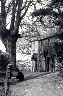 click to enlarge click to enlargeHB0814.jpg stamped at reverse:- "HERBERT BELL / Photographer / AMBLESIDE" item:- Armitt Library : ALPS477 Image © see bottom of page |
|
|
|
||
| evidence:- | old photograph:- Bell 1880s-1940s |
|
| source data:- | Photograph, sepia, Elleray, Windermere, Westmorland, by Herbert Bell, photographer,
Ambleside, Westmorland, 1890s.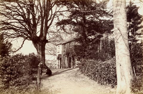 click to enlarge click to enlargeHB0889.jpg item:- Armitt Library : ALPS560 Image © see bottom of page |
|
|
|
||
| notes:- |
Built by Christopher North, about 1807. |
|
| Hyde, Matthew & Whittaker, Esme &Corbet, Val (photographer): 2014: Arts and Craft
Houses in the Lake District: Lincoln, Francis (London):: ISBN 978 0 7112 3408 6 |
||
|
|
||
Lakes Guides menu.