 Old Cumbria Gazetteer
 |
 |
|
| Castle Head, Keswick | ||
| Castle Head | ||
| civil parish:- | Keswick (formerly Cumberland) | |
| county:- | Cumbria | |
| locality type:- | hill | |
| coordinates:- | NY26972268 (etc) | |
| 1Km square:- | NY2622 | |
| 10Km square:- | NY22 | |
| altitude:- | 531 feet | |
| altitude:- | 162m | |
|
|
||
| evidence:- | old map:- OS County Series (Cmd 64 6) placename:- Castle Head |
|
| source data:- | Maps, County Series maps of Great Britain, scales 6 and 25
inches to 1 mile, published by the Ordnance Survey, Southampton,
Hampshire, from about 1863 to 1948. |
|
|
|
||
| evidence:- | old map:- Donald 1774 (Cmd) placename:- Castle Head |
|
| source data:- | Map, hand coloured engraving, 3x2 sheets, The County of Cumberland, scale about 1
inch to 1 mile, by Thomas Donald, engraved and published by Joseph Hodskinson, 29
Arundel Street, Strand, London, 1774.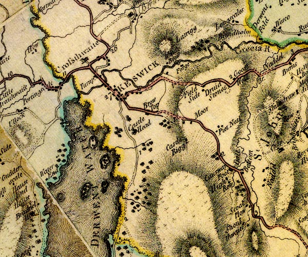 D4NY22SE.jpg "Castle Head" no symbol item:- Carlisle Library : Map 2 Image © Carlisle Library |
|
|
|
||
| evidence:- | descriptive text:- West 1778 (11th edn 1821) placename:- Castle Hill |
|
| source data:- | Guide book, A Guide to the Lakes, by Thomas West, published by
William Pennington, Kendal, Cumbria once Westmorland, and in
London, 1778 to 1821. goto source goto sourceAddendum; Mr Gray's Journal, 1769 Page 203:- "Oct. 3. [at Keswick] A heavenly day; rose at seven, and walked out under the conduct of my landlord to Borrowdale; ... Left Cockshut (which we formerly mounted) and Castle-hill, a loftier and more rugged hill behind me, ..." goto sourcePage 208:- "[from Fawe Park] ... in front rises Wallow-crag and Castle-hill, the town, the road to Penrith, Skiddaw, and Saddleback. ..." |
|
|
|
||
| evidence:- | old map:- Crosthwaite 1783-94 (Der) placename:- Castle Hill |
|
| source data:- | Map, uncoloured engraving, An Accurate Map of the Matchless Lake
of Derwent, ie Derwent Water, scale about 3 inches to 1 mile, by
Peter Crosthwaite, Keswick, Cumberland, 1783, version published
1800.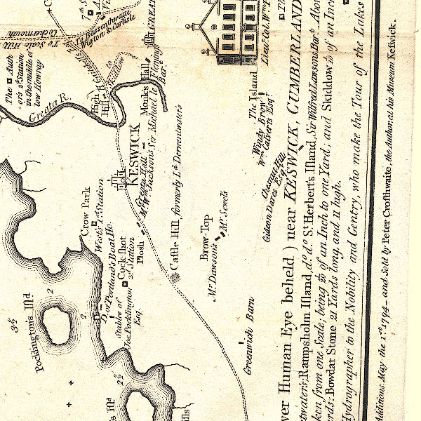 CT2NY22Q.jpg "Castle Hill / formerly Ld. Derwentwater's" item:- Armitt Library : 1959.191.3 Image © see bottom of page |
|
|
|
||
| evidence:- | perhaps old map:- West 1784 map placename:- Castlehill |
|
| source data:- | Map, hand coloured engraving, A Map of the Lakes in Cumberland,
Westmorland and Lancashire, scale about 3.5 miles to 1 inch,
engraved by Paas, 53 Holborn, London, about 1784. Ws02NY22.jpg item:- Armitt Library : A1221.1 Image © see bottom of page |
|
|
|
||
| evidence:- | old text:- Gilpin 1786 placename:- Castellet |
|
| source data:- | Book, Observations, Relative Chiefly to Picturesque Beauty, Made
in the Year 1772, on Several Parts of England, Particularly the
Mountains, and Lakes of Cumberland Westmoreland, by Rev William
Gilpin, 1772-74; published 1786-1808. goto source vol.1 p.187 "" "Detached from this continent of precipice, if I may so speak, stands a rocky hill, known by the name of Castellet. Under the beetling brow of this natural ruin we passed; and as we viewed it upwards from it's base, it seemed a fabric of such grandeur, that alone it was sufficient to give dignity to any scene. We were desired to take particular notice of it for a reason, which shall afterwards be mentioned." "..." goto sourcevol.1 p.190 "As we approached the head of the lake, we were desired to turn round, and take a view of Castellet, that rocky hill, which had appeared so enormous, as we stood under it. It had now shrunk into nothing in the midst of that scene of greatness, which surrounded it. I mention the circumstance, as in these wild countries, comparison is the only scale used in the mensuration of mountains: at least it was the only scale, to which we were ever referred. In countries graced by a single mountain, the inhabitants may be very accurate in their investigation of it's height. ..." |
|
|
|
||
| evidence:- | probably old print:- Green 1804 (plate 18) placename:- Castle Crag |
|
| source data:- | Print, uncoloured aquatint, Skiddaw, taken from Castle Crag, near Keswick, Cumberland,
by William Green, Ambleside, Westmorland, 1804.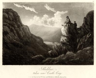 click to enlarge click to enlargeGN1618.jpg Plate 18 from a series. printed at bottom:- "Skiddaw, / taken from Castle Crag. / Drawn and Engraved by Wm. Green, and Published at Ambleside, June 24, 1804." printed at top right:- "18" item:- Armitt Library : 2014.164 Image © see bottom of page |
|
|
|
||
| evidence:- | descriptive text:- Otley 1823 (5th edn 1834) placename:- Castlehead |
|
| source data:- | Guide book, A Concise Description of the English Lakes, the
mountains in their vicinity, and the roads by which they may be
visited, with remarks on the mineralogy and geology of the
district, by Jonathan Otley, published by the author, Keswick,
Cumberland now Cumbria, by J Richardson, London, and by Arthur
Foster, Kirkby Lonsdale, Cumbria, 1823; published 1823-49,
latterly as the Descriptive Guide to the English Lakes. goto source Page 118:- "... Castlehead, which is a wooded rock rising, in the centre of the Derwentwater estate, to the height of 280 feet above the lake. ..." |
|
|
|
||
| evidence:- | old print:- Westall 1830s placename:- Castlet |
|
| source data:- | Print, aquatint panorama, Keswick Lake, from the West Side, near Water End, Cumberland,
drawn and engraved by William Westall, published by Ackermann and Co, 96 Strand, London,
1833.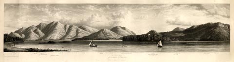 click to enlarge click to enlargeWTL315.jpg "Skiddaw Dod Mill beck Summit of Skiddaw, 3022ft. Crosthwaite Church Lingholm's Islands Applethwaite Ormathwaite Istmus Latrigg 1160ft. Town of Keswick Saddleback or Blencathra 2787ft. Vicar or Derwent Island Genl. Peachey's house. Castlet. Friar's Crag White Pike Lord's island Walla Crag / Drawn & Engraved by W. Westall A.R.A. / Keswick Lake, / from the West side, near Water End. / Published by Ackermann and Co, 96 Strand. 1833." item:- Armitt Library : A6658.15 Image © see bottom of page |
|
|
|
||
| evidence:- | descriptive text:- Ford 1839 (3rd edn 1843) placename:- Castlehead |
|
| source data:- | Guide book, A Description of Scenery in the Lake District, by
Rev William Ford, published by Charles Thurnam, Carlisle, by W
Edwards, 12 Ave Maria Lane, Charles Tilt, Fleet Street, William
Smith, 113 Fleet Street, London, by Currie and Bowman,
Newcastle, by Bancks and Co, Manchester, by Oliver and Boyd,
Edinburgh, and by Sinclair, Dumfries, 1839. goto source Page 59:- "..." "CASTLEHEAD AND WALLOW CRAG." "There is a beautiful and entertaining walk to the summit of these, which is gained by proceeding" goto sourcePage 59:- "a short distance on the Borrowdale road, and then turning up the woods to the left. At the commencement is a superb view of Keswick, the church, and Bassenthwaite. On the top are benches, where you may rest, and look over the soft bosom of the lake full into the gorge of Borrowdale, which is the grandest aspect. To the north is Bassenthwaite Water and the stately Skiddaw." |
|
|
|
||
| evidence:- | old map:- Garnett 1850s-60s H placename:- Castlehead |
|
| source data:- | Map of the English Lakes, in Cumberland, Westmorland and
Lancashire, scale about 3.5 miles to 1 inch, published by John
Garnett, Windermere, Westmorland, 1850s-60s.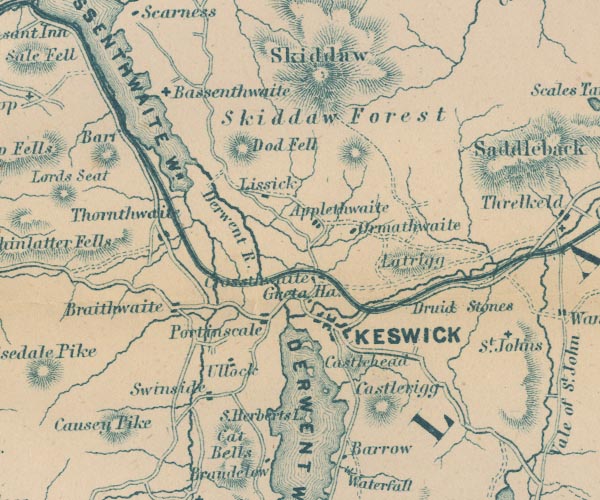 GAR2NY22.jpg "Castlehead" hill hachuring item:- JandMN : 82.1 Image © see bottom of page |
|
|
|
||
| evidence:- | old text:- Martineau 1855 placename:- Castlehead |
|
| source data:- | Guide book, A Complete Guide to the English Lakes, by Harriet
Martineau, published by John Garnett, Windermere, Westmorland,
and by Whittaker and Co, London, 1855; published 1855-76. goto source Page 74:- "... The uppermost thought at all points about the foot of the lake [Derwent Water] is of the Derwentwater family. They had once a castle on the hill called Castlehead, where they built upon the site of a Druidical circle. This hill should be visited for the view. ..." |
|
|
|
||
| evidence:- | old print:- Heaton Cooper 1905 (edn 1908) placename:- Castle Head item:- tree; Scots pine; Pinus sylvestris |
|
| source data:- | Print, colour halftone, Derwentwater, from Castle Head, a bright morning, Keswick,
Cumberland, from a watercolour painting by Alfred Heaton Cooper, published by Adam
and Charles Black, London, 2nd edn 1908.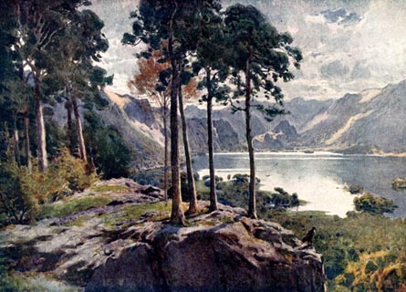 click to enlarge click to enlargeHC0147.jpg Opposite p.138 of The English Lakes, painted by Alfred Heaton Cooper, described by William T Palmer. printed at tissue opposite the print:- "DERWENTWATER, FROM CASTLE HEAD / A bright morning" printed at signed lower right:- "[A HEATON COOPER]" item:- JandMN : 468.47 Image © see bottom of page |
|
|
|
||
| evidence:- | old print:- Reynolds 1915 placename:- Castle Head |
|
| source data:- | Print, colour halftone, Derwent Water from Castle Head, Keswick, Cumberland, from
a painting by Alfred Heaton Cooper, published by Adam and Charles Black, London, 1915.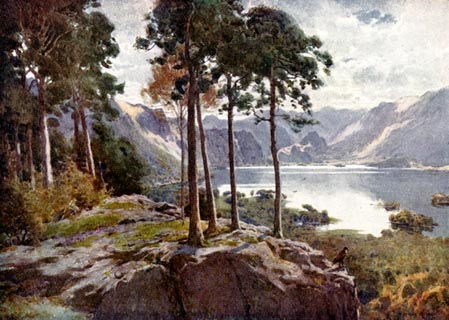 click to enlarge click to enlargeREY612.jpg "A HEATON COOPER" "DERWENT WATER FROM CASTLE HEAD." item:- JandMN : 1071.12 Image © see bottom of page |
|
|
|
||
| evidence:- | old postcard:- placename:- Castle Head |
|
| source data:- | Postcard, colour printed photograph, Derwent Water from Castle Head, Keswick, Cumberland,
published mid 20th century?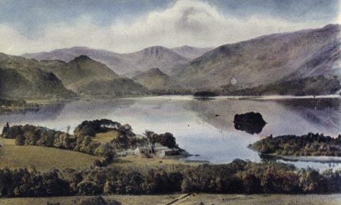 click to enlarge click to enlargePH0092.jpg printed at bottom:- "DERWENTWATER FROM CASTLE HEAD, KESWICK" item:- JandMN : 960 Image © see bottom of page |
|
|
|
||
| evidence:- | outline view:- Baddeley 1930s |
|
| source data:- | Print, lithograph, Panorama from Castle Head, Keswick, engraved by John Bartholomew
and Co, Edinburgh, published by Ward, Lock and Co, Warwick House, Salisbury Square,
London, 1930s.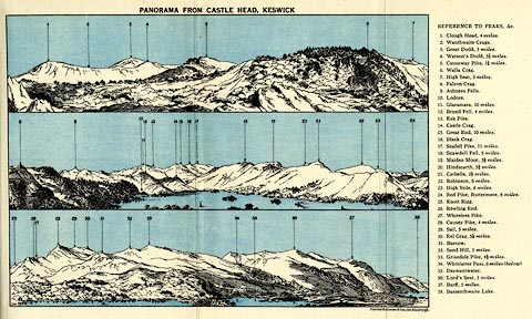 click to enlarge click to enlargeBE01E2.jpg item:- JandMN : 305.2 Image © see bottom of page |
|
|
|
||
| evidence:- | outline view:- Watson 1912 |
|
| source data:- | Outline view, black and white halftone, Mountains Seen from Castle Head, Keswick,
Cumberland, published by George Watson, after 1912.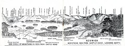 click to enlarge click to enlargeWT4Ov.jpg In a guide book, Keswick on Derwentwater. item:- Keswick Museum : 2145.4 Image © see bottom of page |
|
|
|
||
| evidence:- | outline view:- Red Guide 1892 |
|
| source data:- | Print, engraving, pair of outline views, Mountains as seen from Castlehead, Keswick,
and Mountains as seen from the West Side of Grange in Borrowdale looking west, published
by Ward, Lock and Co, Warwick House, Salisbury Square, London, etc, 1892.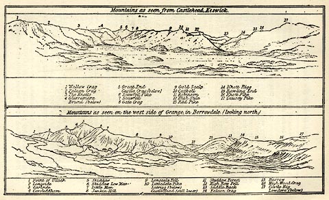 click to enlarge click to enlargeRG0103.jpg "1 Wallow Crag 2 Falcon Crag 3 The Knotts 4 Glaramara / Brund (below) 5 Great End / Castle Crag (below) 6 Scawfell Pike 7 Scawfell 8 Gate Crag 9 Gold Scalp 10 Catbell 11 Robinson 12 High Stile 13 Red Pike 14 Knott Rigg 15 Rawling End 16 Knott Pike 17 Causey Pike" On p.150 in the Red Guide guide book, Guide to the English Lakes. item:- JandMN : 102.4 Image © see bottom of page |
|
|
|
||
| evidence:- | outline view:- Black 1856 (23rd edn 1900) placename:- Castlehead |
|
| source data:- | Print, lithograph, Outline Views, Skiddaw and Derwent Water - Mountains as seen at
Lodore Hotel, and Mountains as seen at the Third Gate on Ascending Latrigg on the
Way to Skiddaw, by J Flintoft, Keswick, Cumberland, engraved by R Mason, Edinburgh,
Lothian, about 1900.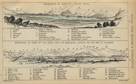 click to enlarge click to enlargeBC08E4.jpg "... 12 Castlehead ... 4 Castlehead ..." item:- JandMN : 37.14 Image © see bottom of page |
|
|
|
||
| evidence:- | outline view:- Black 1841 (3rd edn 1846) placename:- Castlehead |
|
| source data:- | Print, engraving, outline view, Mountains as seen at Lowdore Inn, and Mountains as
seen at the Third Gate on Ascending Latrigg on the Way to Skiddaw, by J Flintoft,
Keswick, Cumberland, engraved by R Mason, Edinburgh, Lothian, about 1846.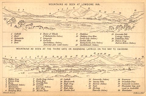 click to enlarge click to enlargeBC02E4.jpg "... 12 Castlehead ... 4 Castlehead ..." item:- JandMN : 32.7 Image © see bottom of page |
|
|
|
||
| evidence:- | outline view:- Tattersall 1836 (version 1869) placename:- Castle Hill |
|
| source data:- | Print, hand coloured, Derwentwater and Bassenthwaite Lakes, from the road to Watendlath,
Cumberland, drawn by George Tattersall, 1836, engraved by W F Topham, published by
T J Allman, 463 Oxford Street, London, 1869.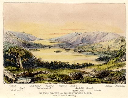 click to enlarge click to enlargeTAT212.jpg Included in The Lakes of England, by W F Topham. printed at bottom:- "DERWENTWATER and BASSENTHWAITE LAKES, / from the road to Watendlath." printed at bottom:- "Swinside. / Lord's Seat. / Barff. / St. Herbert's I. / Bassenthwaite L. / Ramps I. / Vicar's I. / Lord's I. / Skiddaw Dodd. / Castle Hill. / Keswick. / Skiddaw. / Latrigg. / Falcon Crag." item:- Armitt Library : A1067.12 Image © see bottom of page |
|
|
|
||
| evidence:- | outline view:- Tattersall 1836 placename:- Castle Hill |
|
| source data:- | Print, engraving, Derwentwater and Bassenthwaite Lakes, from the road to Watenflath,
Cumberland, drawn by George Tattersall, engraved by W F Topham, published by Sherwood
and Co, Paternoster Row, London, about 1836.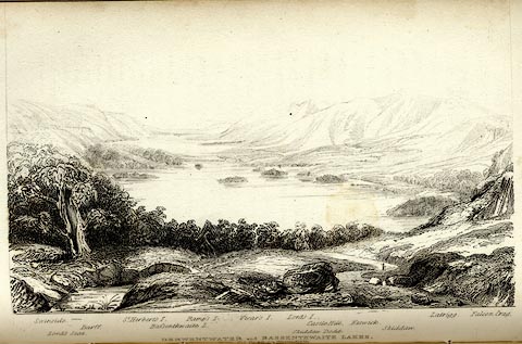 click to enlarge click to enlargeTAT130.jpg The print is captioned with mountain names and acts as an outline view. Tipped in opposite p.77 of The Lakes of England, by George Tattersall. printed at bottom:- "DERWENTWATER and BASSENTHWAITE LAKES, / from the road to Watendlath." printed at bottom left to right:- "Swinside. / Lord's Seat. / Barff. / St. Herbert's I. / Bassenthwaite L. / Ramp's I. / Vicar's I. / Lord's I. / Skiddaw Dodd. / Castle Hill. / Keswick. / Skiddaw. / Latrigg. / Falcon Crag." item:- Armitt Library : A1204.31 Image © see bottom of page |
|
|
|
||
| evidence:- | possibly outline view:- placename:- Castle Hill |
|
| source data:- | Print, uncoloured engraving, Derwentwater and Bassenthwaite Lakes from the Road to
Watendlath, Cumberland, published by Sherwood and Co, London, 1836?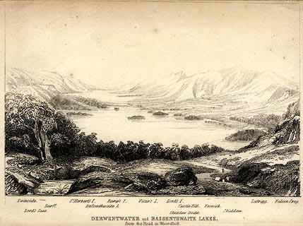 click to enlarge click to enlargePR0370.jpg The view is from just above Ashness Bridge. Objects in the view are identified by a caption at the bottom (unfortunately the print is pale, so some objects are unclear, and the caption seems to be a little misaligned) - Swinside, Lord's Seat, Barff, St. Herbert's I., Bassenthwaite L., Ramp's I., Vicar's I., Lord's I., Skiddaw Dodd, Castle Hill, Keswick, Skiddaw, Latrigg, Falcon Crag. printed at bottom:- "DERWENTWATER and BASSENTHWAITE LAKES. / from the Road to Watendlath." item:- Dove Cottage : 2008.107.370 Image © see bottom of page |
|
|
|
||
Lakes Guides menu.