 Old Cumbria Gazetteer
 |
 |
|
| Castle Crag, Borrowdale | ||
| Castle Crag | ||
| civil parish:- | Borrowdale (formerly Cumberland) | |
| county:- | Cumbria | |
| locality type:- | rocks | |
| coordinates:- | NY24931592 | |
| 1Km square:- | NY2415 | |
| 10Km square:- | NY21 | |
|
|
||
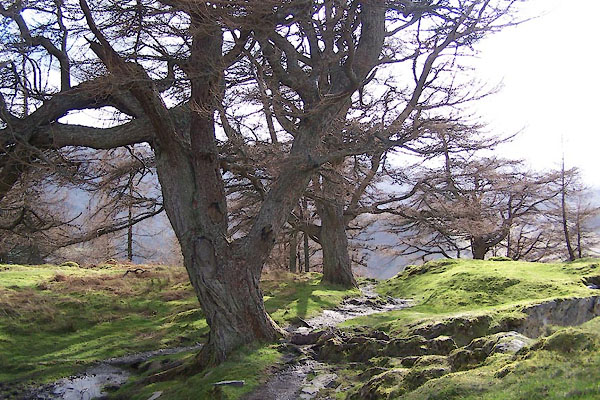
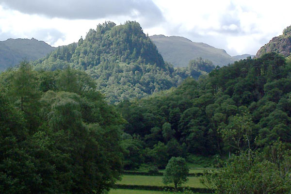 BUW36.jpg (taken 29.6.2011) 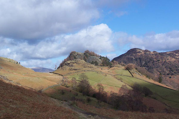 BWB07.jpg (taken 6.3.2012) |
||
|
|
||
| evidence:- | old map:- OS County Series (Cmd 70 5) placename:- Castle Crag |
|
| source data:- | Maps, County Series maps of Great Britain, scales 6 and 25
inches to 1 mile, published by the Ordnance Survey, Southampton,
Hampshire, from about 1863 to 1948. |
|
|
|
||
| evidence:- | old map:- Donald 1774 (Cmd) placename:- Castle Hill |
|
| source data:- | Map, hand coloured engraving, 3x2 sheets, The County of Cumberland, scale about 1
inch to 1 mile, by Thomas Donald, engraved and published by Joseph Hodskinson, 29
Arundel Street, Strand, London, 1774.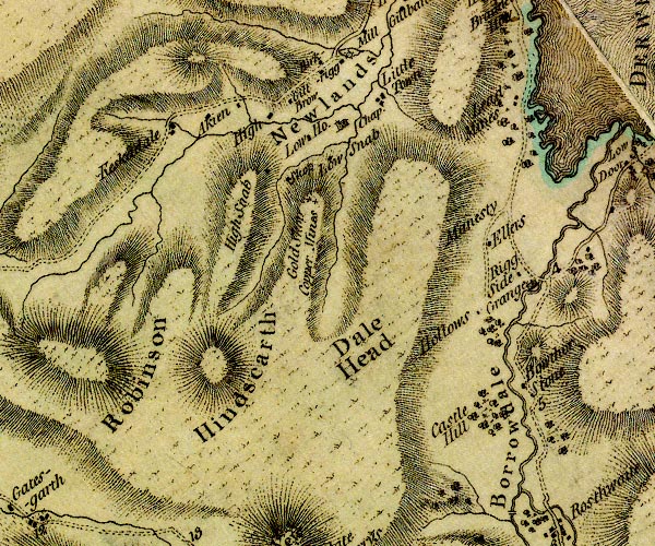 D4NY21NW.jpg "Castle Hill" marked by woodland item:- Carlisle Library : Map 2 Image © Carlisle Library |
|
|
|
||
| evidence:- | descriptive text:- West 1778 (11th edn 1821) placename:- Castle Crag |
|
| source data:- | Guide book, A Guide to the Lakes, by Thomas West, published by
William Pennington, Kendal, Cumbria once Westmorland, and in
London, 1778 to 1821. goto source goto sourcePage 93:- "... Castle-crag may be seen, in the centre of the amphitheatre, threatening to block up the pass it once defended. ..." goto sourcePage 94:- "On the summit of Castle-crag are the remains of a fort; ..." "..." goto sourcePage 107:- "The prospect to the south [from Latrigg] ... full into the rocky jaws of Borrowdale, ... Castle-crag, in Borrowdale, stands first of all the forest of embattled rocks, whose forked heads, reared to the sky, shine in the sun like spears of burnished steel. ..." goto sourceAddendum; Mr Gray's Journal, 1769 Page 205:- "... Beside the village [Grange] rises a round eminence of a rock covered entirely in old trees, and over that more proudly towers Castle-cragg, invested also with wood on its sides, and bearing on its naked top some traces of a fort, said to be Roman, By the side of this hill, which almost blocks up the way, the valley turns to the left, and contracts its dimensions till there is hardly any road but the rocky bed of the river. ..." |
|
|
|
||
| evidence:- | old map:- West 1784 map placename:- Castle Crag |
|
| source data:- | Map, hand coloured engraving, A Map of the Lakes in Cumberland,
Westmorland and Lancashire, scale about 3.5 miles to 1 inch,
engraved by Paas, 53 Holborn, London, about 1784. Ws02NY21.jpg item:- Armitt Library : A1221.1 Image © see bottom of page |
|
|
|
||
| evidence:- | old text:- Gents Mag placename:- Castle Crags |
|
| source data:- | Magazine, The Gentleman's Magazine or Monthly Intelligencer or
Historical Chronicle, published by Edward Cave under the
pseudonym Sylvanus Urban, and by other publishers, London,
monthly from 1731 to 1922. goto source Gentleman's Magazine 1805 p.1122 "... In the midst of this dreary chasm, an isolated spire of rock, invested on all sides with foliage of the liveliest verdure, stood like a tower. Castle Crags which the Antiquaries dignify with the honours of a Roman Fort. Of this, if it ever existed, Time has long sapped the foundations, and dispersed the ruins; but its muffled pediment has not denied a refuge to the later posterity of the Roman Eagle. ..." |
|
|
|
||
| evidence:- | old print:- Green 1815 placename:- Castle Crag |
|
| source data:- | Print, coloured aquatint, Derwent Water from Castle Crag, Borrowdale, Cumberland,
by William Green, Ambleside, Westmorland, 1815.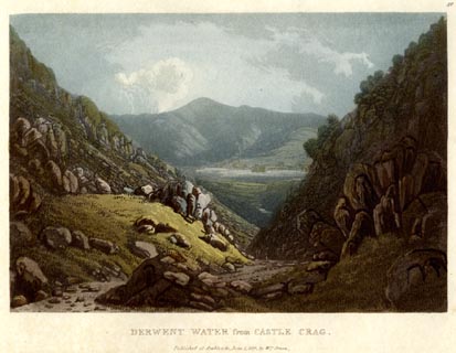 click to enlarge click to enlargeGN0537.jpg Plate 40 in Lake Scenery. printed at upper right:- "40" printed at bottom:- "DERWENT WATER from CASTLE CRAG. / Published at Ambleside, June 1, 1815, by Wm. Green." item:- Armitt Library : A6646.37 Image © see bottom of page |
|
|
|
||
| evidence:- | old print with text:- Farington 1816 placename:- Castle Crag |
|
| source data:- | Print, uncoloured engraving and descriptive text, Castle Crag and Bowder Stone, Borrowdale,
Cumberland, drawn by Joseph Farington, engraved by J Byrne, published by T Cadell
and W Davies, Strand, London, 1815.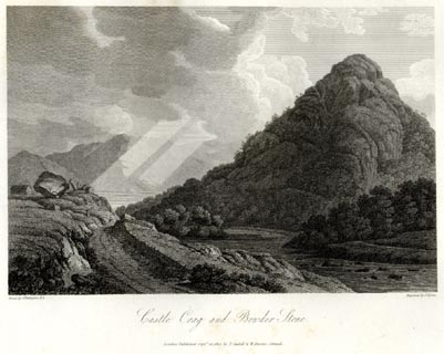 click to enlarge click to enlargeFA0416.jpg printed, bottom left, right, centre "Drawn by J. Farington R.A. / Engraved by J. Byrne. / Castle Crag and Bowder Stone. / London Published Septr. 15, 1815, by T. Cadell &W. Davies, Strand." Descriptive text:- "CASTLE CRAG AND BOWDER-STONE." "CASTLE CRAG is a detached mountain covered with wood, supposed to be of Roman origin, which obtained its name from a fortress that once frowned on its summit, and guarded the tremendous pass of Borrowdale. After it had been relinquished by the Romans, it was occupied by the Saxons; and was subsequently given, with all the lands about Borrowdale, by one of the Lords of Derwentwater, to the monks of Furness. By these religious it was for many years continued in its military capacity, to defend their valuable possessions in the valley of Borrowdale against the predatory incursions of the Scots, who in those days frequently made irruptions thus far south. The views from the top of Castle Crag are grand and extensive. On one side are the lake and vale of Keswick, with their accompaniments of rocks, islands, villages, seats, farm-houses and cottages, with the majestic Skiddaw overlooking the more rugged neighbouring mountains in the back-ground: and on the other side appears the pass of Borrowdale, where immense rocky mountains are huddled together in the most singular arrangement." "..." item:- Armitt Library : A6666.16 Image © see bottom of page |
|
|
|
||
| evidence:- | old map:- Otley 1818 placename:- Castle Crag |
|
| source data:- | Map, uncoloured engraving, The District of the Lakes,
Cumberland, Westmorland, and Lancashire, scale about 4 miles to
1 inch, by Jonathan Otley, 1818, engraved by J and G Menzies,
Edinburgh, Scotland, published by Jonathan Otley, Keswick,
Cumberland, et al, 1833. OT02NY21.jpg item:- JandMN : 48.1 Image © see bottom of page |
|
|
|
||
| evidence:- | outline view:- Otley 1823 (4th edn 1830) placename:- Castle Crag |
|
| source data:- | Print, engraving, outline view, Mountains South West of Derwentwater as seen from
Keswick, published by Jonathan Otley, Keswick, Cumberland et al, 1830.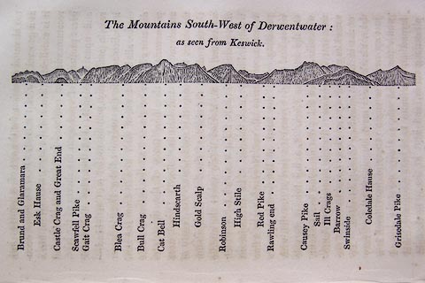 click to enlarge click to enlargeO75E06.jpg p.115 in A Concise Description of the English Lakes, by Jonathan Otley, 4th edition, 1830. "The Mountains South-West of Derwentwater: / as seen from Keswick." "Brund and Glaramara / Esk Hause / Castle Crag and Great End / Scawfell Pike / Gait Crag / Blea Crag / Bull Crag / Cat Bell / Hindscarth / Gold Scalp / Robinson / High Stile / Red Pike / Rawling end / Causey Pike / Sail / Ill Crags / Barrow / Swinside / Coledale Hause / Grisedale Pike" item:- Armitt Library : A1175.6 Image © see bottom of page |
|
|
|
||
| evidence:- | outline view:- Otley 1823 (8th edn 1849) placename:- Castle Crag |
|
| source data:- | Engraving, outline view of mountains, Derwent Water from Crow Park, drawn by T Binns,
engraved by O Jewitt, opposite p.10 of A Descriptive Guide of the English Lakes, by
Jonathan Otley, 8th edition, 1849.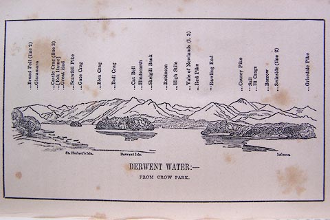 click to enlarge click to enlargeO80E06.jpg item:- Armitt Library : A1180.7 Image © see bottom of page |
|
|
|
||
| evidence:- | outline view:- Otley 1823 (5th edn 1834) |
|
| source data:- | Print, woodcut outline view, The Mountains South West of
Derwentwater, by Jonathan Otley, Keswick, Cumberland, 1830.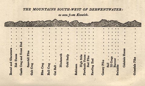 click to enlarge click to enlargeOT2E04.jpg Printed on p.21 of A Concise Description of the English Lakes, by Jonathan Otley, 5th edition, 1834. "THE MOUNTAINS SOUTH-WEST OF DERWENTWATER: as seen from Keswick" "Brund and Glaramara / Esk Hause / Castle Crag and Great End / Scawfell Pike / Gait Crag / Blea Crag / Bull Crag / Cat Bell / Hindscarth / Gold Scalp / Robinson / High Stile / Newlands Hause / Red Pike / Rawling End / Causey Pike / Sail / Ill Crags / Barrow / Swinside / Coledale Hause / Grisedale Pike" item:- JandMN : 48.5 Image © see bottom of page |
|
|
|
||
| evidence:- | descriptive text:- Otley 1823 (5th edn 1834) |
|
| source data:- | Guide book, A Concise Description of the English Lakes, the
mountains in their vicinity, and the roads by which they may be
visited, with remarks on the mineralogy and geology of the
district, by Jonathan Otley, published by the author, Keswick,
Cumberland now Cumbria, by J Richardson, London, and by Arthur
Foster, Kirkby Lonsdale, Cumbria, 1823; published 1823-49,
latterly as the Descriptive Guide to the English Lakes. goto source Page 80:- "THE CRAGS." "... Castle Crag, in Borrowdale (said to have been a Roman station), ..." |
|
|
|
||
| evidence:- | old map:- Ford 1839 map placename:- Castle Crag |
|
| source data:- | Map, uncoloured engraving, Map of the Lake District of
Cumberland, Westmoreland and Lancashire, scale about 3.5 miles
to 1 inch, published by Charles Thurnam, Carlisle, and by R
Groombridge, 5 Paternoster Row, London, 3rd edn 1843.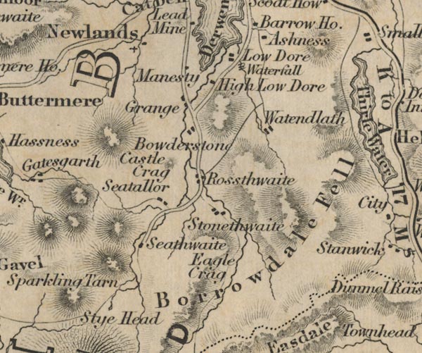 FD02NY21.jpg "Castle Crag" Hill hachuring. item:- JandMN : 100.1 Image © see bottom of page |
|
|
|
||
| evidence:- | old drawing:- Aspland 1840s-60s |
|
| source data:- | Drawing, pencil, River Derwent and Castle Rock, Borrowdale, Cumberland, by Theophilus
Lindsey Aspland, 1857.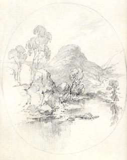 click to enlarge click to enlargeAS0524.jpg item:- Armitt Library : 1958.389.24 Image © see bottom of page |
|
|
|
||
| evidence:- | old drawing:- Aspland 1840s-60s |
|
| source data:- | Drawing, pencil, River Derwent and Castle Rock, Borrowdale, Cumberland, by Theophilus
Lindsey Aspland, 1857.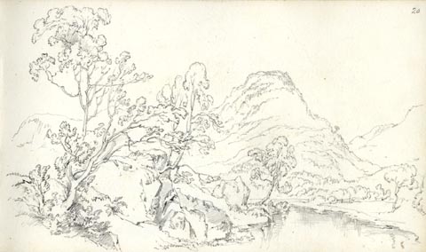 click to enlarge click to enlargeAS0525.jpg page number "20" item:- Armitt Library : 1958.389.25 Image © see bottom of page |
|
|
|
||
| evidence:- | old map:- Garnett 1850s-60s H placename:- Castle Crag |
|
| source data:- | Map of the English Lakes, in Cumberland, Westmorland and
Lancashire, scale about 3.5 miles to 1 inch, published by John
Garnett, Windermere, Westmorland, 1850s-60s.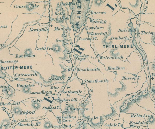 GAR2NY21.jpg "Castle Crag" hill hachuring item:- JandMN : 82.1 Image © see bottom of page |
|
|
|
||
| evidence:- | old text:- Martineau 1855 |
|
| source data:- | Guide book, A Complete Guide to the English Lakes, by Harriet
Martineau, published by John Garnett, Windermere, Westmorland,
and by Whittaker and Co, London, 1855; published 1855-76. goto source Page 81:- "... Grange, ... Just behind it, the noble wooded rock, which leaves room only for the road and the river, is Castle Crag; and nimble youths who have reached its summit, say the view is splendid. It is, in itself, a fine spectacle." |
|
|
|
||
| evidence:- | outline view:- Martineau 1855 |
|
| source data:- | Print, engraving, outline view, Mountains seen from Applethwaite near Keswick, drawn
by L Aspland, engraved by W Banks, Edinburgh, published by John Garnett, Windermere,
Westmorland, and by Whittaker and Co, London, 1855.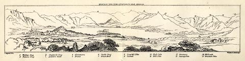 click to enlarge click to enlargeMNU114.jpg Plate, folded in opposite p.93 in A Complete Guide to the English Lakes, by Harriet Martineau. "MOUNTAINS SEEN FROM APPLETHWAITE NEAR KESWICK." "L Aspland Delt. / W Banks Sc Edinr." The view is captioned, numbers referring to mountains in the image:- "1 Wallow Crag, 2 Falcon Crag, 3 Shepherd's Crag / Lowdore below, 4 Glaramara, 5 Brund, 6 Castle Crag, 7 Great End, 8 Scawfell Pike, 9 Catbell, 10, High Stile, 11 Red Pike, 12 Grasmoor, 13 Causey Pike, 14 Melbreak, 15 Grisdale Pike" item:- Armitt Library : A1159.14 Image © see bottom of page |
|
|
|
||
| evidence:- | old photograph:- Bell 1880s-1940s |
|
| source data:- | Photograph, sepia, the Castle Crag, Borrowdale, Cumberland, by Herbert Bell, Ambleside,
Westmorland, 1890s.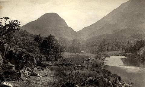 click to enlarge click to enlargeHB0380.jpg internegative at lower left:- "[H. B ]" item:- Armitt Library : ALPS34 Image © see bottom of page |
|
|
|
||
| evidence:- | old photograph:- Bell 1880s-1940s |
|
| source data:- | Photograph, black and white, Castle Crag, and Gates Crag perhaps Goat Crag, Borrowdale,
Cumberland, by Herbert Bell, Ambleside, Westmorland, 1890s.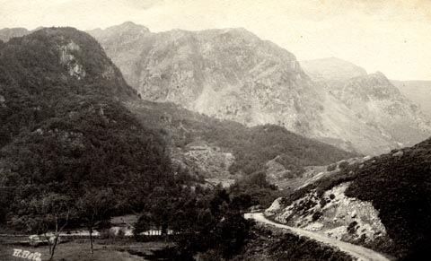 click to enlarge click to enlargeHB0381.jpg internegative at lower left:- "H. Bell" item:- Armitt Library : ALPS35 Image © see bottom of page |
|
|
|
||
| evidence:- | illustration:- LNWR 1910 |
|
| source data:- | Print, colour lithograph? Castle Crag, Borrowdale, from a
painting by R T Roussel, published by the London and North
Western Railway, LNWR, about 1910.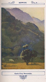 click to enlarge click to enlargeNW01E6.jpg Included in the guide book, The English Lakes, published by the London and North Western Railway about 1910. Roussel, R T, 1910item:- JandMN : 49.7 Image © see bottom of page |
|
|
|
||
| evidence:- | outline view:- Jenkinson 1875 placename:- Castle Crag |
|
| source data:- | Print, lithograph, outline view, Panoramic Sketches from Skiddaw, Cumberland, by Edwin
A Pettitt, London, published by Edward Stanford, 55 Charing Cross, London, 1875. click to enlarge click to enlargeJk01E2.jpg "... Castle Crag ..." item:- JandMN : 28.8 Image © see bottom of page |
|
|
|
||
| evidence:- | outline view:- Jenkinson 1875 placename:- Castle Crag |
|
| source data:- | Print, lithograph, outline view, Panoramic Sketches from Scawfell Pike, Cumberland,
by Edwin A Pettitt, London, published by Edward Stanford, 55 Charing Cross, London,
1875. click to enlarge click to enlargeJk01E3.jpg "... Castle Crag ..." item:- JandMN : 28.9 Image © see bottom of page |
|
|
|
||
| evidence:- | outline view:- Black 1856 (23rd edn 1900) placename:- Castle Crag |
|
| source data:- | Print, lithograph, Outline Views, Skiddaw and Derwent Water - Mountains as seen at
Lodore Hotel, and Mountains as seen at the Third Gate on Ascending Latrigg on the
Way to Skiddaw, by J Flintoft, Keswick, Cumberland, engraved by R Mason, Edinburgh,
Lothian, about 1900.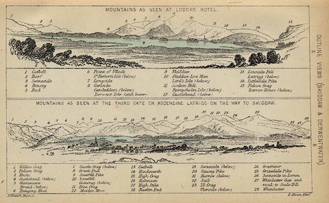 click to enlarge click to enlargeBC08E4.jpg "... 7 Castle Crag ..." item:- JandMN : 37.14 Image © see bottom of page |
|
|
|
||
| evidence:- | outline view:- Black 1841 (3rd edn 1846) placename:- Castle Crag |
|
| source data:- | Print, engraving, outline view, Mountains as seen at Lowdore Inn, and Mountains as
seen at the Third Gate on Ascending Latrigg on the Way to Skiddaw, by J Flintoft,
Keswick, Cumberland, engraved by R Mason, Edinburgh, Lothian, about 1846.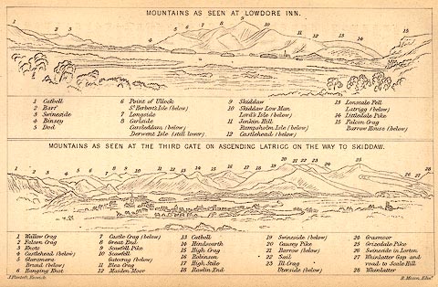 click to enlarge click to enlargeBC02E4.jpg "... 7 Castle Crag ..." item:- JandMN : 32.7 Image © see bottom of page |
|
|
|
||
| evidence:- | outline view:- Tattersall 1836 placename:- Castle Crag |
|
| source data:- | Print, engraving, Derwentwater and Entrance to Borrowdale, Cumberland, drawn by George
Tattersall, engraved by W F Topham, published by Sherwood and Co, Paternoster Row,
London, about 1836.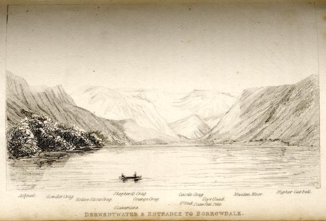 click to enlarge click to enlargeTAT120.jpg The print is captioned with mountain names and acts as an outline view. Tipped in opposite p.60 of The Lakes of England, by George Tattersall. printed at bottom:- "DERWENTWATER &ENTRANCE TO BORROWDALE." printed at bottom left to right:- "Ashness. / Gowder Crag. / Hollow Stone Crag. / Glaramara. / Shepherd's Crag. / Grange Crag. / Castle Crag. / Gt. End. / Scawfell Pike. / Maiden Moor. / Higher Catbell." item:- Armitt Library : A1204.21 Image © see bottom of page |
|
|
|
||
| evidence:- | old print:- Rose 1832-35 (vol.1 no.71) placename:- Castle Crag |
|
| source data:- | Print, uncoloured engraving, Castle Crag, Borrowdale, from the Village of Grange,
Cumberland, drawn by Thomas Allom, engraved by J C Bentley, published by Fisher, Son
and Co, London, 1832-35.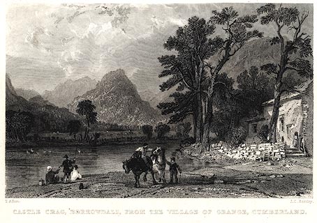 click to enlarge click to enlargePR0026.jpg vol.1 pl.71 in the set of prints, Westmorland, Cumberland, Durham and Northumberland Illustrated. printed at bottom left, right, centre:- "T. Allom. / J. C. Bentley. / CASTLE CRAG, BORROWDALE, FROM THE VILLAGE OF GRANGE, CUMBERLAND." item:- Dove Cottage : 2008.107.26 Image © see bottom of page |
|
|
|
||
| evidence:- | old print:- placename:- Castle Crag |
|
| source data:- | Print, uncoloured engraving, Castle Crag, near Keswick, Cumberland, drawn by Havell,
engraved by Backshell, published 1820s-30s?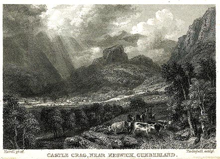 click to enlarge click to enlargePR0264.jpg printed at bottom left, right, centre:- "Havell, pinxt. / Backshell, sculpt. / CASTLE CRAG, NEAR KESWICK, CUMBERLAND." item:- Dove Cottage : 2008.107.264 Image © see bottom of page |
|
|
|
||
| evidence:- | old print:- Green 1790s-1820s placename:- Castle Crag |
|
| source data:- | Print, uncoloured aquatint, Skiddaw, taken near Castle Crag, Underskiddaw, Cumberland,
drawn, engraved and published by William Green, Ambleside, 1804.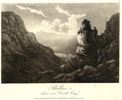 click to enlarge click to enlargePR0516.jpg Plate 18 from some series. printed at bottom:- "Skiddaw, / taken near Castle Crag. / Drawn and Engraved by Wm. Green, and Published at Ambleside, June 24, 1804." item:- Dove Cottage : 2008.107.465 Image © see bottom of page |
|
|
|
||
 BWB21.jpg Trees on top. (taken 6.3.2012) 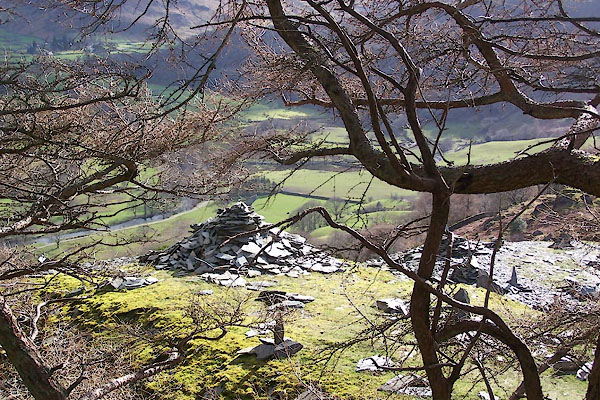 BWB25.jpg Cairn, not on top. (taken 6.3.2012) |
||
|
|
||
Lakes Guides menu.