 Old Cumbria Gazetteer
 |
 |
|
| Askerton Castle, Askerton | ||
| Askerton Castle | ||
| civil parish:- | Askerton (formerly Cumberland) | |
| county:- | Cumbria | |
| locality type:- | castle | |
| locality type:- | pele tower (?) | |
| coordinates:- | NY55036927 | |
| 1Km square:- | NY5569 | |
| 10Km square:- | NY56 | |
|
|
||
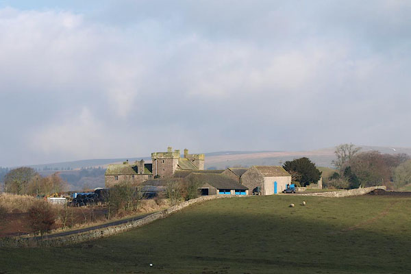 BSE25.jpg (taken 19.2.2010) 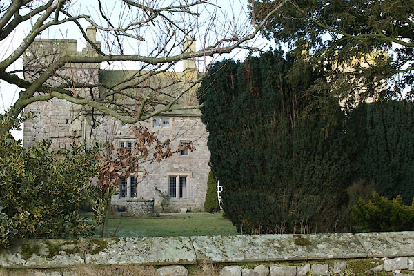 BSE28.jpg (taken 19.2.2010) |
||
|
|
||
| evidence:- | old map:- OS County Series (Cmd 12 2) placename:- Askerton Castle |
|
| source data:- | Maps, County Series maps of Great Britain, scales 6 and 25
inches to 1 mile, published by the Ordnance Survey, Southampton,
Hampshire, from about 1863 to 1948. |
|
|
|
||
| evidence:- | old map:- Saxton 1579 placename:- Askerton Castle |
|
| source data:- | Map, hand coloured engraving, Westmorlandiae et Cumberlandiae Comitatus ie Westmorland
and Cumberland, scale about 5 miles to 1 inch, by Christopher Saxton, London, engraved
by Augustinus Ryther, 1576, published 1579-1645. Sax9NY56.jpg Building with two towers, symbol for a castle. "Askerton cast:" item:- private collection : 2 Image © see bottom of page |
|
|
|
||
| evidence:- | old map:- Mercator 1595 (edn?) placename:- Askerton Castle |
|
| source data:- | Map, hand coloured engraving, Northumbria, Cumberlandia, et
Dunelmensis Episcopatus, ie Northumberland, Cumberland and
Durham etc, scale about 6.5 miles to 1 inch, by Gerard Mercator,
Duisberg, Germany, about 1595. MER8CumA.jpg "Askerton Ca." circle, building and tower item:- JandMN : 169 Image © see bottom of page |
|
|
|
||
| evidence:- | old map:- Speed 1611 (Cum/EW) placename:- Castle Askerton |
|
| source data:- | Map, hand coloured engraving, Kingdome of Great Britaine and
Ireland, scale about 36 miles to 1 inch, by John Speed, about
1610-11, published by Thomas Bassett, Fleet Street and Richard
Chiswell, St Paul's Churchyard, London, 1676? click to enlarge click to enlargeSPD6Cm.jpg "Ca. Askerton" dot, circle, and tower item:- private collection : 85 Image © see bottom of page |
|
|
|
||
| evidence:- | old map:- Speed 1611 (Cmd) placename:- Askerton Castle |
|
| source data:- | Map, hand coloured engraving, Cumberland and the Ancient Citie
Carlile Described, scale about 4 miles to 1 inch, by John Speed,
1610, published by J Sudbury and George Humble, Popes Head
Alley, London, 1611-12.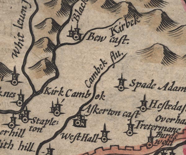 SP11NY57.jpg "Askerton cast" circle, buildings, tower item:- private collection : 16 Image © see bottom of page |
|
|
|
||
| evidence:- | perhaps old map:- Jenner 1643 placename:- Askerton |
|
| source data:- | Tables of distances with a maps, Westmerland, scale about 16
miles to 1 inch, and Cumberland, scale about 21 miles to 1 inch,
published by Thomas Jenner, London, 1643; published 1643-80. JEN4Sq.jpg "Askerton" circle |
|
|
|
||
| evidence:- | old map:- Jansson 1646 placename:- Askerton Castle |
|
| source data:- | Map, hand coloured engraving, Cumbria and Westmoria, ie
Cumberland and Westmorland, scale about 3.5 miles to 1 inch, by
John Jansson, Amsterdam, Netherlands, 1646.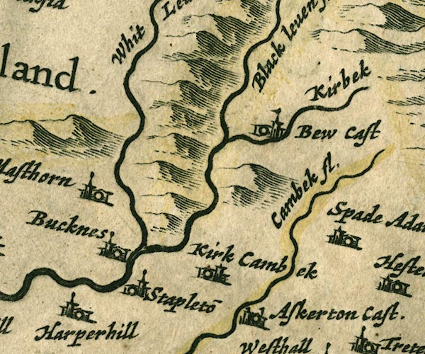 JAN3NY57.jpg "Askerton Cast." Buildings and tower with flag. item:- JandMN : 88 Image © see bottom of page |
|
|
|
||
| evidence:- | old map:- Sanson 1679 placename:- Askerton |
|
| source data:- | Map, hand coloured engraving, Ancien Royaume de Northumberland
aujourdhuy Provinces de Nort, ie the Ancient Kingdom of
Northumberland or the Northern Provinces, scale about 9.5 miles
to 1 inch, by Nicholas Sanson, Paris, France, 1679. click to enlarge click to enlargeSAN2Cm.jpg "Askerton" circle, building and tower, flag; town? item:- Dove Cottage : 2007.38.15 Image © see bottom of page |
|
|
|
||
| evidence:- | old map:- Morden 1695 (Cmd) placename:- Askerton Castle |
|
| source data:- | Map, uncoloured engraving, Cumberland, scale about 4 miles to 1
inch, by Robert Morden, 1695, published by Abel Swale, the
Unicorn, St Paul's Churchyard, Awnsham, and John Churchill, the
Black Swan, Paternoster Row, London, 1695-1715.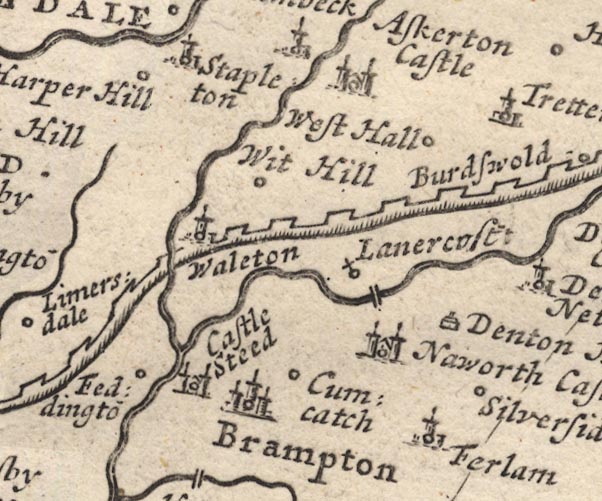 MD12NY56.jpg "Askerton Castle" Circle, building with two towers. item:- JandMN : 90 Image © see bottom of page |
|
|
|
||
| evidence:- | old map:- Badeslade 1742 placename:- Askerton Castle |
|
| source data:- | Map, uncoloured engraving, A Map of Cumberland North from
London, scale about 11 miles to 1 inch, with descriptive text,
by Thomas Badeslade, London, engraved and published by William
Henry Toms, Union Court, Holborn, London, 1742. click to enlarge click to enlargeBD10.jpg "Askerton Cast" circle, italic lowercase text; castle item:- JandMN : 115 Image © see bottom of page |
|
|
|
||
| evidence:- | old map:- Bowen and Kitchin 1760 placename:- Askerton Castle |
|
| source data:- | Map, hand coloured engraving, A New Map of the Counties of
Cumberland and Westmoreland Divided into their Respective Wards,
scale about 4 miles to 1 inch, by Emanuel Bowen and Thomas
Kitchin et al, published by T Bowles, Robert Sayer, and John
Bowles, London, 1760.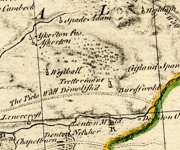 BO18NY66.jpg "Askerton Cas." circle and line; there is also a circle and line for "Askerton" which hardly exists as a separate settlement? unless this indicates the parish. item:- Armitt Library : 2008.14.10 Image © see bottom of page |
|
|
|
||
| evidence:- | old text:- Pennant 1773 |
|
| source data:- | Book, A Tour from Downing to Alston Moor, 1773, by Thomas
Pennant, published by Edward Harding, 98 Pall Mall, London, 1801. goto source goto sourcePennant's Tour 1773, page 180 "I crossed a very barren unfrequented country northward, hilly, and covered with coarse grass; passed by Askerton-hall, an old house with two towers built by one of the Lord Dacres, who placed here a garrison, under the command of the Governor of Gillesland, who had the title of Land Serjeant." |
|
|
|
||
| evidence:- | old map:- Donald 1774 (Cmd) |
|
| source data:- | Map, hand coloured engraving, 3x2 sheets, The County of Cumberland, scale about 1
inch to 1 mile, by Thomas Donald, engraved and published by Joseph Hodskinson, 29
Arundel Street, Strand, London, 1774. D4NY56NE.jpg "Castle / Askerton" large building; a castle item:- Carlisle Library : Map 2 Image © Carlisle Library |
|
|
|
||
| evidence:- | old text:- Clarke 1787 placename:- Askerton Castle |
|
| source data:- | Guide book, A Survey of the Lakes of Cumberland, Westmorland,
and Lancashire, written and published by James Clarke, Penrith,
Cumberland, and in London etc, 1787; published 1787-93. goto source Page 105:- "..." "I do not find any ancient authors mention a castle here [Castlerigg], Speed, who speaks of twenty-five in Cumberland, hath found out every one I ever heard or knew of, except Kirkoswald; how that has escaped him I cannot tell. I shall here put down their names, and, as well as I can, their most ancient owners, and supposed founders." "..." goto sourcePage 106:- "..." "2. ASKERTON. Founded by one of that name in Edward I's. time." "..." |
|
|
|
||
| evidence:- | old text:- Camden 1789 placename:- Askerton Castle |
|
| source data:- | Book, Britannia, or A Chorographical Description of the Flourishing Kingdoms of England,
Scotland, and Ireland, by William Camden, 1586, translated from the 1607 Latin edition
by Richard Gough, published London, 1789. goto source Page 176:- "... the little river Cambec ... on whose banks the barons Dacre built the little castle of Askerton, where the warden or land-sergeant of Gillesland has a garrison. ..." |
|
|
|
||
| evidence:- | database:- Listed Buildings 2010 placename:- Askerton Castle |
|
| source data:- | courtesy of English Heritage "ASKERTON CASTLE / / / ASKERTON / CARLISLE / CUMBRIA / I / 78109 / NY5500869208" |
|
|
|
||
| evidence:- | database:- Listed Buildings 2010 |
|
| source data:- | courtesy of English Heritage "BYRES TO SOUTH EAST OF ASKERTON CASTLE / / / ASKERTON / CARLISLE / CUMBRIA / II / 78113 / NY5506469256" |
|
|
|
||
| evidence:- | database:- Listed Buildings 2010 |
|
| source data:- | courtesy of English Heritage "BARN AND BYRES TO SOUTH WEST OF ASKERTON CASTLE / / / ASKERTON / CARLISLE / CUMBRIA / II / 78110 / NY5504269225" |
|
|
|
||
| evidence:- | old painting:- placename:- Askerton Castle |
|
| source data:- | Painting, watercolour, Askerton Castle, Cumberland, by William James Blacklock, 1844.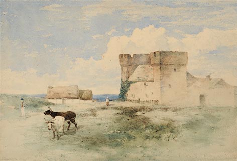 click to enlarge click to enlargePR0945.jpg In foreground two cows are led by a farm worker across rough grassland; beyond stands Askerton Castle and beside it a low thatched cottage with female figure standing between the two. signed at bottom left:- "W J Blacklock 1844" inscribed reverse at top centre:- "Askerton Castle Cumberland" inscribed reverse at top right:- "Mr Wilkinson Scotby" item:- Tullie House Museum : 1946.67.13 Image © Tullie House Museum |
|
|
|
||
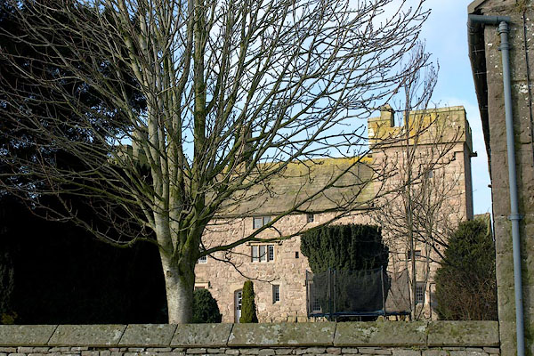 BSE26.jpg (taken 19.2.2010) 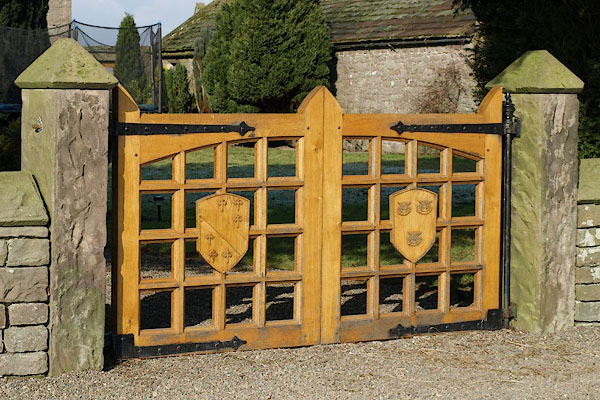 BSE27.jpg Gates, with coats of arms ?Howard and ?Dacre families? (taken 19.2.2010) 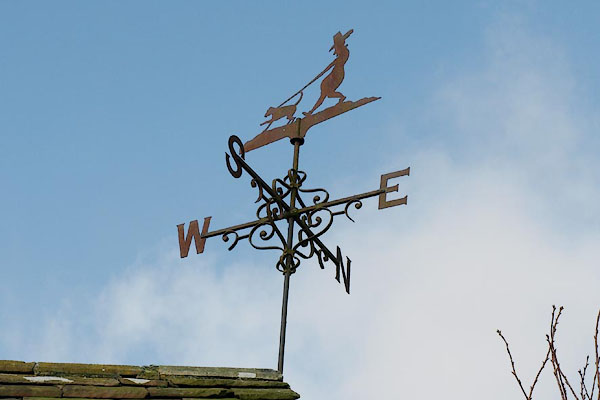 BSE30.jpg Weathervane. (taken 19.2.2010) |
||
|
|
||
| hearsay:- |
The hall is of a fortified manor house, 15th century, and still has its original roof.
The towers at each end were added in the 16th century; and there are recent alterations.
Closed to visits. |
|
| Belted Will lived here when he was Warden of the Marches. |
||
|
|
||
| notes:- |
towers, hall, gateway |
|
| Perriam, D R &Robinson, J: 1998: Medieval Fortified Buildings of Cumbria: CWAAS::
ISBN 1 873124 23 6; plan and illustration |
||
|
|
||
Lakes Guides menu.