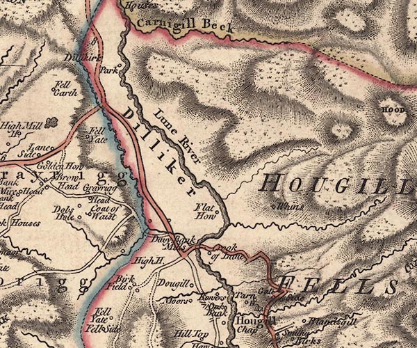
 Jefferys 1770 SD69NW

|

|
|
|
gazetteer links places may or may not be labelled on the map |
||

|
-- Birchfield -- "Birk Field" |
|
|
|
-- Bowers -- "Bowers" |
|
|
|
-- Coat o' West -- "Coat of Waist" |
|
|
|
-- Crook of Lune Bridge |
|
|
|
-- Crook of Lune -- "Crook of Lune" |
|
|
|
-- Davybank Mill -- "Davy Bank Mills" |
|
|
|
-- Dillicar -- "Dilliker" |
|
|
|
-- Dob's Hole -- "Dobs Hole" |
|
|
|
-- Dowgill -- "Dougill" |
|
|
|
-- Ellergill Beck |
|
|
|
-- Fell Gate -- "Fell Yate" |
|
|
|
-- Fleet Holme -- "Flat How" |
|
|
|
-- Gate Side -- "Gate Side" |
|
|
|
-- Grayrigg Head -- "Grayrigg Head" |
|
|
|
-- High House -- "High H." |
|
|
|
-- High Park -- "Dillikirk Park" |
|
|
|
-- Howgill Fells-- Howgill Fells -- "HOUGILL FELLS" |
|
|
|
-- Howgill Lane |
|
|
|
-- Low Park -- "Dillikirk Park" |
|
|
|
-- Lummer Gill |
|
|
|
-- Lune, River -- "Lune River" |
|
|
|
-- Moors -- "Moors" |
|
|
|
-- Oakbank -- "Oak Bank" |
|
|
|
-- Kendal to Tebay |
|
|
|
-- Crook of Lune road |
|
|
|
-- Tarnhouse Barn -- "Tarn H" |
|
|
|
-- Whin's -- "Whins" |
|
|
civil parishes The area roughly includes parts of parishes:- Grayrigg Lambrigg Firbank Tebay Orton S Sedbergh |
||
|
|
||
|
|
Lakes Guides menu. | |