 Jansson 1646 NY45


|

|
|
|
gazetteer links places may or may not be labelled on the map |
||

|
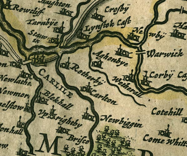
-- Aglionby -- "Aghonbye" |
|
|
|
-- Blackwell Hall -- "Blekhall" |
|
|
|
-- Botcherby -- "Rotherbÿ" |
|
|
|
-- Brunstock Beck |
|
|
|
-- Caldew, River -- "Canda fl." |
|
|
|
-- Carleton -- "Carlton" |
|
|
|
-- Carlisle -- "CARLILE" |
|
|
|
-- Corby Castle -- "Corbÿ Cast" |
|
|
|
-- Eden, River -- "Eden flude" -- "Eden flu."
-- "Eden flud" |
|
|
|
-- Hadrian's Wall -- "THE PICTS WAL." -- "THE
PICTS WAL." |
|
|
|
-- Irthing, River -- "Ireingh fl." |
|
|
|
-- Linstock Castle -- "Lynstok Cast" |
|
|
|
-- Newbiggin House -- "Newbiggin" |
|
|
|
-- Newby East -- "Newbÿ" |
|
|
|
-- Petteril, River -- "Pettevell fl." |
|
|
|
-- Pow Maughan |
|
|
|
-- Stanwix -- "Sta[]wix" |
|
|
|
-- Tarraby -- "Tarnbÿe" |
|
|
|
-- Upperby -- "Uprightby" |
|
|
|
-- Warwick Bridge |
|
|
|
-- Warwick -- "Warwick" |
|
|
|
-- Wetheral -- "Wetherall" |
|
|
civil parishes The area roughly includes parts of parishes:- Hayton Cumwhitton Brampton St Cuthbert Without Carlisle Stanwix Rural Wetheral Irthington |
||
|
|
||
|
|
Lakes Guides menu. | |