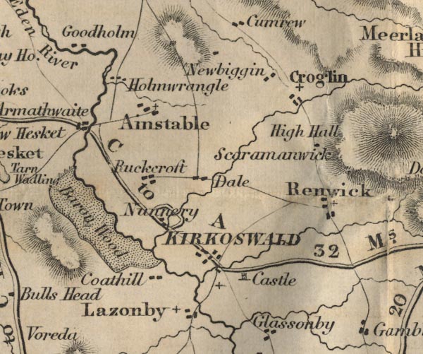
 Ford 1839 map NY54


|

|
|
|
gazetteer links places may or may not be labelled on the map |
||

|
-- Ainstable -- "Ainstable" |
|
|
|
-- Armathwaite -- "Armathwaite" |
|
|
|
-- Baronwood Park -- "Barou Wood" |
|
|
|
-- Cotehill -- "Coathill" |
|
|
|
-- Croglin Low Hall -- "High Hall" |
|
|
|
-- Croglin -- "Croglin" |
|
|
|
-- Dale Mill -- "Dale" |
|
|
|
-- Holmwrangle -- "Holmwrangle" |
|
|
|
-- Kirkoswald Castle -- "Castle" |
|
|
|
-- Kirkoswald -- "KIRKOSWALD" |
|
|
|
-- Lazonby -- "Lazonby" |
|
|
|
-- Low Holme -- "Goodholm" |
|
|
|
-- Newbiggin -- "Newbiggin" |
|
|
|
-- Nunnery -- "Nunnery" |
|
|
|
-- Renwick -- "Renwick" |
|
|
|
-- Carlisle to Alston -- "C to A 32 Ms." |
|
|
|
-- Ruckcroft -- "Puckcroft" |
|
|
|
-- Scarrowmanwick -- "Scaramanwick" |
|
|
civil parishes The area roughly includes parts of parishes:- Glassonby Lazonby Ainstable Cumwhitton Wetheral Cumrew Kirkoswald Hesket |
||
|
|
||
|
|
Lakes Guides menu. | |