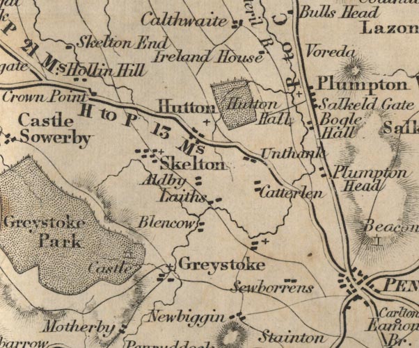
 Ford 1839 map NY43


|

|
|
|
gazetteer links places may or may not be labelled on the map |
||

|
-- Auldby -- "Aldby" |
|
|
|
-- Blencow -- "Blencow" |
|
|
|
-- Boggle Hall -- "Bogle Hall" |
|
|
|
-- Brackenburgh -- "Ireland House" |
|
|
|
-- Catterlen -- "Catterlen" |
|
|
|
-- Crown Point -- "Crown Point" |
|
|
|
-- Greystoke Castle -- "Greystoke Park" --
"Castle" |
|
|
|
-- Greystoke -- "Greystoke" |
|
|
|
-- Holly Hill -- "Hollin Hill" |
|
|
|
-- Hutton End -- "Hutton" |
|
|
|
-- Hutton-in-the-Forest -- "Hutton Hall" |
|
|
|
-- Laithes -- "Laiths" |
|
|
|
-- Plumton Head -- "Plumpton Head" |
|
|
|
-- Plumpton Wall -- "Plumpton Wall" |
|
|
|
-- Plumpton -- "Salkeld Gate" |
|
|
|
-- Penrith to Carlisle -- "P to C 18 Ms." |
|
|
|
-- Penrith to Hesket Newmarket -- "H to P 13 Ms." |
|
|
|
-- Penrith to Wigton -- "W to P 21 Ms." |
|
|
|
-- Sewborwens -- "Sewborrens" |
|
|
|
-- Skelton -- "Skelton" |
|
|
|
-- Unthank -- "Unthank" |
|
|
civil parishes The area roughly includes parts of parishes:- Greystoke Mungrisdale Dacre Catterlen Skelton Penrith Castle Sowerby Hesket |
||
|
|
||
|
|
Lakes Guides menu. | |