 Crosthwaite 1783-94, tetrad SD39J

|

|
|
|
gazetteer links places may or may not be labelled on the map |
||

|
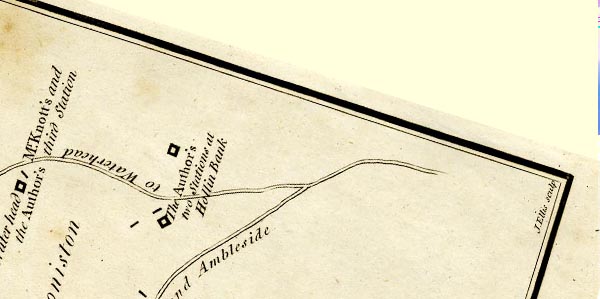
-- High Hollin Bank -- "The Author's two Stations at Hollin
Bank" -- "... Hollin Bank, half a Mile to the N.E. of
the Head of the Lake on the road from Hawkshead to Waterhead
..." |
|
|
|
-- Hollin Bank Farm -- "The Author's two Stations at Hollin
Bank" -- "... Hollin Bank, half a Mile to the N.E. of
the Head of the Lake on the road from Hawkshead to Waterhead
..." |
|
|
|
-- Ambleside to Coniston -- "to Waterhead and
Broughton" |
|
|
|
-- Coniston Water -- "The Author's two Stations at Hollin
Bank" -- "... are near Hollin Bank, half a Mile to the
N.E. of the Head of the Lake on the road from Hawkshead to
Waterhead ..." |
|
|
|
-- Coniston Water -- "The Author's two Stations at Hollin
Bank" -- "... are near Hollin Bank, half a Mile to the
N.E. of the Head of the Lake on the road from Hawkshead to
Waterhead ..." |
|
|
civil parishes The area roughly includes parts of parishes:- Coniston Hawkshead |
||
|
|
||
|
|
Lakes Guides menu. | |