 Clarke 1787 map, tetrad NY31Y
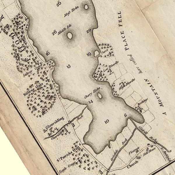

|

|
|
|
gazetteer links Places may or may not be labelled on the map. |
||

|
-- "Low Blawike" -- Blowick |
|
|
|
-- "Cherry Holm" -- Cherry Holm |
|
|
|
-- "Glenridding Beck" -- Glenridding Beck |
|
|
|
-- Glenridding Bridge |
|
|
|
-- "Glenridding" -- Glenridding |
|
|
|
-- "Coldrill Beck" -- Goldrill Beck |
|
|
|
-- Goldrill Bridge |
|
|
|
-- "Grisdale Beck" -- Grisedale Beck |
|
|
|
-- "Nell House" -- Nell House |
|
|
|
-- Patterdale |
|
|
|
-- "Place Fell" -- Place Fell |
|
|
|
-- "Purse" -- Purse Point |
|
|
|
-- "Vicarage" -- Rectory, The |
|
|
|
-- Kirkstone to Patterdale |
|
|
|
-- Patterdale to Penrith |
|
|
|
-- St Patrick's Church |
|
|
|
-- "St Patrick's Well" -- St Patrick's Well |
|
|
|
-- "Stibray Cragg" -- Stybarrow Crag |
|
|
|
-- "Stibray Oaks" -- Stybarrow Oaks |
|
|
|
-- "Middle Isle" -- Wall Holm |
|
|
civil parishes The area roughly includes parts of parishes:- Patterdale |
||
|
|
||
|
|
Lakes Guides menu. | |