 Whellan 1858

|

|
|
|
item:- Threlkeld Mining Museum (1) image:- © see bottom of page |
click to enlarge |
|
|
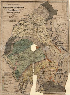
Geological map, Map of the Counties of Cumberland and
Westmoreland ... Geologically Coloured, scale about 3.5
miles to 1 inch, drawn and engraved by W Banks, Edinburgh,
Lothian, published by William Whellan and Co, 1858.
Interpreting the inscription bottom centre, this map might have been issued in Whellan's History and Topography of Cumberland and Westmoreland? |
||

|
Whellan 1858 | |
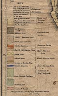
| map feature:- | table of symbols & north point & up is N & scale line & lat and long scales (2d 15m to 3d 38m W; 54d 3m to 55d 11m N) & sea plain & coast form lines & rivers & lakes & relief (minimal) & hill hachuring & settlements & roads (distinguished in the table of symbols as Main Roads, Cross Roads, Mountain Roads and Foot Roads) & railways & canals & geology & stratigraphical column | |
| inscription:- |
printed upper left
MAP OF THE COUNTIES / OF / CUMBERLAND & WESTMORELAND / INCLUDING THE WHOLE OF THE / Lake District / GEOLOGICALLY COLOURED. / By William Whelland and Co. / 1858 |
|
| inscription:- |
printed bottom left, centre, right
DRAWN & ENGRAVED BY W. BANKS, EDINR. / PUBLISHED WITH W WHELLAN[ ] / Entere[ ] |
|
| scale line:- | 5 miles = 36.7 mm | |
| scale:- | 1 to 220000 ? (1 to219257 from scale line) | |
| wxh, sheet:- | 44x60cm | |
| wxh, map:- | 426x578mm (approx) | |
|
||