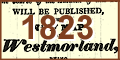
 Greenwood and Hodgson, Westmorland Gazette
1823
Greenwood and Hodgson, Westmorland Gazette
1823

|

|
|
|
|
Greenwood and Hodgson, Westmorland Gazette 1823 Transcripts of advertisements and letters in the Westmorland Gazette and the Kendal Chronicle, a controversy between C Greenwood and T Hodgson, surveyors of Westmorland maps, 1823. source type: Westmorland Gazette 1823 source type: Kendal Chronicle 1823 The newspaper titles are the Westmorland Gazette and Kendal Advertiser, referred to as the Westmorland Gazette, and the Westmorland Advertiser and Kendal Chronicle, referred to as the Kendal Chronicle. The correspondence mostly proceeds in parallel in both newspapers, though there are parts in one or the other not in the other or one. Transcription The transcripts are made from microfiche images, of variable legibility, of an incomplete series of newspapers; and from old photocopies of newscuttings found in the library files, also of variable legibility, which include copies of more newspapers than survive in microfiche. Where the photocopy is the only version there is no clue where the letter appeared in the newspaper, nor what order letters appeared in one issue - though this is irrelevant, a letter in an issue cannot be a response to a letter in the same issue. The articles appearing in both the newspapers are almost exactly the same, with minor differences of typesetting. The articles common to both newspapers are transcribed mostly from the Westmorland Gazetter, perhaps with illegible bits filled in from the Kendal Chronicle, always indicated by square brackets [ ] for inferred data. Italics are abandoned; hyphenation is closed up where possible. |
|||
|
Argument, and Libel? The matter transcribed is sometimes an advertisement, and sometimes a letter perhaps appearing as an advertisement, which had to be paid for. An issue of the newspaper might include more than one letter, which confuses the sequence of the arguments; the response to last weeks letter might be later on a page than a new letter in this weeks. The arguments themselves are confused by the rhetoric of the writers. The tone of writing seems near to libel, but the possibility of going to law over libel is rarely raised, sometimes just in veiled threats. An added problem of evidence is that neither surveyor wants to upset an individual subscriber by mentioning their name. How much can anything be believed in this lively debate? |
|||
|
Summary An attempt has been made to see the content of each letter, free of the rhetoric and bombast. Several themes have been identified, and comments made on them for each letter:- |
|||
| ADVERTISEMENT |
straightforward advertisement of a project.
|
||
| SUBSCRIBERS |
about lists of subscribers and how the patronage was
acquired.
|
||
| ABANDONMENT OF SURVEY |
CG's offer to buy out TH.
|
||
| RUMOURS |
rumours said to have been spread by CG about TH giving
up.
|
||
| PRIOR CLAIM |
CG's declaration to have a prior claim to survey
Westmorland.
|
||
| SURVEYING METHODS |
chains, trigonometrical survey, etc.
|
||
| THE MAPS |
how good the resultant maps will be.
|
||
| PRIOR KNOWLEDGE |
who knew who was doing what and when.
|
||
| GRAND SCHEME |
CG's overall scheme for a consistent Atlas of all
Counties in England and Wales.
|
||
| MAP SCALE |
silly argument about how much bigger one and a third is
than one.
|
||
| NEW OFFICE |
Greenwood and Co in Lancaster.
|
||
| AN ACRE OF GRAZING |
an unrelated problem addressed to both surveyors.
|
||
|
There is little hope of ever judging the true rights and
wrongs of the issues. Thomas Hodgson, perhaps, did not
choose a good time to begin a survey of the county.
Greenwood and Co were, probably, rather too full of
themselves and their grand scheme to map all the counties,
and, perhaps, over confident in dealing with a smaller local
surveyor. Some interesting glimpses are provided by the
letters into the methods of surveying in the 1820s, and into
the manners of professional gentlemen.
|
|||
|
The Maps |
|||
| Greenwood 1824 |
Map of the County of Westmorland, scale about 1 inch to 1
mile, by C and J Greenwood, published by George Pringle jnr,
70 Queen Street, Cheapside, London, 1823.
|
||
| Hodgson 1828 |
Plan of the County of Westmorland, scale about 1 1/3
inches to 1 mile, by Thomas Hodgson, engraved by W R
Gardner, Harpur Street, London, published by Thomas Hodgson,
Lancaster, and perhaps by C Smith, 172 Strand,
London,1828.
|
||
|
How do you choose between them? Both maps are shown in full in under Maps in the LakesGuides project.
Greenwood's three maps have been given a menu of their own. The coloured copy of Hodgson's map,
not available to us until 2017, has not been studied here in detail but deserves a thorough analysis.
|
|||
|
But a simple test was made by
looking at one area, the parish and valley of Longsleddale.
The position of features has not been checked; there are
some misplacements of houses across the river, but little of
consequence, and the overall shape has not been considered
at all. What is shown, and what is named has been compared
using a checklist already set up for studying maps in this
valley (my home). The results are tabulated:-
|
|||

|
-- spreadshet HDGGRW.xls | ||
|
Scores have been given to TH and CG: 1 if a feature is
shown; 2 if it is named correctly, allowing common variants
that were contemporary to the maps. Results:-
T Hodgson 95; C Greenwood 66; possible score 115
The minutiae on Thomas Hodgson's map win, and are not explained by his marginally larger scale, there is plenty of room on both maps for more. Thomas Hodgson's engraving of hill hachuring is less obtrusive, obscures less of other features and labels. The map images are:-
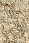 Hodgson 1828
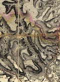 Greenwood 1824 |
|||
|
|
start here | ||
|
|
|||
Lakes Guides menu.