 Lakes Guides, topics
 |
 |
|
||
| trig points, Cumbria | ||||
| county:- | Cumbria | |||
| also see:- |  bench marks, Cumbria hills, Cumbria bench marks, Cumbria hills, Cumbria |
|||
|
|
||||
| What is there to see? |
||||
| Triangulation was used to map the land accurately using line of sight from visible
landmarks. What you can see are the trig points at the vertices of the triangulation
network. The sides of the triangles, like the equator, are notional, invisible lines
on the ground. |
||||
 BPS44.jpg 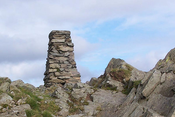 BPS46.jpg |
||||
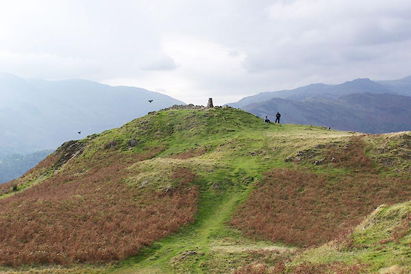
| The triangulation stations were made permanent, usually marked by 4 foot high pillars
of concrete or local stone, familar to any walker. They dot the tops of hills and
are often far from a road or track. |
||||
 BPK50.jpg |
||||
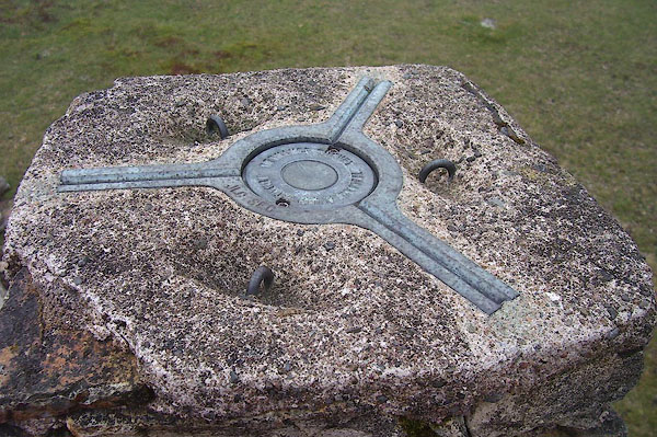
| The actual point is below ground, often fixed in the rock, protected and marked by
the pillar. The pillar is a practical stand for a theodolite, whose three legs fit
in the grooves on the bronze plate atop the pillar, and from which a plumb bob reaches
to the point below: there is a fundamental mark even deeper down. The pillar may carry
a bench mark. |
||||
| |
||||
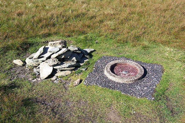
| Some trig points are more basic. |
||||
 BJT37.jpg |
||||
| Only trig points that we have visited are included in this website. Many more are
in the Ordnance Survey's list. Notice that positions are given by a 10 figure grid
reference, accurate to 1 metre. |
||||
|
|
||||
 Principal Triangulation Principal Triangulation |
||||
|
|
||||
| notes:- |
Early Sightings of Sappers at Work |
|||
| William Wordsworth, 1813, wrote about a surveyor on Black Combe:- |
||||
| "... on the summit whither thou art bound, A geographic Labourer pitched his tent, With books supplied and instruments of art, To measure height and distance; lonely task, Week after week pursued! - To him was given Full many a glimpse (but sparingly bestowed On timid man) of Nature's processes Upon the exalted hills. He made report That once, while there he plied his studious work, Within that canvas Dwelling, colours, lines, And the whole surface of the out-spread map. Became invisible: for all around Had darkness fallen - unthreatened, unproclaimed - As if the golden day itself had been Extiguished in a moment; total gloom In which he sate alone, with unclosed eyes, Upon the blinded mountain's silent top!" |
||||
|
|
||||
| Jonathan Otley's guide book, an account of a trip up Skiddaw in a a letter from a
friend:- |
||||
| :- |
"... Proceeding along this ridge, we unexpectedly heard the sound of human voices,
and presently descried some men engaged in building a large pile of stones around
a structure of timber thirty feet high, upon the very summit. They proved to be a
party of Royal Engineers and Artillerymen, who had been encamped here for several
days, employed in erecting an object to be observed in the Trigonometrical Survey;
as the Commanding Officer explained to us. Some philanthropic gentleman had caused
a small cot to be constructed here for the accommodation of visitants, and on looking
in we perceived that the men had spread their blankets on a little moss, and thus
converted it into a temporary barrack. ..." |
|||
| Otley 1823 (3rd edn 1827) |
||||
|
|
||||
| Jonathan Otley's guide book regarding Skiddaw:- |
||||
| :- |
"... the object of our journey, which is marked by a large pile of stones, with a central
staff 30 feet high, erected in 1826 by a detachment of the ordnance surveyors. ..." |
|||
| Otley 1823 (5th edn 1834) |
||||
|
|
||||
| Jonathan Otley's guide book regarding Scawfell Pike:- |
||||
| :- |
"... Latterly however, it seems by common consent, the highest point is called Scawfell-Pikes;
and since the erection of the large pile and staff upon it in 1826, there is no danger
of mistaking the place." |
|||
| "..." |
||||
| "... in towering majesty, the highest of the Pikes, rendered more conspicuous by an
object lately erected in the prosecution of the Trigonometrical Survey. ..." |
||||
| Otley 1823 (5th edn 1834) |
||||
|
|
||||
| Harriet Martineau, 1855, notes there is no longer any need to get lost on Scawfell
Pike:- |
||||
| :- |
"... The ascent of Scawfell ... ... The Ordnance surveyors set up a staff on a pile
of stones on the highest peak; so that there need be no mistake henceforth. ..." |
|||
| Martineau 1855 |
||||
|
|
||||
| Jonathan Otley's guide book regarding Black Combe:- |
||||
| :- |
"BLACK COMBE, OR COOM," |
|||
| "... may be seen at a great distance; ... In 1808, it was made one of Colonel Mudge's
stations, in the process of the Trigonometrical Survey. He calculated its height to
be 1919 feet above the level of the sea. ... By the misprint of a single figure in
the longitude of this mountain in the 3rd vol. of the Trigonometrical Survey, a great
distortion has been caused in some maps lately constructed upon that basis." |
||||
| Otley 1823 (5th edn 1834) |
||||
|
|
||||
| Harriet Martineau, 1855, comments about Colonel Mudge on Black Combe:- |
||||
| :- |
"... Col. Mudge's information that, when residing on Blackcombe for surveying purposes,
he more than once saw Ireland before sunrise, would bring strangers to try their luck
in seeing Scotland, Staffordshire, and Ireland, from the same point: but the mountain
lies out of the ordinary track of tourists, and very few visit it. ..." |
|||
| Martineau 1855 |
||||
|
|
||||
| Jonathan Otley complained to Sir George Airy, Asronomer Royal, about the damage done
by the Ordnance Survey engineers to the cistern on the top of Great Gable. The outcome
is explained in the last letters of this correspondence:- |
||||
| :- |
"Royal Observatory, Greenwich" |
|||
| "1854. October 5th." |
||||
| "Dear Sir,-" |
||||
| "Your complaints about the cistern on Great Gable have not fallen to the ground." |
||||
| "Since I last wrote to you, I have consulted with Dr. Leitch, who at my request, was
so kind as to undertake the practical management of the matter, and we have fairly
shifted the man ten feet to the Magnetic West. I have given notice of this to the
Ordnance Survey Office, so that no confusion will be produced in their bearings. As
you probably remember very well the former state of the cistern, perhaps you will
have the goodness to compare notes with Dr. Leitch, or with Mr. John Jackson, the
postmaster at Rosthwaite, who went up with Dr. Leitch and directed the wallers in
the work. I should be glad to know that the cistern had not suffered under the operations
of the Sappers of the Survey." |
||||
| "I am, dear Sir," |
||||
| "Yours truly," |
||||
| "G. B. Airy." |
||||
| and Jonathan Otley's reply:- |
||||
| "October 10th, 1854" |
||||
| "Yours of the 5th came duly to hand. Dr. Leitch called on me yesterday to say that
they had built a nice little man on the Gable, according to your directions. If you
had not distinctly mentioned magnetic West, I should have thought it would have been
true west, as I presume the Ordnance maps are laid down from the true meridian. He
says that he cannot perceive any damage that has been done to it ..." |
||||
| "Although I shall never see it, I am glad that it has been restored to its original
state, so that if ever it was worth looking at as a natural curiosity, it may still
continue the same. ..." |
||||
|
|
||||
| Harriet Martineau, 1855, complains about work on the Old Man of Coniston:- |
||||
| :- |
"... the summit of the Old Man is 2,632. On this rock, a "Man" formerly stood; but
it was removed by the Ordnance Surveyors, who erected another, much inferior in convenience;
for the first contained a chamber, welcome to shepherds and tourists overtaken by
bad weather. ..." |
|||
| Martineau 1855 |
||||
|
|
||||
| references:- |
: 1967: History the Retriangulation of Great Britain: Ordnance
Survey Clarke, A R: 1858: Account of the Observations of the Principal Triangulation: Ordnance Survey Close, Charles, Colonel Sir & Winterbotham, H StJ L, Colonel: 1925: Text Book of Topographical and Geographical Surveying: HMSO (London); how to do it all Frisius, Gemma: 1533: Libellus de locorum describendorum ratione::: British Library C113c3 (1-2) Harley, J B: 1975: Ordnance Survey: Ordnance Survey (Southampton, Hampshire) James, Henry: 1875: Account of the Methods and Processes... Ordnance Survey: HMSO (London) Keay, John: 2000: Great Arc, The: Harper Collins (London):: ISBN 0 00653123 7; describes what surveying can be like outside the comfort of Geat Britain. Owen, Tim & Pilbeam, Elaine: 1992: Ordnance Survey, Map Makers to Britain since 1791: Ordnance Survey (Southampton, Hampshire):: ISBN 0 319 00498 8 (pbk); includes desriptions of building trig points. |
|||
|
|
||||
Lakes Guides menu.