 Old Cumbria Gazetteer
 |
 |
|
| included in:- |
 trig points, Cumbria trig points, Cumbria |
|
| trig points, Cumbria: Principal Triangulation | ||
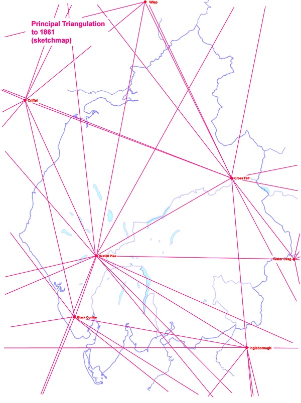 CumTrig.jpg |
||
|
|
||
| evidence:- | old text:- Clarke 1858 |
|
| source data:- | Notes from the Principal Triangulation, by Captain Alexander Ross Clarke, published
by the Ordnance Survey, London, 1858. "ORDNANCE TRIGONOMETRICAL SURVEY OF GREAT BRITAIN AND IRELAND, ACCOUNT OF THE OBSERVATIONS AND CALCULATIONS, OF THE PRINCIPAL TRIANGULATION; AND OF THE FIGURE, DIMENSIONS AND MEAN SPECIFIC GRAVITY, OF THE EARTH AS DERIVED THEREFROM. PUBLISHED BY ORDER OF THE MASTER-GENERAL AND BOARD OF ORDNANCE....." Relevant to Westmorland and Cumberland are:- |
|
| source data:- | Black Combe, Whicham "BLACK COMB, 1841, is a large rocky hill in the parish of Whitbeck, in the county of
Cumberland. The station is on top of the hill, and is marked by a pile of stones 14.5
feet high and 50 feet in circumference, erected above a centre stone with a hole in
it 4 inches deep and an inch in diameter. The station was restored in 1852." "BLACK COMB 2-ft. Theodolite From 31st August to 29th October 1841. Observer: Lieut. DA COSTA, R.E." "Objects / Bearings in degrees, minutes and decimal seconds.Snowdon / 20 46 45.34 South Berule / 82 42 22.61 Snea Fell / 90 56 40.86 North Berule / 93 24 58.62 Cairnsmuir of Fleet / 141 4 37.06 Merrick / 143 38 30.78 Ben Cairn / 151 3 28.87 Cairnsmuir on Deugh / 153 14 10.25 Dent Hill / 159 23 6.89 Criffel / 165 49 5.89 Sca Fell / 199 9 18.04 Little Whernside / 272 47 13.12 Ingleboro' / 279 7 41.59 Pendle Hill / 302 [17] 49.00 Whittle Hill / 312 54 35.48 Beryl / 337 54 38.61" "Altitude above mean sea level:-1974.3 feet" "Position, latitude and longitude, degrees minutes decimal seconds54 15 27.52 / 3 19 37.06" |
|
| source data:- | Criffel, Scotland "CRIFFEL, 1841. This station is on top and close to the south-west edge of 'Douglas
Cairn,' which is on the highest part of the well-known mountain named Criffel, 10
miles south of Dumfries, and 3 miles south of the village of New Abbey. It is marked
by a hole in the solid rock, in the centre of a square formed by four pickets on which
rested the instrument. A wall runs over the top of the mountain in a north-east and
south-west direction, forming an angle near the station, which is 80 feet due east
from the nearest point of the wall." "Altitude above mean sea level:-1866.6 feet" "Position, latitude and longitude, degrees minutes decimal seconds54 56 26.38 / 3 37 37.16" |
|
| source data:- | Cross Fell, Culgaith "CROSS FELL, 1841, is a remarkable mountain, about 9 miles south of Alston, in Cumberland.
The station is on its summit, and may be discovered by means of the stones placed
round the staff." "CROSS FELL 3-ft. Theodolite From 3rd October to 27th November 1841. Observer: Lieut. PIPON, R.E." "Objects / Bearings in degrees, minutes and decimal seconds.Sca Fell / 59 42 28.14 Helvellyn / 60 27 46.04 High Pike / 90 38 39.84 Ben Cairn / 102 1 22.25 Cairnsmuir of Fleet / 105 2 34.70 Criffel / 110 17 46.33 Merrick / 111 43 50.93 Cairnsmuir on Deugh / 119 49 31.27 Burnswark / 131 0 19.03 Hart Fell / 143 42 25.97 Wisp / 154 46 49.00 Dunrich / 155 34 44.83 Cheviot / 194 2 34.32 Collier Law / 256 50 10.58 Bolton Head / 289 27 25.84 Black Hambleton / 298 20 2.13 Water Crag / 320 28 22.19 Great Whernside / 332 5 31.69 Little Whernside / 354 4 8.57 Ingleboro' / 354 26 22.07" "Altitude above mean sea level:-2927.8 feet" "Position, latitude and longitude, degrees minutes decimal seconds54 42 10.76 / 2 29 6.73" |
|
| source data:- | Great Whernside, North Yorkshire "GREAT WHERNSIDE, 1840. This station is on the top of a conspicuous mountain a few
miles west from New Malton in the North Riding of Yorkshire." "Altitude above mean sea level:-2310.3 feet" "Position, latitude and longitude, degrees minutes decimal seconds54 9 39.04 / 1 59 48.04" |
|
| source data:- | Ingleborough, North Yorkshire "INGLEBOROUGH, 1807. This station is on top of the mountain of this name, 5 miles east
of Ingleton Village, in the West Riding of Yorkshire; it is about 60 yards from the
highest part of the an old building towards the north-east, which building is on the
nearest brink of Ingleborough from the station south-westward." "Altitude above mean sea level:-2373.4 feet" "Position, latitude and longitude, degrees minutes decimal seconds54 9 58.73 / 2 23 45.87" |
|
| source data:- | Pendle Hill, Lancashire "PENDLE HILL, 1841. There is a round conical barrow about 10 feet diameter upon the
hill. The centre of the barrow is the station, and is marked by a stone measuring
30 inches by 18, with a hole jumped in it." "Altitude above mean sea level:-1816.4 feet" "Position, latitude and longitude, degrees minutes decimal seconds53 52 6.43 / 2 17 48.68" |
|
| source data:- | Scafell Pike, Eskdale "SCA FELL PIKE, 1841. This hill lies between Eskdale and Wastdale, in the county of
Cumberland; its summit is about three quarters of a mile north-east of Sca Fell, from
which it is separated by a deep chasm called the Mickle Door. The station is marked
by a pile, 21 feet high and 18 feet in diameter, beneath which the frame on which
the instrument stood, and a centre stone with a hole in it marking the exact centre
of this station, will be found. The nearest houses are at Wastdale Head, from whence
the station is best approached." "SCA FELL 3-ft. Theodolite, R.S. From 8th July to 20th September 1841. Observers: Lieuts. PIPON and CRAIGIE, R.E." "Objects / Bearings in degrees, minutes and decimal seconds.Blackcomb / 19 14 52.80 Snowdon / 20 38 31.85 Llanelian / 31 45 38.86 Holyhead / 37 45 50.86 South Berule / 70 55 36.88 Snea Fell / 75 51 16.39 North Berule / 77 7 0.84 Mull of Galloway / 101 23 34.47 Dent Hill / 107 11 2.27 Glasserton / 109 41 21.28 Cairnsmuir of Fleet / 128 59 39.77 Merrick / 133 [50] 41.88 Ben Cairn / 135 45 48.06 Cairnsmuir on Deugh / 144 37 56.91 Criffel / 153 45 43.29 Hart Fell / 173 32 25.97 Wisp / 189 31 25.96 High Pike / 199 23 59.43 Cheviot / 210 28 54.36 Helvellyn / 237 7 18.55 Cross Fell / 239 6 52.22 Water Crag / 271 6 11.28 Calf / 281 41 13.39 Great Whernside / 291 58 11.83 Little Whernside / 295 16 15.73 Ingleboro' / 300 50 23.35 Boulsworth / 314 4 59.20 Pendle / 317 10 43.86 Whittle Hill / 324 23 43.98 Bery / 350 43 43.12" "Altitude above mean sea level:-(Sca Fell) 3229.6 feet" "Position, latitude and longitude, degrees minutes decimal seconds(Sca Fell) 54 27 14.89 / 3 12 35.34" "The altitude and position figures are given for 'Sca Fell'; it is not clear that this is Scawfell Pike." |
|
| source data:- | Water Crag, North Yorkshire "WATER CRAG, 1852. This is a barren mountain in the North Riding of Yorkshire. The
station is a boundary mark between Arkengarth Dale and Swale Dale, and is situated
1.5 miles south-east of William Gill Houses, 5 miles west of Arkengarth Dale, and
7 miles north-by-east of Muker. There is not an object on the hill from which measurements
could be taken, but the station is well known to the inhabitants for miles around.
The site of the station is marked by a pile of stones 14 feet high, and 36 feet circumference
at base." "Altitude above mean sea level:-2187.1 feet" "Position, latitude and longitude, degrees minutes decimal seconds54 26 12.47 / 2 6 32.98" |
|
| source data:- | Wisp Hill, Scotland "WISP, 1809, 1816. This station is on the top of Wisp Hill, 2 miles south-west of Mosspaul
Inn, between the counties of Roxburgh and Dumfries. The centre is covered with a turf
pile." "Altitude above mean sea level:-1950.1 feet" "Position, latitude and longitude, degrees minutes decimal seconds55 17 3.50 / 2 57 56.78" |
|
|
|
||
Lakes Guides menu.