 Map of The Lake District of Cumberland, Westmorland and
Lancashire
Map of The Lake District of Cumberland, Westmorland and
Lancashire

|

|
|
|
map type:- Rumney 1899 map |
|
|
|
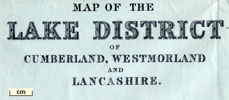
Map, on Pegamoid cloth, Map of The Lake District of
Cumberland, Westmorland and Lancashire, scale about 4 miles
to 1 inch, by/for A W Rumney, published by George Philip and
Son, 32 Fleet Street, London, and Liverpool, 1899.
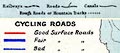
The uncoloured, except the blue sea and lakes, base map is overprinted with cycling roads coloured to indicate their surface quality. The map is printed on Pegamoid cloth, advertsied as untearable, impervious to water, etc. |
||
| map feature:- | table of symbols (two - one presumably of the original base map, the other for the overprinting) & up is N & scale line & lat and long scales & sea tinted & coast line & rivers & lakes & relief & hill hachuring & forests & parks & county & settlements & roads & railways & canals | |
| inscription:- |
printed lower left
MAP OF THE / LAKE DISTRICT / OF / CUMBERLAND, WESTMORLAND / AND / LANCASHIRE. |
|
| wxh, folded:- | 10x13cm | |
| wxh, sheet:- | 38x46.5cm | |
| wxh, map:- | 333x412mm | |
| inscription:- |
printed above scale line
English Miles. |
|
| scale line:- | 10 miles = 62.0 mm | |
| scale:- | 1 to 260000 ? (1 to 259572 from scale line) | |

|
||
|
||
| sources:- |
JandMN Collection |
|
| items seen (illustrated items in bold):- | ||

|
JandMN (147_1) -- road map -- Map of The Lake District of Cumberland, Westmorland and Lancashire | |