 Dumfries and Gretna

|

|
|
|
map type:- OS 1950s Seventh Series |
|
|
|
Map series, One Inch 7th Series maps of Great Britain,
scale 1 inch to 1 mile, published by the Ordnance Survey,
Southampton, Hampshire, from about 1952 to 1972.
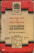
The maps were produced in ten colours 1952-61, in 6 colours 1961-72, also in outline editions etc. The series was continuously updated over the 20 years of publication. The sheets that concern Westmorland, Cumberland, and the parts of Lancashire north of the sands, and of Yorkshire, that became Cumbria are:- sheet 75 - Dumfries and Gretna sheet 76 - Carlisle sheet 77 - Hexham (just a tiny piece of Cumberland) sheet 82 - Keswick sheet 83 - Penrith sheet 84 - Teesdale sheet 88 - Barrow in Furness sheet 89 - Lancaster and Kendal sheet 90 - Wensleydale |
||
|
||
|
||
| references:- |
Hellyer, Roger: 1999: Ordnance Survey Small Scale Maps:
Archer, David (Kerry, Montgomeryshire):: ISBN 0 9517579 5
4 |
|
| sources:- |
JandMN Collection |
|
| sources:- |
|
|
| items seen (illustrated items in bold):- | ||
| see:- | JandMN (414) -- map series -- OS One Inch Seventh Series -- OS One Inch 7th end | |

|
JandMN (414_75) -- cover location map -- Dumfries and Gretna | |
|
|
JandMN (414_76) -- cover location map -- Carlisle | |
|
|
JandMN (414_77) -- cover location map -- Hexham | |
|
|
JandMN (414_82) -- cover location map -- Keswick | |
|
|
JandMN (414_83) -- cover location map -- Penrith | |
|
|
JandMN (414_84) -- cover location map -- Teesdale | |
|
|
JandMN (414_88) -- cover location map -- Barrow in Furness | |
|
|
JandMN (414_89) -- cover location map -- Lancaster and Kendal | |
|
|
JandMN (414_90) -- cover location map -- Wensleydale | |