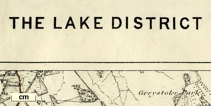
 Lake District

|

|
|
|
map type:- OS 1900 |
|
|
|
Map, The Lake District, scale 1 mile to 1 inch, published
by the Ordnance Survey, Southampton, Hampshire, 1900.
The map uses parts of existing One Inch map sheets 23, 24, 29, 30, 38, 39, 48, and 49, revised to 1896. |
||
|
(map example JandMN (134))
|
||
| map feature:- | folded (6x7) & card covers & index map & table of symbols & up is N & scale line & lat and long scales & rivers & bridges & relief & contours & spot heights & woods & trees & forests & county & settlements & roads & railways & canals | |
| inscription:- |
printed cover
ORDNANCE SURVEY. / THE LAKE DISTRICT. / PARTS OF SHEETS 23, 24, 29, 30, 38, 39, 48, 49. / SCALE ONE ONCH TO A MILE. / PRICE ONE SHILLING & SIXPENCE. black on red; royal coat of arms |
|
| inscription:- |
printed top, left, centre and right
ORDNANCE SURVEY OF ENGLAND / THE LAKE DISTRICT / PARTS OF SHEETS 23, 24, 29, 30, 38, 39, 48, 49 |
|
| inscription:- |
printed bottom
The Altitudes are given in Feet above the assumed Mean Sea Level at Liverpool, which is 0.650 of a Foot below the general Mean Level of the Sea ... |
|
| map, sheet:- | 65x86.5cm | |
| wxh, map:- | 567x766mm | |
| inscription:- |
printed above scale line
Scale of One Inch to One Statute Mile - 1/63360 |
|
| scale line:- | 4+1 miles = 127.4 mm | |
| scale:- | 1 to 63360 ? (nominal) | |

|
||
|
||
| sources:- |
JandMN Collection |
|
| items seen (illustrated items in bold):- | ||

|
JandMN (134) -- map -- Lake District | |