 Moll 1718

|

|
|
|
map type:- Moll 1718 |
|
|
|
Road strip maps for a road book, an abandoned project? by
Herman Moll, about 1718.
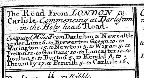
11 sheets are known with a general map of the south part of England and Wales, scale about 33 miles to 1 inch. These include one route in Cumbria. (The sheet number used below are allocated for convenience, they are not original.) sheet 7 scrolls 1 and 2 - London to Carlisle, scale roughly 8 miles to 1 inch - from the south through Lancaster and Carnforth, Lancashire; then through Burton, Kendal, Thrimby, Westmorland; Penrith to Carlisle, Cumberland. |
||
|
(example map)
|
||
| map feature:- | plain cartouche & compass rose & up is destination & rivers & relief & hillocks & county & settlements & roads & road distances | |
| inscription:- |
The Road from LONDON to / Carlisle, commencing at Darleston / in the Holy head Road. / Computed Miles / ... Lancaster ... to / Boulton 3. to Burton 5. to Kendal 8. to / Thrumby 17. to Penrith 5. to Carlisle 16. |
|
| sources:- |
David Webb Collection |
|
| items seen (illustrated items in bold):- | ||

|
private collection (134) -- strip map -- Road from London to Carlisle -- Road from London to Darby -- Road from London to Shrewsbury and Welshpool -- Road from London to St Neots and Oakeham | |