 Moll 1718

|

|
|
|
item:- private collection (134) image:- © see bottom of page |
click to enlarge |
|
|
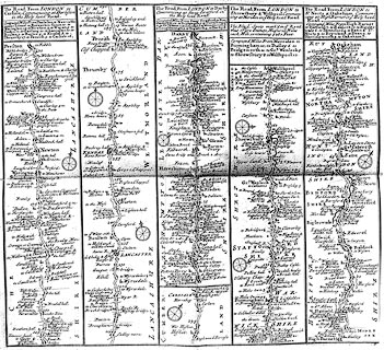
Strip map, photocopy, The Road from London to Carlisle,
The Road from London to Darby, The Road from London to
Shrewsbury and Welshpool, and The Road from London to St
Neots and Oakeham, by Herman Moll, 1718.
The route includes from Lancaster through Carnforth, Lancashire; then Burton, Kendal, Westmorland; Penrith to Carlisle, Cumberland; note that Shap does not appear. (This map is rare; a photocopy is all that has been available to illustrate it, as yet.) |
||

|
Moll 1718 | |
| map feature:- | plain cartouche & compass rose & up is destination & rivers & relief & hillocks (ascents, inverted for descents) & parks & county & settlements & roads & road distances & table of distances | |
| inscription:- |
printed title cartouche at head of strip map
The Road from LONDON to / Carlisle. Commencing at Darleston / in the Holy head Road. / Computed Miles from Darleston to Newcastle / under Lime 6. to Brewerton Green 10. to / Warrington 15. to Newton 3. to Wigan 5. to / Preston 12. to Garstang 10. to Lancaster 10. to / Boulton 3. to Burton 5. to Kendal 8. to / Thrumby 17. to Penrith 5. to Carlisle 16. |
|
| inscription:- |
printed title cartouche at top of strip
The Road from LONDON to Darby / Commencing at Stony Stratford in / the Holy head Road. / ... |
|
| inscription:- |
printed title cartouche at top of strip
The Road from LONDON to / Shrewsbury & Welshpool. Commen= / cing at Meriden in ye Holy head Road. |
|
| inscription:- |
printed title cartouche at top of strip
The Road from LONDON to / St. Neots & Oakeham. Commen= / cing at High Barnet in ye Holy head / Road. |
|