 Sketch of the Excursion between London and
Inverary
Sketch of the Excursion between London and
Inverary

|

|
|
|
map type:- Mawman 1805 map |
|
|
|
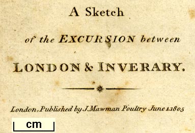
Map, Sketch of the Excursion between London and Inverary,
scale about 23 miles to 1 inch, engraved by J Bye, published
by Joseph Mawman, Poultry, London, 1805.
Frontispiece to a tour, An Excursion to the Highlands of Scotland and the English Lakes, by Joseph Mawman. |
||
|
(example Armitt Library : A978.1)
|
||
| map feature:- | folded (1x3; damaging) & compass rose & up is NW (NNW) & scale line & sea plain & coast shaded & rivers & lakes & relief & hillocks (in ranges) & county & settlements (for the tour) & roads (for the tour) | |
| inscription:- |
printed lower left
A Sketch / of the EXCURSION between / LONDON & INVERARY. / London, Published by J. Mawman Poultry June 1. 1805 |
|
| inscription:- |
printed bottom
J. Bye Sculp. |
|
| wxh, sheet:- | 12.5x43cm | |
| wxh, map:- | 111x398mm | |
| inscription:- |
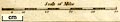
printed with scale line
Scale of Miles |
|
| scale line:- | 50 miles = 56.2 mm | |
| scale:- | 1 to 1400000 ? (1 to 1431801 from scale line assuming a statute mile) | |
|
||
| sources:- |
Armitt Library Bicknell 1990 |
|
| items seen (illustrated items in bold):- | ||

|
Armitt Library : A978.1 -- map -- Sketch of the Excursion between London and Inverary | |