 Physical Map of Westmorland

|

|
|
|
map type:- Marr 1909-12 map |
|
|
|
Maps, physical and geological maps of Westmorland,
Cumberland, North Lancashire, scale about 7-10 miles to 1
inch, by George Philip and Son, The London Geographical
Institute, Published by Cambridge University Press,
Cambridge, Cambridgeshire, 1909.
Printed on the front and back endpapers of the corresponding county volume in the Cambridge County Geographies Series, by J E Marr. The volumes have other maps in their text. |
||
|
(map example JandMN (75_1))
|
||
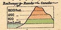
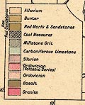
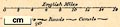
| map feature:- | up is N & scale line & lat and long scales & table of symbols & sea tinted & coast line & rivers & lakes & relief & contours & layer colouring & hill hachuring & county & settlements & roads & railways & canals | |
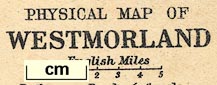
| inscription:- |
printed lower right
PHYSICAL MAP OF / WESTMORLAND |
|
| inscription:- |
printed bottom left and right
George Philip & Son, Ltd. / The London Geographical Institute |
|
| wxh, map:- | 203x152mm (excluding a gap) | |
| scale line:- | 5 miles = 18.4 mm | |
| scale:- | 1 to 430000 ? (1 to 437322 from scale line) | |
|
||
|
||
|
||
|
||
| sources:- |
JandMN Collection |
|
| items seen (illustrated items in bold):- | ||

|
JandMN (75_1) -- map -- Physical Map of Westmorland | |
|
|
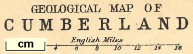
JandMN (75_2) -- map -- Geological Map of Westmorland | |
|
|
JandMN (75_4) -- map -- Roman Roads of Westmorland | |
|
|
JandMN (76_1) -- map -- Physical Map of Cumberland | |
|
|
JandMN (76_2) -- map -- Geological Map of Cumberland | |
|
|
JandMN (77_1) -- map -- Physical Map of Lancashire, North Sheet | |
|
|
JandMN (77_2) -- map -- Geological Map of Lancashire, North Sheet | |