 Marr 1909-12 map

|

|
|
|
item:- JandMN (77_1) image:- © see bottom of page |
click to enlarge |
|
|
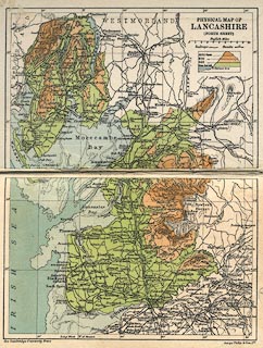
Map, colour lithograph? Physical Map of Lancashire, North
Sheet, scale about 6.5 miles to 1 inch, by George Philip and
Son, The London Geographical Institute, Published by
Cambridge University Press, Cambridge, Cambridgeshire, 1912.
On the front endpapers of North Lancashire in the Cambridge County Geographies Series, by J E Marr. |
||

|
Marr 1909-12 map | |
| map feature:- | up is N & scale line & lat and long scales & table of symbols & sea tinted & coast line & rivers & lakes & relief & contours & layer colouring & hill hachuring & county & settlements & roads & railways & canals | |
| inscription:- |
printed upper right
PHYSICAL MAP OF / LANCASHIRE / (NORTH SHEET) |
|
| inscription:- |
printed bottom left and right
George Philip & Son, Ltd. / The London Geographical Institute |
|
| scale line:- | 10 miles = 39.0 mm | |
| wxh, map:- | 160x204 (excluding a gap) | |
| scale:- | 1 to 410000 ? (1 to 412652 from scale line) | |