 Correct Map of the Road from London to Carlisle

|

|
|
|
map type:- Gibson 1766 |
|
|
|
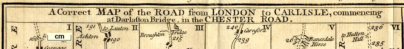
Road strip map, 2 roads, The Correct Map of the Road from
London to Carlisle, and The Road from Carlisle to Berwick,
about 2 miles to 1 inch? drawn and engraved by J Gibson,
published in the Gentleman's Magazine, 1766.
The first part is from Darlaston Bridge, Staffordshire; through Holmes Chapel, Cheshire; Warrington, Wigan, Preston, Lancaster, Carnforth, Lancashire; crossing the county boundary near the Birk Stone, then Burton, Sidgwick, Kendal, Shap, Eamont Bridge, Westmorland; and Penrith to Carlisle, Cumberland. The second part is from Carlisle, Cumberland; cross the border at the Kirsop River near Kirkby Hill, through Jedborough, Kelso, Scotland; to Berwick, Northumberland. Published with the Gentleman's Magazine, vol.36 issue for October 1766, bound in opposite p.446 (in the volume seen). The preface to this volume has a:- 'Direction for placing the COPPER-PLATES in Volume XXXVI. ... OCTOBER. A Map of the Roads from London to Carlisle ... DECEMBER. A Map of the Roads from London to Flamborough-head, &c. being the eleventh in the Series, which eleven Maps may be laid by, and when the whole Set is compleated, a new Description will be printed separately, and sold at a small price for the use of Travellers.' Vol.35 for 1765 has 5 maps; vol.36 for 1766 has 6; a further map has been found in vol.39 for 1769; but I have not traced any others. |
||
|
(example map Dove Cottage : 2007.38.3)
|
||
| map feature:- | title cartouche & plain cartouche & up is destination & rivers & relief & hillocks & parks & county & settlements & roads & road distances & distances from London | |
| inscription:- |
printed top right
Gent : Mag : |
|
| inscription:- |
printed title cartouche, top
A Correct MAP of the ROAD from LONDON to CARLISLE, commencing / at Darlaston Bridge, in the CHESTER ROAD. / The ROAD from CARLISLE to BERWICK. |
|
| inscription:- |
printed bottom right
Drawn & Engraved by J. Gibson. |
|
| inscription:- |
water mark:
PRO PATRIA ... lion, ring of fence palings for a park, etc? |
|
| wxh, sheet:- | 31x20.5cm | |
| wxh, map:- | 287x173mm | |
| scale:- | 1 to 240000 ? (estimated from road distances) | |
| sources:- |
Armitt Library Wordsworth Trust Collection |
|
| items seen (illustrated items in bold):- | ||

|
Armitt Library : Gents Mag 1766.1 -- strip map -- Correct Map of the Road from London to Carlisle -- Road from Carlisle to Berwick | |
|
|
Dove Cottage : 2007.38.3 -- strip map -- Correct Map of the Road from London to Carlisle -- Road from Carlisle to Berwick | |