 Inglis' New Graded Maps

|

|
|
|
map type:- Gall and Inglis 1900s |
|
|
|
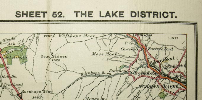
Road maps, Inglis' New Graded Maps series, including
sheet 52, The Lake District, scale about 2 miles to 1 inch,
published by Gall and Inglis, 12 Newington Road, Edinburgh,
about 1900.
The roads are coloured for their quality, and over printed triangle symbols show the steep gradients. The map series hasf 71 sheets in England, Wales and Scotland; the maps that concern Cumbria are:- sheet 47 includes north parts of Lancashire; sheet 48 the east edge of Westmorland, and part of West Yorkshire; sheet 52 most of The Lakes in Westmorland and Cumberland; sheet 53 east parts of Westmorland, and part of North Yorkshire; sheet 57 north parts of Cumberland, and part of Scotland; sheet 58 east parts of Cumberland, and parts of Durham and Northumberland. |
||
|
(example Kendal Library : Map 156)
|
||
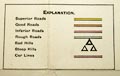
| map feature:- | folded (9x4 or 7 2/2 x 3 1/2 pieces) & table of symbols & up is N & scale line & sea plain & coast line & coast tinted & rivers & lakes & relief & spot heights & woods & forests & county & settlements & roads & road gradients & railways | |
| inscription:- |
printed top left, right
INGLIS' NEW 'GRADED' MAPS / SHEET 52. THE LAKE DISTTRICT. |
|
| inscription:- |
printed bottom right
Gall & Inglis, Edinburgh. |
|
| inscription:- |
printed bottom left
PUBLISHED BY GALL AND INGLIS, 12 NEWINGTON ROAD, EDINBURGH : & LONDON. |
|
| inscription:- |
printed end cover
The / GRADED / ROAD MAPS / of / England / Scale, half an inch to a Mile / The Lake District / ... |
|
| wxh, sheet:- | 75.5x63.5cm | |
| wxh, map:- | 730x605mm | |
| inscription:- |
printed with scale line
SCALE HALF AN INCH TO A MILE = 1/126270 = 3 1/4 KILOMETRES TO AN INCH |
|
| scale line:- | 14 miles = 177.1 mm | |
| 1 to 130000 ? (1 to 127220 from scale line):- | ||

|
||
|
||
| sources:- |
|
|
| items seen (illustrated items in bold):- | ||

|
Kendal Library : Map 156 -- map -- Lake District -- Inglis' New Graded Maps | |