 Gall and Inglis 1900s

|

|
|
|
item:- Kendal Library : Map 156 image:- © see bottom of page |
click to enlarge |
|
|
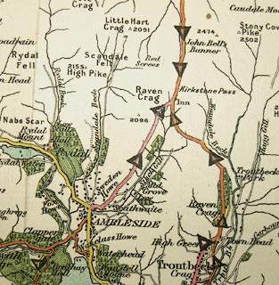
Map, colour lithograph, Inglis' New Graded Maps series,
sheet 52, The Lake District, scale about 2 miles to 1 inch,
published by Gall and Inglis, 12 Newington Road, Edinburgh,
about 1900.
The roads are coloured for their quality, and over printed triangle symbols show the steep gradients. Notice that there is no surfaced road over Wrynose and Hardknott passes. |
||

|
Gall and Inglis 1900s | |
| map feature:- | folded (9x4 or 7 2/2 x 3 1/2 pieces) & table of symbols & up is N & scale line & sea plain & coast line & coast tinted & rivers & lakes & relief & spot heights & woods & forests & county & settlements & roads & road gradients & railways | |
| inscription:- |
printed top left, right
INGLIS' NEW 'GRADED' MAPS / SHEET 52. THE LAKE DISTTRICT. |
|
| inscription:- |
printed bottom right
Gall & Inglis, Edinburgh. |
|
| inscription:- |
printed bottom left
PUBLISHED BY GALL AND INGLIS, 12 NEWINGTON ROAD, EDINBURGH : & LONDON. |
|
| inscription:- |
printed end cover
The / GRADED / ROAD MAPS / of / England / Scale, half an inch to a Mile / The Lake District / ... |
|
| inscription:- |
printed with scale line
SCALE HALF AN INCH TO A MILE = 1/126270 = 3 1/4 KILOMETRES TO AN INCH |
|
| scale line:- | 14 miles = 177.1 mm | |
| wxh, sheet:- | 75.5x63.5cm | |
| wxh, map:- | 730x605mm | |
| 1 to 130000 ? (1 to 127220 from scale line):- | ||