 CTC 1899 map

|

|
|
|
map type:- CTC 1899 map |
|
|
|
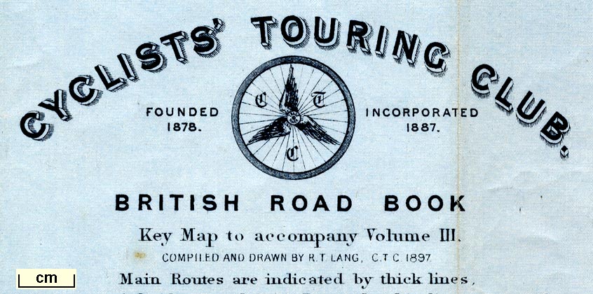
Index map to accompany Cyclists' Touring Club British
Road Book, vol.3, Northen Counties, scale about 8.5 miles to
1 inch, drawn by R T Lang, 1897, published by E R Shipton,
47 Victoria Street, Westminster, London etc, 1899.
Folded in a pocket of the CTC British Road Book, vol.3, 3rd edn 1899. The map shows Northumberland, Durham, Cumberland, Westmorland, Yorkshire, Lancashire, parts of adjacent counties, and the Isle of Man. |
||
| see:- | CTC 1899 | |
|
(example JandMN (492))
|
||
| map feature:- | folded (6x4) & table of symbols & up is N & scale line & sea tinted & coast line & rivers & lakes & settlements & roads & inset map (Isle of Man) | |
| inscription:- |
printed upper right
CYCLISTS' TOURING CLUB. / FOUNDED 1878. [CTC badge] INCORPORATED 1887. / BRITISH ROAD BOOK / Key Map to accompany Voume III. / COMPILED AND DRAWN BY R. T. LANG, C.T.C. 1897 / ... |
|
| inscription:- |
printed bottom left, right, centre
Copyright, Entered at Stationers Hall / Stanford's Geographical Establishment, London. / Published for the "Cyclists' Touring Club" by E. R. Shipton, Secretary & Editor of the "C.T.C. Gazette", Chief Offices, 47, Victoria Str., Westminster, S.W. |
|
| wxh, sheet:- | 51x58.5cm | |
| wxh, map:- | 465x543mm | |
| inscription:- |
printed with scale line
Scale of Miles |
|
| scale line:- | 40+10 miles = 148.8 mm | |
| scale:- | 1 to 540000 ? (1 to 540774 from scale line) | |

|
||
|
||
| sources:- |
JandMN Collection |
|
| items seen (illustrated items in bold):- | ||

|
JandMN (492_1) -- road map | |