 Westmorland

|

|
|
|
map type:- Census 1901 map |

|
|
|
Maps, Westmorland, Cumberland, and Lancashire, to
illustrate extracts from the Census 1901, scale about 4
miles to 1 inch, printed by the Ordnance Survey,
Southampton, Hampshire, published by HMSO, London, 1902.
|
||
|
(example Kendal Library (35_3))
|
||
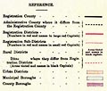
| map feature:- | folded (3x2; torn and crumpled) & table of symbols & up is N & scale line & rivers (a few) & coast line & county & registration districts (census, and sub districts) | |
| inscription:- |
printed upper centre
WESTMORLAND. |
|
| inscription:- |
printed lower right
Printed at the Ordnance Survey Office, Southampton, 1902. |
|
| wxh, sheet:- | 50x42.5cm | |
| scale 1 to 250000 ?:- | ||
| inscription:- |
printed with scale line
Scale Four Miles to One Inch |
|
| scale line:- | 12+2 miles = 88 mm (about) | |

|
||
|
||
| sources:- |
Kendal Library |
|
| items seen (illustrated items in bold):- | ||

|
Kendal Library (35_1) -- map -- Lancashire | |
|
|
Kendal Library (35_2) -- map -- Cumberland | |
|
|
Kendal Library (35_3) -- map -- Westmorland | |