 Platt of the Opposete Borders of Scotland to ye West Marches
of England
Platt of the Opposete Borders of Scotland to ye West Marches
of England

|

|
|
|
map type:- Burghley 1590 |
|
|
|
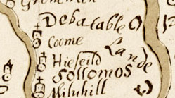
Map, ms ink on parchment, A Platt of the Opposete Borders
of Scotland to ye West Marches of England, scale about 2.5
miles to 1 inch, drawn for Lord Burghley, 1590.
The map comes from an atlas used to illustrate domestic matters, that belonged to William Cecil Lord Burghley, Secretary of State to Elizabeth I. It shows the Debatable Lands, an area claimed by neither England nor Scotland; a lawless noman~s land. Lord Burghley has annotated the map, adding place names at points along the river which forms part of the border, and the river immediately to the right of this which lies in English. |
||
|
(British Library : Royal MS 18 D.III f.76)
|
||
| inscription:- |
ms reverse
A Platt of the opposete Borders of Scotland to ye west marches of England / Dec. 1590 |
|
| wxh:- | 40x29.5cm | |
| items seen (illustrated items in bold, * have map squares etc):- | ||

|
British Library : Royal MS 18 D.III f.76 -- map -- Platt of the Opposete Borders of Scotland to ye West Marches of England | |
|
|
National Library of Scotland : MS6113 f.267 -- map (facsimile) -- Platt of the Opposete Border of Scotland to ye West Marches of England * | |