 Burghley 1590

|

|
|
|
item:- National Library of Scotland : MS6113 f.267 image:- © National Library of Scotland |
click to enlarge |
|

|
menu with map squares and placename index | |
|
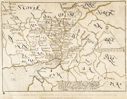
Facsimile map, A Platt of the Opposete Border of Scotland
to ye West Marches of England, parts of Cumberland and
Scotland including the Debatable Land, from a manuscript
drawn for William Cecil, Lord Burghley, about 1590,
published by R B Armstrong, 1897.
The names Johnston, Kyrkandor, Brackenhill, and Rosetere along the border are added in the handwriting of Lord Burghley. The original ms is in the British Library, item Royal MS 18 D.III f.76. Images of the map courtesy of the Trustees of the National Library of Scotland. |
||
|
|
Burghley 1590 | |
| map feature:- | up is N & scale line & sea stippled & coast line & rivers & bridges & county & settlements | |
|
|
||
|
|
notes | |