 Bowen 1762

|

|
|
|
map type:- Bowen 1762 |
|
|
|
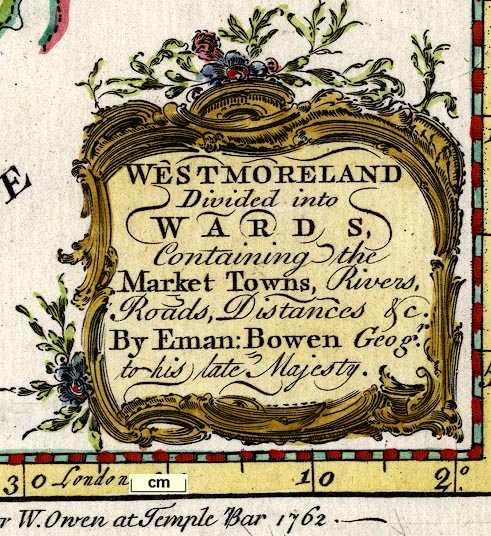
Maps, Westmoreland, scale about 10 miles to 1 inch, and
Cumberland, scale about 11 miles to 1 inch, by Emanuel
Bowen, 1762, published by W Owen, Homer's Head, Fleet
Street, London, 1762 in a monthly series of county maps;
published 1762-63.
Published in 'The General Magazine Of Arts and Sciences, Philosophical, Philological, Mathematical, and Mechanical ... By Benjamin Martin. London. Printed for W. Owen, at Homer's Head, in Fleet-street. ...' about 1762? Published in 'The Natural History Of England; ... Illustrated by a Map of each County. Vol.II. Containing [list 0f 36 counties] By Benjamin Martin. ... MDCCLXIII.' ie 1763. Volume I was 'The Natural History Of England; Or, A Description of each particular County, In regard to the Curious Productions of Nature and Art. Illustrated by a Map of each County, and Sculptures of Natural Curiosities. Vol.I. Containing [list of 14 counties] By Benjamin Martin. London: Printed and sold by W. Owen, Temple-Bar, and by the Author, at his House in Fleet-street, MD CC LIX.' ie 1759. |
||
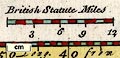
| scale line:- | 12 miles = 31 mm | |
| scale:- | 1 to 620000 ? (1 to 622972 from scale line assuming modern mile) | |
| scale line:- | 15 miles = 1 3/8 ins | |
| scale:- | 1 to 690000 ? | |
|
||
|
||
| references:- |
Martin, Benjamin: 1765: General Magazine of Arts and
Sciences: Owen, W (London) Martin, Benjamin: 1759: Natural History of England : Owen, W (London) |
|
| sources:- |
Chubb 1927 (CCXV) Hodson 1984 Armitt Library Kendal Library Maps Carlisle Library Maps |
|
| items seen (illustrated items in bold):- | ||

|
Armitt Library : ALMC2008.14.113 -- map -- Westmoreland | |
|
|
Armitt Library : ALMC2008.14.114 -- map -- Westmoreland | |
|
|
Carlisle Library : Map 8 -- map -- Cumberland | |
|
|
Kendal Library : Map 29 -- map -- Westmoreland | |
|
|
Kendal Library : Map 45 -- map -- Westmoreland | |