 Bowen 1762

|

|
|
|
item:- Armitt Library : ALMC2008.14.114 image:- © see bottom of page |
click to enlarge |
|
|
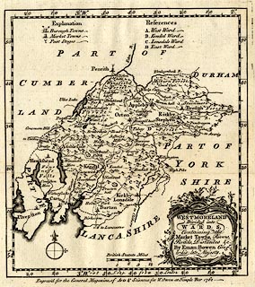
Map, uncoloured engraving, Westmoreland, scale about 10
miles to 1 inch, by Emanuel Bowen, 1762, published by W
Owen, Temple Bar, London, 1763.
For the General Magazine of Arts and Sciences, and included in The Natural History of England by Benjamin Martin; the map was zigzag folded to fit in the book. Descriptive text headed 'The NATURAL HISTORY of WESTMORELAND', pp.313-317, accompanies the map. |
||

|
Bowen 1762 | |
| map feature:- | baroque cartouche & table of symbols & compass rose & up is N & scale line & lat and long scales (rectangular projection, W from London) & sea plain & coast shaded & rivers & lakes & relief & hillocks & woods & forests & parks & county & wards & table of wards & settlements & roads & road distances & post roads | |
| inscription:- |
printed title cartouche, lower right
WESTMORELAND / Divided into / WARDS, / Containing the / Market Towns, Rivers, / Roads, Distances, &c. / By Eman : Bowen Geogr. / to his late Majesty. |
|
| inscription:- |
printed bottom
Engrav'd for the General Magazine of Arts & Sciences; for W. Owen at Temple Bar 1762. |
|
| inscription:- |
printed above scale line
British Statute Miles |
|
| scale line:- | 12 miles = 31.2 mm | |
| longitude, Kendal:- | 2d 51m W | |
| wxh, sheet:- | 20.5x26.5cm | |
| wxh, map:- | 172x192mm | |
| wxh, page:- | 12.5x20.5 | |
| scale:- | 1 to 620000 ? (1 to 618978 from scale line) | |