 Map of the English Lakes

|

|
|
|
map type:- Barber 1873 map |
|
|
|
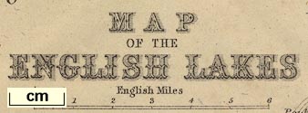
Map of the English Lakes, parts of Lancashire, Cumberland
and Westmorland, now Cumbria, scale about 3.5 miles to 1
inch, published by The Graphotyping Co, 7 Garrick Street and
Simpkin, Marshall and Co, Stationers' Hall Court, London,
and by J Atkinson, King Street, Ulverston, Cumberland, about
1873.
Tipped in, folded, opposite the title page in The Tourist's Picturesque Guide to Furness Abbey, the Vicinity, and Lakes Coniston and Windermere, by Henry Barber. |
||
|
(map example JandMN (69_1))
|
||
| map feature:- | up is N & scale line & sea tinted & coast form lines & rivers & lakes & relief & hill hachuring & county & settlements & roads & railways & canals | |
| inscription:- |
printed lower centre
MAP / OF THE / ENGLISH LAKES |
|
| wxh, sheet:- | 20.5x32cm | |
| wxh, map:- | 190x303mm | |
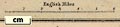
| scale line:- | 6 miles = 43.8 mm | |
| scale:- | 1 to 220000 ? (1 to 220458 from scale line) | |
|
||
| sources:- |
JandMN Collection |
|
| items seen (illustrated items in bold):- | ||

|
JandMN (69_1) -- map -- Map of the English Lakes | |