 Map of the Lake District

|

|
|
|
map type:- Atkinson 1847 map |
|
|
|
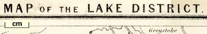
Map of the Lake District, scale about 4 miles to 1 inch,
by Thomas Hill, perhaps engraved by W H LIzars, published by
Thomas Atkinson, Kendal, Westmorland, 1847-53.
Included in a Handbook to the English Lakes. |
||
|
(example Armitt Library : A1144.2)
|
||
| map feature:- | folded (3x2) & north point & up is N & scale line & sea plain & coast form lines & rivers & lakes & relief & hill hachuring & parks & settlements & roads & railways | |
| inscription:- |
printed top
MAP OF THE LAKE DISTRICT |
|
| inscription:- |
printed bottom left, right, centre
Thomas Hill delt. / W H [Lizars ] Sculpt. / Published by Thos. Atkinson, Kendal. |
|
| wxh, sheet:- | 20x29.5cmcm | |
| wxh, map:- | 186x264mm | |
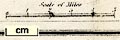
| inscription:- |
printed with scale line
Scale of Miles |
|
| scale line:- | 5 miles = 33.7 mm | |
| scale:- | 1 to 240000 ? (1 to 238775 from scale line) | |
|
||
| items seen (illustrated items in bold):- | ||

|
Armitt Library : A1144.2 -- map -- Map of the Lake District | |