 Arthur's Plan of Carlisle

|

|
|
|
map type:- Arthur 1880 |
|
|
|
Town plan, Arthur's Plan of Carlisle, scale about 12.5
ins to 1 mile, published by A B Moss, 73 English Street,
Carlisle, Cumberland, 1880.
|
||
|
(example map Carlisle Library (69))
|
||
| map feature:- | compass rose & up is N & scale line & rivers & bridges & settlements & roads & railways & electoral data (city and ward boundaries) & streets | |
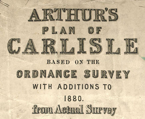
| inscription:- |
printed lower left
ARTHUR'S / PLAN OF / CARLISLE / BASED ON THE / ORDNANCE SURVEY / WITH ADDITIONS TO / 1880 / from Actual Survey |
|
| inscription:- |
printed bottom left
THIS MAP IS COPYRIGHT OF A. B. MOSS, 73 ENGLISH STREET, CARLISLE, AND IS ENTERED AT STATIONERS HALL, JUNE, 1880. |
|
| inscription:- |
printed with scale lines
SCALES / (12 1/2 Inches = 1 Mile.) |
|
| wxh, sheet:- | 99.5x69cm | |
| wxh, map:- | 977x646mm | |
| scale line:- | 2000 feet = 121.1 mm | |
| scale line:- | 40 chains = 159.1 mm | |
| scale:- | 1 to 5000 ? (1 to 5046 from scale lines) | |
| sources:- |
Carlisle Library Maps |
|
| items seen (illustrated items in bold):- | ||

|
Carlisle Library : Map 51 -- street map -- Arthur's Plan of Carlisle | |
|
|
Carlisle Library : Map 52 -- street map -- Arthur's Plan of Carlisle | |