 Arthur 1880

|

|
|
|
item:- Carlisle Library : Map 51 image:- © Carlisle Library |
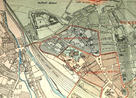
click to enlarge | |
| Illustration of part of map only. | ||
|
Town plan, colour lithograph, Arthur's Plan of Carlisle,
scale about 12.5 ins to 1 mile, published by A B Moss, 73
English Street, Carlisle, Cumberland, 1880.
The map shows the following railways in their complicated layouts in and around the city: North Eastern Railway, Midland Railway, London and North Western Raiway, Maryport and Carlisle Railway, Caledonian Railway, North British Railway, Silloth and Port Carlisle Railway. |
||

|
Arthur 1880 | |
| map feature:- | compass rose & up is N & scale line & rivers & bridges & settlements & roads & railways & electoral data (city and ward boundaries) | |
| inscription:- |
printed lower left
ARTHUR'S / PLAN OF / CARLISLE / BASED ON THE / ORDNANCE SURVEY / WITH ADDITIONS TO / 1880 / from Actual Survey |
|
| inscription:- |
printed bottom left
THIS MAP IS COPYRIGHT OF A. B. MOSS, 73 ENGLISH STREET, CARLISLE, AND IS ENTERED AT STATIONERS HALL, JUNE, 1880. |
|
| inscription:- |
printed with scale lines
SCALES / (12 1/2 Inches = 1 Mile.) |
|
| scale line:- | 2000 feet = 121.1 mm | |
| scale line:- | 40 chains = 159.1 mm | |
| wxh, sheet:- | 99.5x69cm | |
| wxh, map:- | 977x646mm | |
| scale:- | 1 to 5000 ? (1 to 5046 from scale lines) | |