 Diocese of Carliol

|

|
|
|
map type:- Arrowsmith 1825 |
|
|
|
Maps, Diocese of Carliol with the Diocese of Dunolm,
Carlisle and Durham, and Dioces of Cestr, Chester, in the
time of Henry VIII, 1535, scale about 6 miles to 1 inch, by
Aaron Arrowsmith, London, 1825.
Included in vol.5 of Valor Ecclesiasticus temp. Henr. VIII Auctoritate Regia Institutus, editor J Caley, indexer J Hunter, published by the Commissioners on the Public Records of the Kingdom, London, 1825. This volume also includes the diocesan map for York which intesects with modern Cumbria. The 6 volumes were published from 1810-34. |
||
|
(example JandMN (349))
|
||
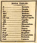
| map feature:- | table of symbols (abbreviations of types of foundation) & up is N & lat and long scales (trapezoidal projection?) & lat and long grid (1x1 degree) & sea plain & coast shaded & rivers & lakes & settlements (only shows churches, religious houses, etc) | |
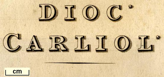
| inscription:- |
printed left
DIOC' / CARLIOL' |
|
| inscription:- |
printed left
DIOC' / DUNOLM' |
|
| inscription:- |
printed top
Tabula - Juxta Valorem Ecclesiasticum XXVo Henrici VIII Institutum - Geographica. |
|
| inscription:- |
printed bottom left, right
A. Arrowsmith Delin. / A.D. MDCCCXXV. |
|
| wxh, sheet:- | 46x47.5cm | |
| wxh, map:- | 437x452mm | |
| scale:- | 1 to 330000 ? (estimate) | |
|
||
| sources:- |
COPAC JandMN Collection University of York |
|
| items seen (illustrated items in bold):- | ||

|
JandMN (349) -- map -- Diocese of Carliol -- Diocese of Dunolm | |
|
|
University of York : C70.6/REC/map 2 -- map -- Diocese of Cestr | |