 Arrowsmith 1825

|

|
|
|
item:- JandMN (349) image:- © see bottom of page |
click to enlarge |
|
|
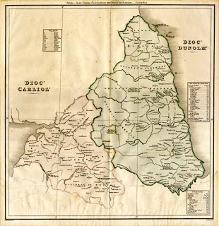
Map, coloured lithograph? Diocese of Carliol ie Carlisle,
and Diocese of Dunolm ie Durham, in the time of Henry VIII,
1535, scale about 6 miles to 1 inch, by Aaron Arrowsmith,
London, 1825.
Included in vol.5 of Valor Ecclesiasticus temp. Henr. VIII Auctoritate Regia Institutus, editor J Caley, indexer J Hunter, published by the Commissioners on the Public Records of the Kingdom, London, 1825. |
||

|
Arrowsmith 1825 | |
| map feature:- | table of symbols (abbreviations of types of fooundation) & up is N & lat and long scales (trapezoidal projection?) & lat and long grid (1x1 degree) & sea plain & coast shaded & rivers & lakes & settlements (only shows churches, religious houses, etc) | |
| inscription:- |
printed left
DIOC' / CARLIOL' |
|
| inscription:- |
printed left
DIOC' / DUNOLM' |
|
| inscription:- |
printed top
Tabula - Juxta Valorem Ecclesiasticum XXVo Henrici VIII Institutum - Geographica. |
|
| inscription:- |
printed bottom left, right
A. Arrowsmith Delin. / A.D. MDCCCXXV. |
|
| wxh, sheet:- | 46x47.5cm | |
| wxh, map:- | 437x452mm | |
| scale:- | 1 to 330000 ? (estimate) | |