 Amalgamated Press 1930s

|

|
|
|
map type:- Amalgamated Press 1930s |
|
|
|
Road map, set of 31 map cards plus a general index map,
presented with the New Motoring Encyclopedia, published by
the Amalgamated Press, Fleetway House, London, perhaps
1930s.
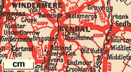
Card 21 has Westmorland, Cumberland and Lancashire North of the Sands and parts of surrounding counties, including southern Scotland. |
||
|
(map example Hampshire Museums : FA2003.96)
|
||
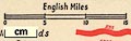
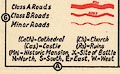
| map feature:- | index map & up is N & scale line & table of symbols & sea tinted & coast line & rivers & index grid & county & settlements & roads | |
| inscription:- |
printed bottom of reverse side of each card
The maps are based upon the Ordnance Survey with the sanction of the Controller of H.M. Stationery Office and printed by the Amalgamated Press, Ltd., The Fleetway House, London, E.C.4. |
|
| wxh, sheet:- | 20x27cm | |
|
||
|
||
| sources:- |
HMCMS Map Collection |
|
| items seen (illustrated items in bold):- | ||

|
Hampshire Museums : FA2003.96 -- road map | |