 Amalgamated Press 1930s

|

|
|
|
item:- Hampshire Museums : FA2003.96 image:- © see bottom of page |
click to enlarge |
|
|
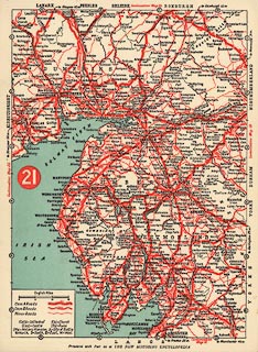
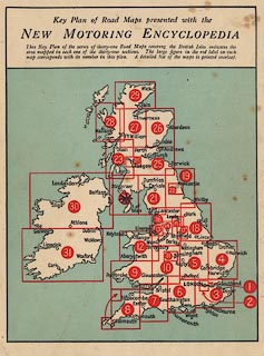
Road map, set of 31 map cards plus a general index map,
scale about 10 miles to 1 inch, presented with the New
Motoring Encyclopedia, published by the Amalgamated Press,
Fleetway House, London, perhaps 1930s.
Card 21 has Westmorland, Cumberland and Lancashire North of the Sands and parts of surrounding counties, including southern Scotland. |
||

|
Amalgamated Press 1930s | |
| map feature:- | index map & up is N & scale line & table of symbols & sea tinted & coast line & rivers & index grid & county & settlements & roads | |
| inscription:- |
printed bottom of reverse side of each card
The maps are based upon the Ordnance Survey with the sanction of the Controller of H.M. Stationery Office and printed by the Aamalgamated Press, Ltd., The Fleetway House, London, E.C.4. |
|
| inscription:- |
printed with scale line
English Miles |
|
| scale line:- | 15 miles = 37.6 mm | |
| wxh, sheet:- | 20x27cm | |
| scale:- | 1 to 640000 ? (1 to 642026 from scale line) | |
|
||