 Speed 1611

|

|
|

|
back to object record | |
| MAP FEATURES | ||
|
The map was printed as a black and white engraving and has
been hand coloured, I think fairly recently.
|
||
|
|
||
| picture frame border |
The border of the map is engraved to look like the carved wood of a picture frame. |
|
|
|
||
|
title cartouche
strapwork cartouche picture frame cartouche map maker publisher |
Printed upper left in a circular cartouche with a picture frame surround, and strapwork decoration is:- CUMBERLAND AND THE ANCIENT CITIE CARLILE DESCRIBED WITH MANY MEMORABLE ANTIQUITIES THEREIN FOUND OBSERVED printed lower right of centre is:- Performed by John Speed, and are to be sould in Popes. head Alley, by the exchange by J. Sudbury and Georg Humble. Cum Privilegio Anno Domini 1610. |
|
|
|
||
| coat of arms |
Printed above the title cartouche is the royal coat of
arms of the house of Stuart. The blazon below described how
the colourist has treated this coat of arms (and the
technical language might have a mistake or two!):-
quarterly 1 and 4 quarterly 1 and 4 azure three fleur de lys or 2 and 3 gules three lions passant guardant or 2 or a lion rampant gules in a double tressure flory counterflory or 3 azure a harp or This is the old royal arms quartering England and France, quartered with the arms of Scotland and of Ireland. This was introduced by James VI of Scotland who became James I of England, 1603, still a new event when this map was drawn. (The formal union of the two nations was not until 1707.) The supporters, a lion and unicorn, carry banners with a rose and a thistle respectively. Printed lower left with the scale line is the coat of arms of:- 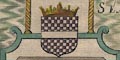
HENRY CLIFFORD Earle |
|
|
|
||
|
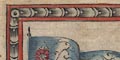
descriptive text
vignettes |
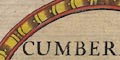
Printed lower right is a panel of text about
Cumberland:-
This countye being the uttermost Limits of the Romane Empyre, and defenced with that admirable wall as is above sayd, was continewally frequented with their Legions and Souldiers, whoe in tyme of peace, or after victoryes acheived, buylt many monuments and Altars, with inscriptions to their Idole Gods, for the prosperity of their Emperours and themselves, many of them yet remayning in divers places there, are to be sene, and some of them according to their trues formes here expressed, as they have bene, most carefull and exactly taken by men of worthy note and credite. In spare space on the map sheet, left and right, are engravings of roman altars, with inscriptions:- GENIO LOCI FORTUNAERE DUCI ROMAE AETERNAE ET FATO BONO G. CORNELIUS PEREGRINUS TRIB. COHORT EXPROVINCIA MAUR. CAES. DOMOSTEDS DECUR. BELATU CADRO I.V.L.CL VILIS OPT V.S.L.M I:O:M ALA AUG. OB VIRTUTEM A[ ]ATA. CUI. PRAE EST PAEL PUB[ ] SERGIA MAGNUS / MURSA EX [ ]N NON INFERIOR RAE FEC A RONINO EBRO DIS DEABUSQ P. POSTHUMUS A CILIANUS PRAE COH LDELM VOLANTII VIVAS A different sort of illustration is engraved above the county text, lower centre. Two tight formations of soldiers carrying spears, shields, tinted red and blue, appear to be in battle. A symbol like this is used by John Speed on a later map, of battles in England and Wales, published 1627. On this map the battle is not labelled; it is located in the fells east of Ambleside, and may not be meant to represent a particular event. |
|
|
|
||
|
orientation
labelled borders up is N |
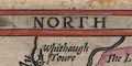
The map borders are labelled:- NORTH / EAST / SOUTH / WEST The map is printed with North at the top of the sheet. |
|
|
|
||
|
scale line
scale |
Printed lower left is:-
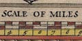
THE SCALE OF MILES chequered and labelled in miles, with extra chequering in half miles, tinted red and white. The 10 miles = 64.8 mm gives a scale 1 to 248356 wrongly assuming a statute mile, the mile used by John Speed is probably an Old English Mile about 1.25 statute miles, but I have not checked this. The map scale is about:- 1 to 250000 4 miles to 1 inch |
|
|
|
||
|
sea area
sea moire effect sea monsters ships |
The sea area is engraved in a moire effect, tinted green
blue, labelled in swash lettering:-
THE IRISH SEA The outer part of the Solway Firth is labelled:- Itunae Baye 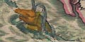
A sea monster; snout like a pig, ruff, forepaw held in front, spouting like a whale, is engraved off the coast below St Bees Head. 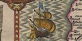
Off Allonby is a ship, tinted brown; square stern with a rudder, three masts, fore main and top sails, main main and top sails, lug sail on the mizzen, and two large plain flags, tinted blue. |
|
|
|
||
|
coast line
coast shaded foreshore headlands harbours |
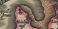
The coast line is shaded for emphasis. Foreshore areas in river estuaries are outlined and pecked, those in the Solway Firth tinted brown. Harbours are hardly noticed. Just north of Workington in the estuary is:- Derwenfote haven The headland at St Bees is labelled:- St. Bees head |
|
|
|
||
|
rivers
bridges |
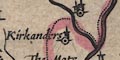
Rivers are drawn by a double wiggly line with form lines, perhaps quote broad at an estuary, tapering upstream to a single line. Some rivers are labelled, eg:- Eden flude Elne flu Wampul flud On some maps it seems reasonable to assume that the abbreviations fl or flu, stand for Latin flumen or fluvius, a river. On this map, in which John Speed uses English for his labelled borders, which is perhaps less usual, notice that flu is expanded to flud or flude for some river names. The English word flood is legitimate synonym for river, not necessarily with the expected connotation of a river in flood. Be careful of jumping to the conclusion that fl and flu abbreviate a Latin not the English word. The early 17th century is a stage in our culture when English was becoming more acceptable for serious works, in preference to Latin. Bridges are marked over some rivers by a double line crossing and interrupting the stream. (This map does not show roads.) There are examples of various sizes, at Carlisle, Keswick, at Ouse Bridge, over the Wampool south of Gamelsby, etc. A bridge might be labelled, eg:- 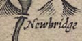
Newbridge in Lancashire North of the Sands. |
|
|
|
||
|
lakes
islands |
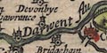
Lakes are drawn in outline, shaded. Some are labelled:- Brodwater [in Ennerdale] Devok flu Thurlmyre Ulles flu Wynandermere flu Notice again the use of flu for flud, applied to lakes, just big wide bits of river really! Others can be recognised:- Bassenthwaite Lake Brothers Water Buttermere Coniston Water Crummock Water Derwent Water Loweswater Rydal Water (?) Wast Water Though there is some uncertainty. An island might be drawn in a lake, as in Rydal Water? and in Derwent Water, labelled:- Darwen Iland |
|
|
|
||
|
relief
hillocks |
Relief is indicated by hillocks shaded mostly to the east, tinted brown. The hillocks are more knobbly than those used by John Speed for places in southern England. The hillocks are distributed to show the hilly lakeland and flatter northern valley, and the hilliness of The Pennines. But, no real impression is given of the shape of the mountain land. A few hills are labelled, eg:- Hard Knot Dent Hill High Gate Skiddow hill |
|
|
|
||
| beacons |
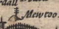
A post with three cross bars atop a hillock. is labelled:- Mewtoo becon This is probably Moota Hill, Blindcrake. |
|
|
|
||
|
woods
forests trees |
Woodland is indicated by tree symbols, tinted green. They
occur in parks, but also in groups which might be labelled,
eg:-
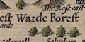
West Warde Forest Inglewood Forest Medohush wood An area with no trees might, correctly, be labelled as a forest, eg:- Copeland Forest |
|
|
|
||
| parks |
Parks are drawn by an outline with fence palings, the
interior perhaps having some tree symbols, and tinted green.
The park might be labelled, eg:-
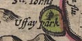
Ussay park Barrenwode park |
|
|
|
||
|
county
swash lettering |
The county boundary is a dotted line, or the coast line, tinted red on the inner side. Although the boundary, as today come down the Glencoyne Beck and up the middle of Ullswater, the shape of the lake and position of the stream is not right. The Westmorland Lancashire boundary enters the top of Windermere and goes down the middle of the lake, not as today. Adjacent counties are labelled, eg:- Part of Lancas: Shire and in moderate swash lettering:- PART OF NORTHUMBERLAND PART OF WESTMORLAND To the north is:- PART OF SCOTLAND Some map features are plotted outwith the county for the sake of continuity, particularly in Lancashire North of the Sands. Two pillars on a hillock are labelled:- 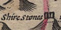
Shire Stones upon Wrenose on the county boundaries. |
|
|
|
||
| settlements |
Settlements are positioned by a dot and circle, with
added elements, differentiated further by style of
labelling. There is no table of symbols to guide the user;
the allocation into city, town, village, hamlet used below
is just a handy device of this author.
|
|
| cities |
dot and circle, buildings and towers, tinted red;
labelled in upright block caps:-
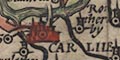
CARLILE |
|
| towns |
dot and circle, buildings and towers; labelled in upright
lowercase text, eg:-
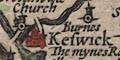
Keswick Ierbye |
|
|
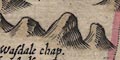
villages
hamlets |
dot and circle, two towers or one; labelled in italic
lowercase text, eg:-
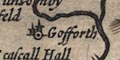
Gosforth Cumrew 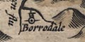
Borrodale Litle Langdale Wasdale chap. |
|
|
Other map features are labelled in italic lowercase.
|
||
|
|
||
| miscellaneous | ||
|
|
||
|
antiquities
roman sites roman wall |
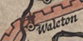
A crenellated wall is drawn from the coast of the Solway Firth at Boulnes, eastward through Carlile, up river north east then east north east through Waleton, Burdswold, Willolor, by Thirlewall cast, then Wall Towne and into Northumberland; labelled:- THE PICTS WALL Printed upper right is a circular cartouche matching the title cartouche:- THE PICTS WALL The ancient and outmost limitts of the Romane Empire, was first made of Turffs and Staks by Hadrian the Emperoure. Afterwards by Severus much strengthned and extended through the Maine even, from Sea to Sea, a worke soe famous, that the title Britannicus was given a Surename to the Emperoure. And lastly in the declining estate of that Empire, It was built of firme stone 8. foote brode and twelve foote hygh, beginning in the West at Boulnes near the Baye of Itunae, and continewed unto the mouth of Tyne in the East. Running through vast montanes, for the most part in a straight lyne ascending and descending over steep Craggs and hye hills: conteyning in length nere 100 miles. The tract whereof in many places yet appeareth, only dispoyled of his Battlements. In it were built watch towres, distant 1000 paces eiche from other, wherein were souldiers kept, for the securing of the confines from the incursions of the enemy. Above the cartouche is an engraving of a roman ?coin, the head os Severus, tinted by the colourist, and inscription:- L. SEPT. SEVERUS. PIUS AUG. BRIT The banners of the 'supporters' to this design show a fleur de lys and a portcullis respectively. |
|
|
|
||
|
mines
copper mines |
At Keswick there is a label:-
The mynes Royall This is perhaps Goldscope Lead Mines. A knobbly hillock between Mosedale and Ierbye has two circles drawn on it, labelled:- 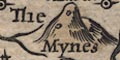
The Mynes |
|
|
|
||
| stones |
Two pillars on a hillock are labelled:-
Shire Stones upon Wrenose and two more above Grasmere:- Dunbalrase Stones ie Dunmail Raise Stones. |
|
|
|
||
| tents |
A tent symbol is engraved on Sollome Moss at the head of
the Solway Firth, and another by Penreth.
These represent battle sites and are copied from a map by Woutneel 1603. |
|
|
|
||
|
antiquities
british tribes |
Labelling the area east of Carlisle:-
THE BRIGANTES |
|
Lakes Guides menu.