 Simons 1635

|

|
|

|
back to object record | |
| A Guide Book | ||
|
The tables of distances with their maps are included in:-
|
||
|
A DIRECTION FOR the English TRAVILLER By which he Shal be
inabled to Coast about all England and Wales. And also to
know how farre any Market or noteable Towne in any Shire
lyeth one from an other, and whether be East, West, North,
or South from ye Shire Towne As also the distance betweene
London and any other Shire or great towne: with the
scituation thereof East, West, North, or South from London.
By the help also of this worke one may know (in what Parish,
Village, or mansion house soever he be in) What Shires he is
to passe through & which way he is to travell till he comes
to his Journies End. / Infoelix cuius nulli Sapientia
prodest / Are to be Sold by Mathew Simons at the golden Lion
in Ducke laine, A[o.] 1635. / Jacob van Langeren sculp:
|
||
| MAP FEATURES | ||
|
|
||
| title |
Printed top left of each table of distances is a
title:-
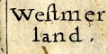
Westmer / land Cu~berland. |
|
|
|
||
|
orientation
up is N labelled borders |
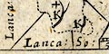
Radiating out from the maps are lines for the cardinal and half cardinal directions. The four sides of the map are labelled with the direction and the name of the adjacent county, thus for Westmorland:- Cumberland N. / Yorkshire East / Lanca: So: / Lanca: & Cumb. W. and for Cumberland:- Scotland North. / Northuberland & Duresme. East / Westmorla~d & Lancashire S. / The Sea West The maps are printed with North at the top of the sheet. |
|
|
|
||
|
scale
scale line dividers |
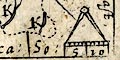
A scale line is fitted into the tiny map area, with a pair of dividers; marked in miles, labelled 5 and 10. For Westmorland the 10 miles = 6.1 mm gives a scale 1 to 2640000 wrongly assuming statute mile. The map scale is about:- 1 to 2600000 42 miles to 1 inch Cumberland, scale line 10 miles = 6.3 mm gives 1 to 2568649 wrongly assuming statute mile. The map scale is about:- 1 to 2600000 41 miles to 1 inch With such tiny scale lines the estimates are approximate; the maps are not accurate scale plots. |
|
|
|
||
|
sea area
sea plain |
The sea to the west of Cumberland is plain. The border
label on this side of the map is:-
The Sea West |
|
|
|
||
|
coast line
coast shaded |
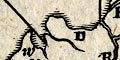
The coast line of Cumberland is emphasised by shading. |
|
|
|
||
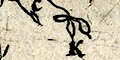
| rivers |
Some rivers are crudely shown by a double line tapering to a single line. It might be possible to recognise rivers by the arrangement of settlements, but none is labelled. |
|
|
|
||
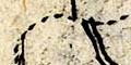
| lakes |
On the Cumberland map some lakes are suggested at the head of some rivers. The arrangement of three lakes near Keswick does not encourage trust in any attempt at identification. |
|
|
|
||
| county |
The county boundary is a dotted line. Adjacent counties are given in the labelled borders, eg:- Cumberland N. |
|
|
|
||
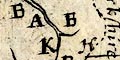
| settlements |
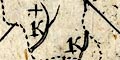
Settlements are marked by their initial letter. Duplications are not resolved; you have to know what is where, and as the maps are crude this not always easy. For example there are three letter Ks in Westmorland which look to be: Kirkby Stephen east, Kirkby Lonsdale south, and Kendal south east. But notice that the table of symbols has four places beginning K: Kirkland N, Kirkby Steven N, Kirkby Landall S, and Kendall. A place in the table is not always on the map, and vice versa. The K for Kendal has a plus sign (+) which might indicate importance. In Cumberland it is Cockermouth has C+ not Carlisle. The introduction has:- The Market Townes in every table are distinguished from the rest by greate letters, and the letter for ye Shire townes hath a crosse on the topp to distinguish it from the other. The great letters cannot safely be distinguished from the others. |
|
| Places | ||
|
In the table of distances the places are listed in no
apparent order, top to bottom at the side, right to left at
the top, with an extra place in each list not in the other
list. The spellings in the two lists might not agree. Each
place (in the left list) has a direction, presumably
indicating where it is on the map.
|
||
|
NB: As yet, I have not used distances to check or help
identify places. Identifications so far are:-
|
||
Lakes Guides menu.