 Camden 1607 map

|

|
|

|
back to object record | |
| MAP FEATURES | ||
|
|
||
| swash lettering |
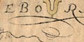
Swash lettering fills spare space round the map. |
|
|
|
||
|
title cartouche
strapwork cartouche map maker engraver |
Printed in a strapwork cartouche, upper right:-
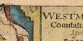
WESTMORLANDIAE Comitatus qui olim Spectauit ad BRIGANTES Printed below the scale line, lower right:- Christophorus Saxton scripsit William Kip sculpsit |
|
|
|
||
|
orientation
labelled borders |
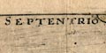
The four borders are labelled with the cardinal directions in Latin:- SEPTENTRIO ORIENS MER[I]DIES OCCIDENS |
|
|
|
||
|
scale
scale line |
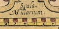
Printed lower right is a:- Scala Miliarium. chequered in half miles, labelled in miles. The 8 miles = 55.4 mm gives a scale 1 to 232396 wrongly assuming a statute mile. From this the map scale is about:- 1 to 230000 ? 3.5 miles to 1 inch It is likely that an Old English Mile was used, about 1 1/4 statute miles, thus the scale is more likely about:- 1 to 180000 3 miles to 1 inch |
|
|
|
||
|
sea area
sea pecked |
The small area of sea that is shown in the river
estuaries is pecked, and tinted blue.
|
|
|
|
||
|
coast line
coast shaded foreshore |
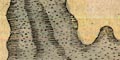
The coast line in the river estuaries is shaded for emphasis, and shaded again off the foreshore shallows marking the river channels. |
|
|
|
||
|
rivers
bridges |
Rivers are drawn by a tapering double line, with form or stream lines. They are possibly tinted blue. A few rivers are labelled, eg:- Eden flu: Spur flu: [Sprint] Troutbek The abbreviation flu is used for rivers and lakes, and I would hesitate to say what it stands for, flumen, fluvius, flud, etc. Some bridges are drawn by a double line crossing and interrupting a stream (there is no road network). 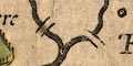
Most bridges are not labelled, but notice:- New bridge [Newby bridge] |
|
|
|
||
| lakes |
Lakes are drawn by an outline, the interior pecked like the sea, and the shore shaded, some tinted blue. Some lakes, in and out of the county. are labelled:- Thurle myre flu: Vlles flu: Wynandermere flu: Other lakes can be recognised, perhaps:- Brothers Water Coniston Water Derwent Water Esthwaite Water |
|
|
|
||
|
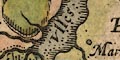
relief
hillocks |
Relief is indicated by knobbly hillocks, tinted pale
brown. With some imagination it is possible to see the Eden
Valley with the Pennines on one side and the hills of The
Lakes on the other. One or two hills are labelled, eg:-
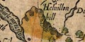
Helvillon hill Huseat moruill hill |
|
|
|
||
|
woods
trees |
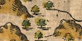
Some woodland is indicated by tree symbols, tinted in pale and mid green. |
|
|
|
||
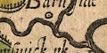
| parks |
Parks are drawn by an outline with fence palings, the
interior tinted green. A park might be labelled, eg:-
Camswick p~k 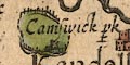
|
|
|
|
||
| county |
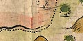
The county boundary is a dotted line, usually continued beside another feature that makes the boundary. There is a band of tint along the inner side of the boundary and for each adjacent county: Westmorland green, Lancashire yellow, Cumberland pink, Durham yellow, Yorkshire pink (all faded). Adjacent counties are labelled, eg:- CUMBERLANDIAE PARS EBORACENSIS PARS Quite a number of features are shown outwith the county, in Cumberland, Lancashire, Yorkshire. A number of features on the county boundary are noticed, see the miscellany below. |
|
|
|
||
| settlements |
Settlements are marked by a circle or dot and circle,
and/or drawings of buildings etc; partly differentiated by
style of labelling.
|
|
| towns |
dot and circle, buildings and towers, tinted red;
labelled in upright lowercase text, eg:-
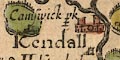
Kendall Apellebye |
|
| villages |
perhaps just a tower, tinted red; labelled in italic
lowercase text, eg:-
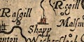
Shapp and notice, marked as a village:- 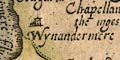
Wynandermere |
|
| hamlets |
circle, and sometimes a dot and circle; labelled in
italic lowercase text, eg:-
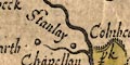
Stanlay [Staveley] |
|
| castles |
A castle might be marked by a building and pair of
towers; labelled, in italic lowercase text, eg:-
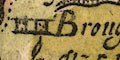
Brougham cast: |
|
|
|
||
| miscellaneous | ||
|
|
||
|
stones
county |
A group of 'stones' on a hill, tinted red, are:-
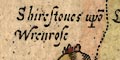
Shirestones upo~ Wrenrose A stone on a hill is:- 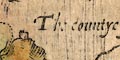
The countye stone |
|
|
|
||
|
antiquities
stones county |
Two stones on the county boundary are:-
Dunbalrase stones |
|
|
|
||
|
crosses
county |
Notice on the east county boundary:-
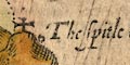
Holomill crosse There is a cross on a hill:- 
which is Rey Cross. |
|
Lakes Guides menu.