 Rocque 1746

|

|
|

|
back to object record | |
| MAP FEATURES | ||
|
It is worth studying this map alongside the map of
Westmorland by Thomas Badeslade, 1742.
|
||
|
|
||
|
title
map maker |
The map carries no title, or any indication of the map
maker, engraver, or publisher.
|
|
|
|
||
|
orientation
compass rose up is N |
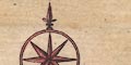
Printed upper left is a compass rose; circle, star points for cardinal and half cardinal directions, North marked by a fleur de lys. The map is printed with North at the top of the sheet. |
|
|
|
||
|
scale line
scale |
Printed upper left is a scale of:0-
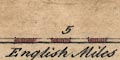
English Miles chequered in miles, labelled at 5 miles intervals. The 10 miles = 33.1 mm giving a scale 1 to 486207 assuming a statute mile. The map scale is about:- 1 to 490000 7.5 miles to 1 inch |
|
|
|
||
|
sea area
sea plain |
The small area of sea that is shown, is plain.
|
|
|
|
||
|
coast line
coast form lines |
The coast line is emphasised by form lines, in the map
studied these are tinted blue. The sea area is
labelled:-
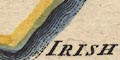
THE IRISH SEA |
|
|
|
||
|
rivers
bridges |
Rivers are drawn by a double, then a single wiggly line tapering upstream. Some rivers are labelled, eg:- Can or Kent R. Lune R. Leven B. The last I take to be Leven Beck though it could be Leven Bridge in its position. Quite a lot of rivers and estuaries are shown on this small map, but, along with coast line, I would put little trust in the accuracy of their mapping. There are a few roads on the map which cross and interrupt streams, indicating a bridge. There are also interruptions, gaps, in streams where no road is shown, suggesting a bridge, for examples, at Kirkby Lonsdale on the River Lune. At the south end of Winander Mere a settlement is labelled:- New Bridge though no bridge is indicated. South of Tebay a tiny segment of road, detached from any route, is engraved across the Burrow River - not interrupting the stream, perhaps a ford rather than a bridge, or just a mistake or afterthought. This is labelled:- 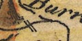
Burrow Bridge Labelled between a broad part of the Kent Estuary and the Lancaster to Kendal road is:- Waterfall with no river for it to be on. |
|
|
|
||
| lakes |
Some lakes are drawn in outline with form lines, tinted
blue on the map studied. Windermere lake has a lot of
islands. A few lakes are labelled, eg:-
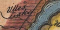
Ulles Lake Winander mere Also in Westmorland, uncertain because of the crudeness of the mapping, it is possible to recognise:- Hawes Water Hayes Water ? Rydal Water ? Thirlmere ? Grasmere ? Kentmere And in adjacent Cumberland are:- Derwent Water Wast Water of Buttermere or ? Coniston |
|
|
|
||
|
relief
hillocks |
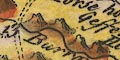
Relief is indicated by a few groups of small hillocks, tinted brown on the map studied, with a yellow wash round about. The Westmorland part of the Lakes is not shown to be particularly hilly. There are a few relevant labels, with symbols or without:- Gefferyes Hill Whinfield Hill Rumary Fell in Westmorland. It is difficult to see why these are chosen for labelling. Just outside the county there are also, for example:- Fournes Fells Hard Knot Hill and marking the boundaries of Cumberland, Yorkshire, and Durham:- Kelloplaw Hill |
|
|
|
||
|
woods
forests |
Tree symbols are used to indicate woodland, the area
around tinted pale green on the map studied. Some forests
are labelled, eg:-
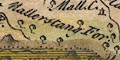
Mallerstang For. Markendale For. [Martindale?] Milburn For. Forest does not imply trees: Mallerstang which is not particularly wooded is drawn with trees; Milburn has no tree symbols. |
|
|
|
||
| parks |
Parks are drawn by a rounded outline with a fence, tinted
green on the map studied. Some parks are labelled by name or
by the name of a house, eg:-
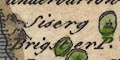
Brigster P. Sisergh Holmes P. Wharton Hall |
|
|
|
||
| county |
County boundaries are a dotted line. The Westmorland boundary is emphasised by shading on the outside. On the map studied the boundaries are also emphasised by tints, a different colour applied along the inside for each county. Westmorland has a narrow pale brown tint. The adjacent counties have a broad band of colour, plus a paler wash in the county area; Lancashire yellow, Cumberland pink, Northumberland yellow, Durham green, Yorkshire North Riding green, Yorkshire West Riding yellow. The adjacent counties are labelled, eg:- PART OF CUMBERLAND P. OF LANCASHIRE Rivers and roads might be continued outwith the county for continuity, and a few settlements, lakes, hills, etc are marked and/or labelled, eg Keswick, Penrith, Hard Knot Hill, Derwent Water. |
|
|
|
||
|
settlements
electoral data |
Settlements are marked by a circle, perhaps with added
elements, differentiated by style of labelling. Some places
are marked by a small building or tower, but it is not
always clear whether a village or just a house is meant.
|
|
| towns |
circle, tower; labelled in upright lowercase text,
eg:-
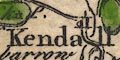
Kendall Appleby Appleby as county town has two towers; each tower has an asterisk on top, indicating that it is a borough sending two members to Parliament. |
|
| villages |
circle, or building; labelled in italic lowercase text,
eg:-
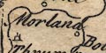
Morland 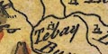
Tebay Seggeswick Gresmere |
|
| houses |
Various houses, halls, castles, etc are indicated by a
small building symbol and labelled, eg:-
Pendragon Castle Preston Hall Howgin C. |
|
|
|
||
| roads |
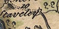
Some roads are drawn by a double line, solid or dotted for fenced or unfenced roads. One line is, perhaps, bolder than the other, and the lighter line is sometimes difficult to see. The destination of a road might be labelled, eg:- to Lancaster The roads are:- From Lancaster, Lancashire; through Burton, Milthorpe, Kendal, up Betone Hill, past Horse Houses, Shap, Westmorland; across the Eymot River to Penrith, and continued north est by The Military Way in Cumberland, towards Carlisle. From Kendal, past Barnside, through Staveley, Winander Mere (marked and labelled as a village), Ambleside, past Gresmere village, Westmorland, leaving the county at Dunmaile Raise Stones; then Thurlspot, Cust, to Keswick, Cumberland. From Penrith, Cumberland; passing Broom Castle, then Appleby, Brough, Westmorland; from where two routes continue eastwards, across Stainmoor Forrest into Yorkshire, and a little to the north across Luna Forrest into Yorkshire and then Durham. From a junction on the Penrith to Appleby road, north out of Westmorland; into Cumberland. From Ambleside ENE then NW, meant to be the Kirkstone Pass road, passing Paterdale, then beside Ulles Lake and the Eymot River to Penrith. Road distances are labelled along the two Ogilby routes:- Burton 9 Kendal 13 Shap 5 Penrith Kendal 10 Ambleside 12 Keswick |
|
|
|
||
| miscellaneous | ||
|
|
||
| mines |
Several mines are marked by a cross,(x), labelled:-
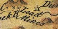
Lead Mines in the north east of the county, near Dun in Milburn Forest. Also north of Brough at the west end of Rumary Fell. There are more lead mines in Yorkshire, west of Kirby Steven. Copper Mines are labelled in the hills on the county boundary east of the Langdales. And on Stainmoor, south of Dale, is:- The Coal Pitts |
|
|
|
||
| stones |
A circle by the Ambleside to Keswick road on the
Westmorland Cumberland border is labelled:-
Dunmaile Raise Stones And south of Shap, east side of the road is:- Stone Heaps |
|
|
|
||
|
roman sites
roman forts |
West of Brampton is a building symbols labelled:-
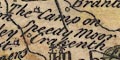
The Camp on Speedy Moor |
|
|
|
||
| horse houses |
On the remote 13 miles of road from Kendal to Shap,
across Shap Fells, are two places labelled:-
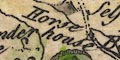
Horse house I am not sure what these are, but it is possible they indicate stables where horses are to be had for the traveller, replacements for post chaises, and so on. In more populous places these facilities could be taken for granted, not marked. |
|
Lakes Guides menu.