 Ptolemy 1540

|

|
|

|
back to object record | |
| Map Features | ||
|
The map shows all of England and Wales, with the southern
part of Scotland, eastern part of Ireland and some of the
coast of France. These notes are biased towards an interest
in the Westmorland and Cumberland area; the interesting
thing to do would be to compare how well Sebastian Munster
has used Ptolemy's data, and later data, to draw his map:
that is not our task.
|
||
|
|
||
|
orientation
up is E |
The map is drawn with East at the top of the page.
|
|
|
|
||
| scale |
A scale can be estimated, roughly. Using the distance
from Carlisle to London, the map scale is about:-
1 to 3000000 50 miles to 1 inch |
|
|
|
||
|
sea area
sea waves |
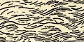
The sea area is engraved to represent waves. A couple of sea areas are labelled:- OCEANUS GERMANICUS [North Sea] Mare Anglicu~ [English Channel] |
|
|
|
||
| coast line |
The coast line is not emphasized. |
|
|
|
||
| rivers |
Rivers are crudely drawn by a double line tapering inland. On this small map only great rivers are shown, and perhaps labelled, eg:- Sabrina fl [Severn] 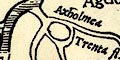
Some of the rivers are shown with intriguing circular connections which don't make a lot of sense. Recognizable rivers in Cumbria are:- Solue[u|ii]s fl. [Eden, River] Caldew, River Lune, River |
|
|
|
||
|
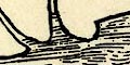
relief
hillocks |
Groups and rows of hillocks are used to indicate relief. For example The Pennines are marked, and some mountains into the central Lakes area. |
|
|
|
||
| forests |
The mountains of north Wales appear to have trees growing
upon them. Otherwise woodland is not indicated.
|
|
|
|
||
| county |
Some county areas are labelled, though there are no
boundaries (they didn't exist in Ptolemy's time), eg:-
Northumbria Devonia Somerset Nortfolk The first of these might be the kingdom rather than the county. A table printed upper right has some translations:- Interpretationes vulgares quorundam nominum. ... Devonia Devonschyre ... Somersetus Somerset |
|
|
|
||
| countries |
England is taken for granted as the subject of the map,
but:-
SCOTIA WALLIA are labelled, as are adjoining lands over the sea. England is marked by the royal standard with the quartering of the 15th and 16th centuries:- 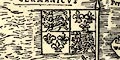
quarterly 1 and 4 three fleur de lys 2 and 3 three lions passant guardant Scotland has its flag:- 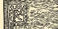
a lion rampant within a tressure flory |
|
|
|
||
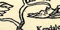
| settlements |
Settlements are marked by a circle with a drawing of a
town, buildings and towers. The size of label varies, which
may be just to fit the available space or as a
differentiation of size of place.
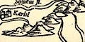
The places in Cumbria are:- 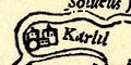
Karlil [circle, buildings and towers, at meet of Eden and Caldew rivers] Kendale [no symbol; misplaced] Carnnel [Cartmel; circle, building, tower, on the coast] |
|
Lakes Guides menu.