 Post Office 1850s-1900s

|

|
|

|
back to object record | |
| MAP FEATURES | ||
|
Note that detail comments are made for Hampshire (notes not
yet versioned for Cumbria).
|
||
|
|
||
| title |
Printed upper right is:-
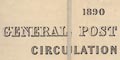
1890 GENERAL POST OFFICE CIRCULATION MAP FOR ENGLAND & WALES. |
|
|
|
||
| map maker |
Printed bottom right is:-
Stanford's Geographical Establishment, London |
|
|
|
||
|
orientation
up is N |
The map has no compass rose or latitude and longitude
scales. It is printed with north at the top of the page.
|
|
|
|
||
|
scale line
scale |
Printed below the title and table of symbols is a:-
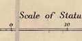
Scale of Statute Miles. The scale has 30 miles marked at 10 mile intervals, plus 10 miles leftwards divided at miles, marked at 5 miles intervals. The 30+10 miles = 99.7 mm gives a scale 1 to 645675; the map scale is about:- 1 to 650000 10 miles to 1 inch |
|
|
|
||
| table of symbols |
Printed below the title is an:-
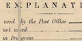
EXPLANATION Railways used by the Post Office [bold line, and a line for a station] Railways not used [double light lines] Railways in Progress [double light dotted lines] Mail Coaches & Mail Carts [line tinted red] Stage Coaches & Omnibuses [line tinted green] Rural Postmen mounted [line tinted blue] Rural Postmen on foot [line tinted yellow] Tricycle Posts [line tinted brown] Boundary of Counties [light dotted line] Boundary of Surveyor's Districts [bold dashed line] Post Towns [name and double circle] Money-Order Sub.-Offices [name and circle] Points at which Mail Carts &c. branch or terminate [name and dash] (The scale line is drawn next.) To avoid overcrowding the map, only a selection of Money Order Sub-Offices is given in the populous Districts The portions of the Map coloured pink mark the separate districts of the Postmasters of Manchester Liverpool and Birmingham |
|
|
|
||
| county |
The county boundaries are drawn by a light dotted line; the bolder dashed line is the post office surveyor's district boundary. 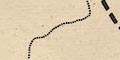
The post office surveyors' districts bear no relationship to counties (just as postcodes today are independent of local authority administration; confusing to the public, but making good sense to the postmen delivering the mail.) |
|
|
|
||
| settlements |
Settlements relevant to the subject of the map, letter
delivery, are shown. The various place markers are described
in the table of symbols.
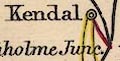
post town 
money order sub office 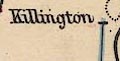
end of a post route |
|
|
|
||
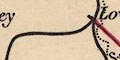
| roads |
Roads are implied by the routes of the mounted and foot
postman's walks in rural areas. The routes are diagrammatic,
smoothed-out lines in most examples. Delivery by:-
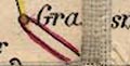
mail coach or mail cart, 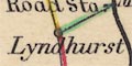
stage coach or omnibus (can't find an example in Cumbria), 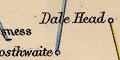
mounted rural postman, 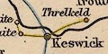
rural postman on foot, 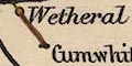
and tricycle (this might be the only example in Cumbria; the colouring of the route to Grange 0ver Sands is not clear, but it could also be a tricycle route). |
|
|
|
||
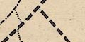
| railways |
Railways are drawn by bold lines if they are part of the postal system, otherwise by light double lines, and by light dotted lines if they are in still course of construction. |
|
Lakes Guides menu.