 Post Office 1850s-1900s

|

|
|
|
item:- Hampshire Museums : FA2001.173 image:- © see bottom of page |
click to enlarge |
|
|
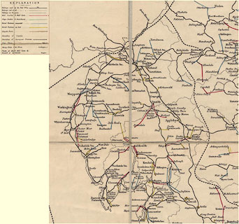
Map, hand coloured engraving, General Post Office
Circulation Map for England and Wales, scale about 1 to
650000, about 10 miles to 1 inch, published by Stanford's
Geographical Establishment, London, 1890.
The map shows how the mails are delivered across the country by railway, mail coaches and carts, stage coaches and omnibuses, rural postmen mounted or on foot, or on tricycles. Post towns, money order sub offices, and the end points of mails are plotted. |
||

|
Post Office 1850s-1900s | |
| map feature:- | sectioned for folding & mounted & up is N & scale line & table of symbols & county & settlements & railways & roads & post roads | |
| inscription:- |
printed title
1890 / GENERAL POST OFFICE / CIRCULATION MAP / FOR / ENGLAND & WALES. |
|
| inscription:- |
printed bottom right
Stanford's Geographical Establishment, London |
|
| scale line:- | 30+10 miles = 99.7 mm | |
| wxh, sheet:- | 89x111cm | |
| wxh, sheet, folded:- | 18x28cm | |
| wxh, map:- | 867x1067mm (approximately) | |
| scale:- | 1 to 650000 ? (1 to 645675 from scale line assuming modern mile) | |
|
|
notes | |