 Philip 1920s

|

|
|

|
back to object record | |
| MAP FEATURES | ||
|
|
||
|
title
map maker publisher |
Printed lower left:- PHILIP'S NEW MAP OF THE LAKE DISTRICT OF CUMBERLAND, WESTMORLAND AND LANCASHIRE Printed at the bottom:- GEORGE PHILIP & SON, LONDON & LIVERPOOL |
|
|
|
||
|
cover
advertisements index map |
The map is mounted on linen and folded 4x3 panels, in a
card cover. On the cover, black on red:-
PHILIPS' CYCLISTS' MAP OF THE LAKE DISTRICT / PRICE ONE SHILLING The map and cover differ between Philip's and Philips'. Perhaps the map originates from an earlier period before the Son joined his father, George. Inside the cover is an advertisement for maps in the series:- PHILIPS' UNRIVALLED SERIES OF CYCLING MAPS. 'Wonderful value and perfection from a Cyclist's point of view.' - Cycling. There is an index map of a 33 sheet topographical map of England and Wales, and a list of:- PHILIPS' COUNTY CYCLING MAPS. With Main Roads and Dangerous Hills coloured and Repairing Shops and Hotels indicated. Size 18 by 14 1/2 inches. Mounted on cloth, in cloth case, 1s. each. Superior mounting 1s. 6d. each. The list includes:- The Lake District |
|
|
|
||
|
orientation
up is N |
The map is printed with North at the top of the
sheet.
|
|
|
|
||
|
scale line
scale |
Printed above the scale line, lower left:-
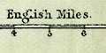
English Miles The scale line is chequered and labelled in miles. The 10 miles = 61.5 mm gives a scale 1 to 261680 assuming a statute mile. The map scale is about:- 1 to 260000 4 miles to 1 inch |
|
|
|
||
| lat and long scales |
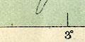
Printed in the map borders are scales of latitude and longitude for a rectangular projection; marked and labelled at 10 minute intervals. The map includes from 2d 28m to 3d 46m W, 54d 2m to 54d 56m N, approximately; Westmorland cut off east of Appleby, Cumberland cut off north of Brampton, Lancashire north of the sands, etc. |
|
|
|
||
| table of symbols |
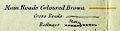
Printed lower left is a minimal table of symbols:- Main Roads coloured Brown [bold brown line] Cross Roads [double line, uncoloured] Railways [chequered double line] Station [dot] On a sheet pasted on the back of the map is more explanation:- THE LAKE DISTRICT. ABBREVIATIONS ON MAP INDICAE:- C. Consul of Cyclists' Touring Club in that town. H. Hotel appointed and recommended by Cyclists. X. Where machines may be repaired. Then there are notes about the gradients of hills (see under roads). A list of hotels follows some marked with labels:- T.H. Temperance Hotel. C.T. Coffee Tavern. All these extra symbols are overprinted on the map in red. |
|
|
|
||
|
sea area
sea tinted sandbanks lightships |
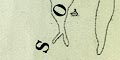
The sea area is printed blue. Some ares are labelled, eg:- SOLWAY FIRTH MORECAMBE BAY Allonby Bay Sandbanks are drawn in outline by a dotted line and might be labelled, eg:- Silloth Bank Middle Bank Near the seaward end of Silloth Bank is a small symbol of a ship, perhaps a lightship? |
|
|
|
||
|
coast line
foreshore sands headlands harbours lighthouses |
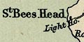
The coast line is not emphasized. Foreshore sands and shallows are outlined by a dotted line, and might be labelled, eg:- Duddon Sands Some headlands are labelled, eg:- Humphreys Head Hodbarrow Point Some harbours are noticed, eg:- Silloth Port and Dock Some lighthouses are marked by a block, and labelled, eg:- Cott Light [Silloth] Light Ho. [St Bees] Walney Light Houses |
|
|
|
||
|
rivers
bridges ferries |
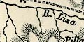
Rivers are drawn by a wiggly line tapering upstream. Some rivers are labelled, in various styles, eg:- Steers Pool R. Kent Wyth B. Borrow Beck River Eden Keld Gill A waterfall might be noticed and labelled, eg:- Airey Force Stock Gill Force Bridges are implied by a road crossing and interrupting a stream. A few bridges are labelled, though it is not always easy to know whether the label attaches to the bridge or the place, eg:- 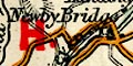
Newby Bridge Troutbeck Br. Duddon Bri. The ferry across lake Windermere is marked by a dotted line and labelled:- 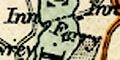
Ferry |
|
|
|
||
| lakes |
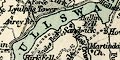
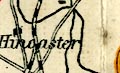
Lakes are drawn in outline, perhaps tinted blue. Many are labelled:- Angle Tarn Angle Tarn [Patterdale] Authorn L. BASSENTHWAITE WATER Beacon Tarn Blea Tarn [Gt Langdale] Blea Tarn [Watendlath] Blea Water [Shap] Bleaberry tarn Blelham Tarn Bowscale tarn Brothers Water Burnmoor Tarn Buttermere Codale Tarn CONISTON WATER CRUMMOCK WATER Dale Head Tarn DERWENT WATER Devoke Water Elter Water ENNERDALE WATER Esthwaite Water Grasmere Lake Greycrag Tarn Grisedale Tarn Harrop Tarn Hawes Water Hayes Water Kentmere Reservoir Keppelcove Tarn Levers Tarn Lily Mere Little Tarn Loughrigg Tarn Low Tarn Low Water Lowes Water Martin Tarn Over water Red Tarn Red Tarn [Helvellyn] Red Tarn [Wyth Beck] Rydal Water Scales Tarn Scoat Tarn Seathwaite Tarn Skeggles Water Small Water Sprinkling Tarn Stickle Tarn Stickle Tarn Stony Tarn Styhead Tarn Tarn Wadling Thirlmere Tindale Tarn ULLSWATER WAST WATER WINDERMERE Other lakes might be recognized, eg:- Barfield Tarn [on Black Combe] Dock Tarn [above Stonethwaite] Easedale Tarn Grayrigg Tarn Killington Reservoir Out Dubs Tarn Thurstonfield Lough [by Kirkbampton] [reservoir by Greenside Mine, now gone] [reservoir nr Staveley] |
|
|
|
||
|
relief
hill hachuring spot heights |
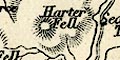
Relief is indicated by hill hachuring. Some hills are labelled, some with spot heights, eg:- Helvellyn / 3114 Gt. Dodd / 2804 Causey Pike Scafell Pikes / 3229 Honister Crag Some valleys are labelled, eg:- Eskdale Vale of Lorton Gradient information is given on roads for the benefit of cyclists (see under roads). |
|
|
|
||
| forests |
Woodland is not indicated but some forests - which does
not imply woodland - are labelled, eg:-
King's Forest of Geltsdale Naddle Forest |
|
|
|
||
| parks |
A few parks are drawn in outline, the interior pecked.
The park might be labelled by name, or the name of a great
house, eg:-
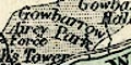
Gowbarrow Park Lowther Castle |
|
|
|
||
| county |
County boundaries are a fine dotted line, not drawn where another feature marks the boundary. They are not easy to follow unless you know where they are already. This sort of cartographic thinking, inside-out, is not uncommon today. The county areas are labelled, eg:- WESTMORLAND NORTHUMBERLAND (The map is a regional map, not a county map.) On Wrynose is a label for the Three Shire Stone where the 3 shire stoneS are. |
|
|
|
||
|
settlements
street plan |
Settlements are marked by blocks, differentiated by style
of labelling.
|
|
| cities |
groups of blocks on a street plan; labelled in upright
block caps:-
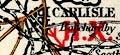
CARLISLE |
|
| towns |
groups of blocks on a street plan; labelled in italic
block caps, except Kendal in upright block caps as the de
facto county town:-
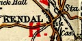
KENDAL AMBLESIDE |
|
| villages |
blocks; labelled in upright lowercase text, eg:-
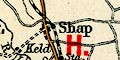
Shap Orton Sedgwick |
|
|
hamlets
houses |
a block; labelled in italic lowercase text, eg:-
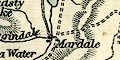
Mardale Sadgill Levens Hall A block is used even for nonnucleated settlements, such as Selside. |
|
|
|
||
|
roads
sands roads |
A network of roads is drawn by double lines, solid and dotted probably implying roads and tracks. A note lower left has:- Main Roads Coloured Brown and the double line is tinted brown. Some main roads have the lines light and bold. Hills, on this cyclists' map, are marked by an arrow alongside, overprinted in red, with one, tow, or three feathers. A note on the back of the map explains the grading:- 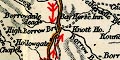
[arrow, one feather] Hills to be ridden down with caution. [arrow with two feathers] Brake on. [arrow with three feathers] Dangerous - Dismount. The marked ascents and descents are nearly all on main roads; presumably other roads are taken on sight. The cyclists' information is overprinted on an existing map. Double lines, dotted, mark routes across the sands at Duddon Sands and Lancaster Sands, the latter labelled:- 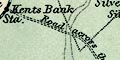
Road across the Sands at Low Water |
|
|
|
||
| railways |
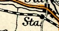
Railways are drawn by a chequered double line, stations marked by a dot and labelled:- Sta. Railways are mostly not labelled, but notice:- Midland Railway by the Settle and Carlisle line. |
|
|
|
||
| canals |
Canals are drawn by a thin line, you have to know where to look. The Lancaster Canal is shown; the Ulverston Canal might be; the Port Carlisle line is not. |
|
|
|
||
| miscellaneous | ||
|
|
||
|
antiquities
roman sites roman wall |
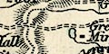
A line with ?fence palings marks the:-
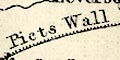
Picts Wall |
|
|
|
||
| inns |
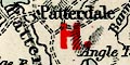
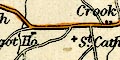
Hotels appointed and recommended by the CTC are noticed on the map by a red letter H, and listed county by county on the back of the map:- LIST OF HOTELS INDICATED ON MAP. ... LANGDALE ... New Dungeon Ghyll. PATTERDALE ... Ulleswater. SHAP ... Greyhound. ... Some of these are labelled in the list as:- T.H. Temperance Hotel. / C.T. Coffee Tavern. Other inns might be marked, eg:- Bay Horse Inn at Hucks Bridge. |
|
Lakes Guides menu.